Map of St. Pete Beach city

Map of St. Pete Beach city

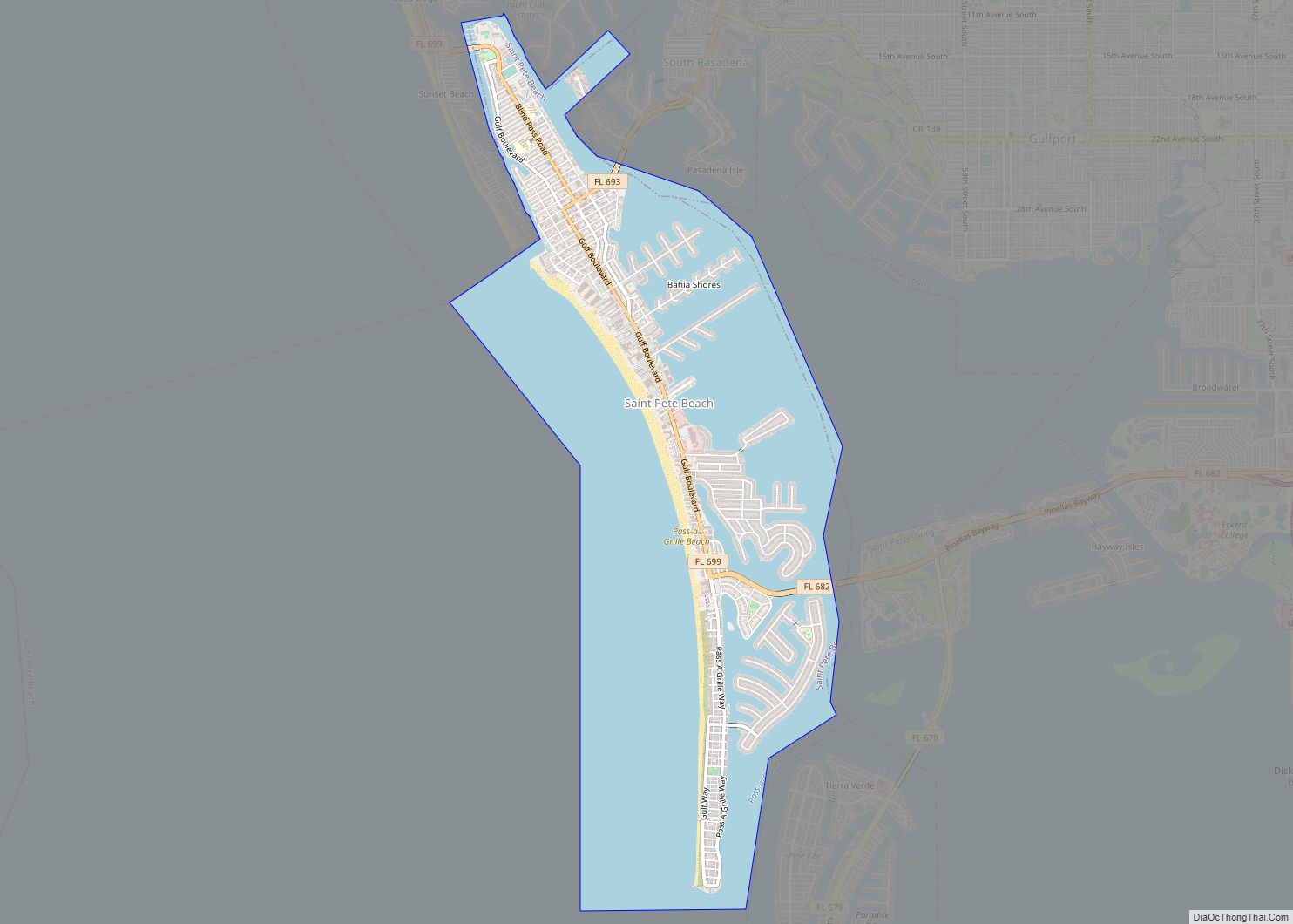
St. Pete Beach (formerly called St. Petersburg Beach) is a coastal city in Pinellas County, Florida. Known as a tourist destination, St. Pete Beach was formed from the towns of Pass-a-Grille, Belle Vista, St. Petersburg Beach and unincorporated Pinellas County.The population was 9,346 at the 2010 census. St. Pete Beach’s downtown is centered on Corey … Read more

Map of St. Marks city

Map of St. Marks city

St. Marks is a city in Wakulla County, Florida, United States. It is part of the Tallahassee metropolitan area. The population was 293 at the 2010 census. As of 2018, the population estimated by the U.S. Census Bureau is 319. St. Marks city overview: Name: St. Marks city LSAD Code: 25 LSAD Description: city (suffix) … Read more

Map of St. Lucie Village town

Map of St. Lucie Village town

The Town of St. Lucie Village is a town in St. Lucie County, Florida, United States. The population was 590 at the 2010 census. It is part of the Port St. Lucie Metropolitan Statistical Area. St. Lucie Village was incorporated in 1961 and includes the St. Lucie Village Historic District. St. Lucie Village town overview: … Read more

Map of Steinhatchee CDP

Map of Steinhatchee CDP

Steinhatchee (/ˈstiːnhætʃi/ (listen) STEEN-hatch-ee) is a Gulf coastal community in the southern part of Taylor County, Florida, United States. Steinhatchee is 38 miles (61 km) south of the county seat of Perry. Just across the Steinhatchee River is Jena, which is in Dixie County. Steinhatchee is 19.27 miles north of the town of Cross City. The … Read more

Map of Starke city

Map of Starke city

Starke is a city in and the county seat of Bradford County, Florida, United States. The population was 5,796 at the 2020 census. The origin of the city’s name is disputed. Starke may have been named in honor of local landowner George W. Cole’s fiancée’s family or in honor of Madison Starke Perry, fourth governor … Read more

Map of Stacey Street CDP

Map of Stacey Street CDP

Stacy Street is a street and surrounding census-designated place (CDP) in Palm Beach County, Florida, United States. The population was 978 at the 2020 census, which misspelled it as Stacey Street. Stacey Street CDP overview: Name: Stacey Street CDP LSAD Code: 57 LSAD Description: CDP (suffix) State: Florida County: Palm Beach County Elevation: 16 ft (5 m) … Read more

Map of Sugarmill Woods CDP

Map of Sugarmill Woods CDP

Sugarmill Woods is an unincorporated, census-designated place (CDP) in southwestern Citrus County, Florida. Sugarmill Woods CDP overview: Name: Sugarmill Woods CDP LSAD Code: 57 LSAD Description: CDP (suffix) State: Florida County: Citrus County Elevation: 82 ft (25 m) Total Area: 28.63 sq mi (74.14 km²) Land Area: 28.63 sq mi (74.14 km²) Water Area: 0.00 sq mi (0.00 km²) Total Population: 11,204 Population Density: 391.39/sq mi (151.12/km²) … Read more

Map of Stuart city

Map of Stuart city, Florida

Stuart is a city in and the county seat of Martin County, Florida, United States. Located in southeastern Florida, Stuart is the largest of four incorporated municipalities in Martin County. The population is 17,425 according to the 2020 U.S. census. Stuart is the 126th largest city in Florida based on official 2019 estimates from the … Read more

Map of Stock Island CDP

Map of Stock Island CDP

Stock Island is a census-designated place (CDP) and unincorporated community on an island of the same name in Monroe County, Florida, United States. The population of the CDP was 4,722 at the 2020 census, up from 3,919 in 2010. It is located on the portion of the island south of US 1. It is supposedly … Read more

Map of Suncoast Estates CDP

Map of Suncoast Estates CDP

Suncoast Estates is a census-designated place (CDP) in Lee County, Florida, United States. The population was 4,384 at the 2010 census, down from 4,867 at the 2000 census. It is part of the Cape Coral-Fort Myers, Florida Metropolitan Statistical Area. Suncoast Estates CDP overview: Name: Suncoast Estates CDP LSAD Code: 57 LSAD Description: CDP (suffix) … Read more

Map of Sun City Center CDP

Map of Sun City Center CDP

Sun City Center is an unincorporated census-designated place (CDP) in southern Hillsborough County, Florida, United States. It is located south of Tampa and north of Sarasota on I-75. As of the 2020 census, the population was 30,952. The ZIP Code serving the community is 33573. Sun City Center CDP overview: Name: Sun City Center CDP … Read more

Map of Sumatra CDP

Map of Sumatra CDP

Sumatra is an unincorporated community and census-designated place in Liberty County, Florida, United States. Its population was 148 as of the 2010 census. It is located on State Road 65. It is approximately 25 miles north of Eastpoint and 35 miles south of Hosford. The Prospect Bluff Historic Sites are located in Sumatra. Sumatra CDP … Read more