Map of Tiger Point CDP

Map of Tiger Point CDP

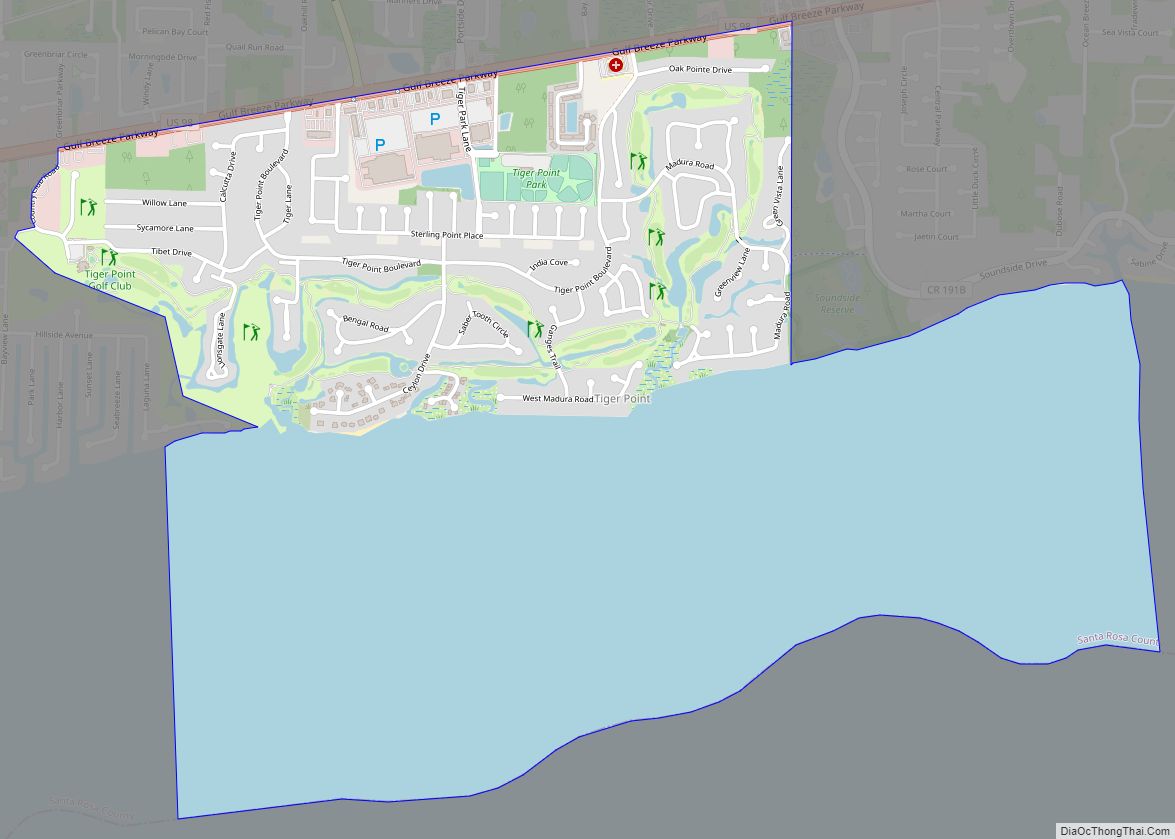
Tiger Point is a census-designated place in Santa Rosa County, Florida. It is considered to be a part of Gulf Breeze. The population was 3,090 as of the 2010 census. Tiger Point CDP overview: Name: Tiger Point CDP LSAD Code: 57 LSAD Description: CDP (suffix) State: Florida County: Santa Rosa County Elevation: 3 ft (0.9 m) Total … Read more

Map of Tierra Verde CDP

Map of Tierra Verde CDP, Florida

Tierra Verde is a census-designated place (CDP) in Pinellas County, Florida, United States. The population was 3,721 at the 2010 census. The community is located on an island near the entrance of Tampa Bay, and is connected by the bridges of the Pinellas Bayway to both St. Petersburg and St. Pete Beach. At the southern … Read more

Map of Tice CDP

Map of Tice CDP

Tice is an unincorporated community and census-designated place (CDP) in Lee County, Florida, United States. As of the 2020 census, the CDP population was 4,853. It is part of the Cape Coral-Fort Myers, Florida Metropolitan Statistical Area. Tice CDP overview: Name: Tice CDP LSAD Code: 57 LSAD Description: CDP (suffix) State: Florida County: Lee County … Read more

Map of Town 'n' Country CDP

Map of Town ‘n’ Country CDP

Town ‘n’ Country is a census-designated place (CDP) in Hillsborough County, Florida, United States. The population was 85,951 at the 2020 census. Within Town ‘n’ Country are located Bay Crest Park, Countryway, Rocky Creek, Sweetwater Creek. Town ‘n’ Country CDP overview: Name: Town ‘n’ Country CDP LSAD Code: 57 LSAD Description: CDP (suffix) State: Florida … Read more

Map of Timber Pines CDP

Map of Timber Pines CDP

Timber Pines is a census-designated place (CDP) in Hernando County, Florida, United States. The population was 5,386 at the 2010 census. Timber Pines CDP overview: Name: Timber Pines CDP LSAD Code: 57 LSAD Description: CDP (suffix) State: Florida County: Hernando County Elevation: 13 ft (4 m) Total Area: 2.28 sq mi (5.92 km²) Land Area: 2.20 sq mi (5.70 km²) Water Area: 0.09 sq mi … Read more

Map of Tildenville CDP

Map of Tildenville CDP

Tildenville is a census-designated place (CDP) and an unincorporated area in Orange County, Florida, United States. The population was 511 at the 2010 census. It is part of the Orlando–Kissimmee Metropolitan Statistical Area. Generally speaking, Tildenville is a narrow area alongside Orange County Road 545, south of Florida State Road 50 and north of the … Read more

Map of Trilby CDP

Map of Trilby CDP

Trilby is a census-designated place (CDP) in the northeast corner of Pasco County, Florida, United States. The population was 433 at the 2020 census. Trilby has a non-profit “Greater Trilby Community Association” which exists to improve the life and quality of residents of the Trilby, Trilacoochee and Lacoochee area. Trilby is the southernmost community along … Read more

Map of Trenton city

Map of Trenton city, Florida

Trenton is a city in Gilchrist County, Florida, United States. The population was 1,999 as of the 2010 census, and in 2018 it was estimated to be 2,125. It is the county seat of Gilchrist County. Trenton city overview: Name: Trenton city LSAD Code: 25 LSAD Description: city (suffix) State: Florida County: Gilchrist County Elevation: … Read more

Map of Treasure Island city

Map of Treasure Island city

Treasure Island is a city in Pinellas County, Florida, United States. It is situated on a barrier island in the Gulf of Mexico. As of the 2020 census, the city population was 6,584. Treasure Island city overview: Name: Treasure Island city LSAD Code: 25 LSAD Description: city (suffix) State: Florida County: Pinellas County Elevation: 3 ft … Read more

Map of Umatilla city

Map of Umatilla city, Florida

Umatilla is a city in Lake County, Florida, United States. The population was 3,456 at the 2010 census and an estimated 3,805 in 2018. Umatilla is known as the Gateway to the Ocala National Forest, located in northern Lake County. Umatilla city overview: Name: Umatilla city LSAD Code: 25 LSAD Description: city (suffix) State: Florida … Read more

Map of Tyndall AFB CDP

Map of Tyndall AFB CDP

Tyndall Air Force Base is a United States Air Force Base located 12 miles (19 km) east of Panama City, Florida. The base was named in honor of World War I pilot 1st Lt. Frank Benjamin Tyndall. The base operating unit and host wing is the 325th Fighter Wing (325 FW) of the Air Combat Command … Read more

Map of Trinity CDP, Florida

Map of Trinity CDP, Florida

Trinity is a census-designated place (CDP) in Pasco County, Florida, United States. The population was 10,907 in 2010, according to the most recent census. The Trinity Community is named after Trinity College of Florida, a Bible college founded in 1932, when it relocated to the first occupied site in the communities developed by James Gills … Read more