Map of Whiskey Creek CDP

Map of Whiskey Creek CDP

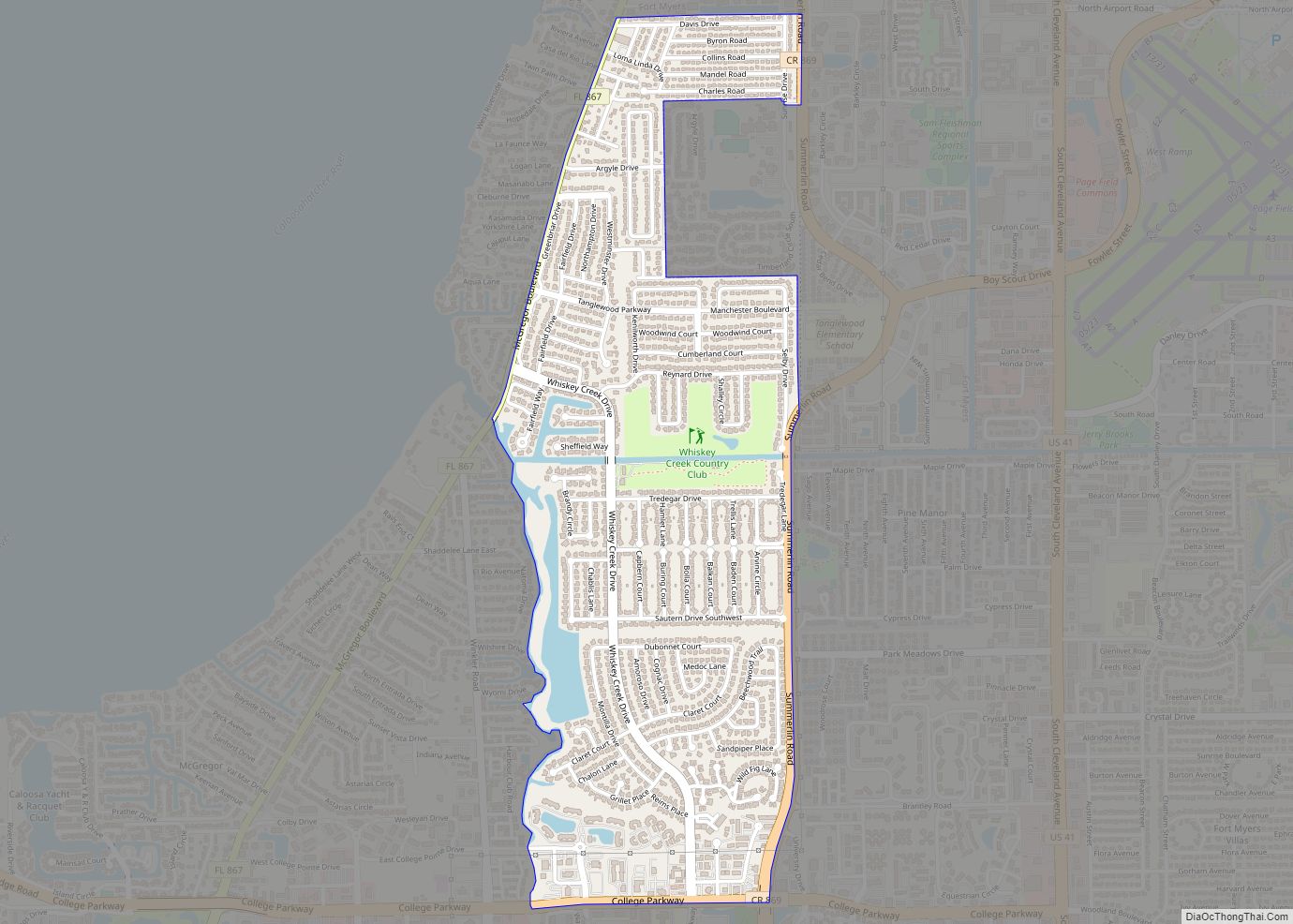
Whiskey Creek is a census-designated place (CDP) in Lee County, Florida, United States. The population was 4,842 at the 2020 census. It is part of the Cape Coral-Fort Myers, Florida Metropolitan Statistical Area. Whiskey Creek CDP overview: Name: Whiskey Creek CDP LSAD Code: 57 LSAD Description: CDP (suffix) State: Florida County: Lee County Elevation: 10 ft … Read more

Map of Wewahitchka city

Map of Wewahitchka city

Wewahitchka is a city in Gulf County, Florida, United States. The population was 2,074 as of the 2020 census. This was up from 1,722 as of the 2000 census. From the creation of Gulf County in 1925 until 1965, it served as the county seat before the county seat was moved to Port St. Joe. … Read more

Map of Westwood Lakes CDP

Map of Westwood Lakes CDP

Westwood Lakes is a census-designated place and unincorporated part of Miami-Dade County, Florida, United States. The population was 11,373 at the 2020 census. Westwood Lakes CDP overview: Name: Westwood Lakes CDP LSAD Code: 57 LSAD Description: CDP (suffix) State: Florida County: Miami-Dade County Elevation: 8 ft (2 m) Total Area: 1.80 sq mi (4.68 km²) Land Area: 1.66 sq mi (4.29 km²) Water … Read more

Map of Whitfield CDP

Map of Whitfield CDP, Florida

Whitfield, also known as Whitfield Estates, is an unincorporated community and census-designated place (CDP) in Manatee County, Florida, United States. As of the 2020 census it had a population of 2,989. It is part of the North Port–Sarasota–Bradenton Metropolitan Statistical Area. It receives its mail from the Sarasota post office located in Sarasota County. Whitfield … Read more

Map of White Springs town

Map of White Springs town

White Springs is a town in northern Florida on the Suwannee River. The population was 777 at the 2010 census, down from 819 at the 2000 census. Home of the annual Florida Folk Festival, it is a tourist destination noted for historic charm, antique shops and river recreation. White Springs town overview: Name: White Springs … Read more

Map of White City CDP

Map of White City CDP, Florida

White City is a census-designated place (CDP) in St. Lucie County, Florida, United States. The population was 3,719 at the 2010 census. It is part of the Port St. Lucie Metropolitan Statistical Area. White City CDP overview: Name: White City CDP LSAD Code: 57 LSAD Description: CDP (suffix) State: Florida County: St. Lucie County Elevation: … Read more

Map of Williston Highlands CDP

Map of Williston Highlands CDP

Williston Highlands is a census-designated place (CDP) in Levy County, Florida, United States. The population was 2,275 at the 2010 census. Williston Highlands CDP overview: Name: Williston Highlands CDP LSAD Code: 57 LSAD Description: CDP (suffix) State: Florida County: Levy County Elevation: 92 ft (28 m) Total Area: 11.32 sq mi (29.31 km²) Land Area: 11.32 sq mi (29.31 km²) Water Area: 0.00 sq mi … Read more

Map of Williamsburg CDP, Florida

Map of Williamsburg CDP, Florida

Williamsburg is a census-designated place (CDP) in Orange County, Florida, United States. The population was 7,646 at the 2010 census. It is part of the Orlando–Kissimmee Metropolitan Statistical Area. Williamsburg CDP overview: Name: Williamsburg CDP LSAD Code: 57 LSAD Description: CDP (suffix) State: Florida County: Orange County Elevation: 89 ft (27 m) Total Area: 3.65 sq mi (9.45 km²) Land … Read more

Map of Wildwood city

Map of Wildwood city, Florida

Wildwood is a city in Sumter County, Florida, United States. The population was 6,709 at the 2010 census. According to the U.S. Census Bureau’s 2018 estimates, the city had a population of 7,024. Due to rapid growth the city had over 33,000 residents by October of 2022 with plans to swell to over 100,000 in … Read more

Map of Williston city

Map of Williston city, Florida

Williston is a city in Levy County, Florida, United States. As of the 2010 census it had a population of 2,768. Williston city overview: Name: Williston city LSAD Code: 25 LSAD Description: city (suffix) State: Florida County: Levy County Elevation: 75 ft (23 m) Total Area: 6.84 sq mi (17.73 km²) Land Area: 6.83 sq mi (17.68 km²) Water Area: 0.02 sq mi (0.05 km²) Total … Read more

Map of Wilton Manors city

Map of Wilton Manors city

Wilton Manors is a city in Broward County, Florida, United States. As of the 2020 census, the city had a population of 11,426. Wilton Manors is part of the Miami metropolitan area, which was home to 6,166,488 people at the 2020 census. Wilton Manors city overview: Name: Wilton Manors city LSAD Code: 25 LSAD Description: … Read more

Map of Willow Oak CDP

Map of Willow Oak CDP

Willow Oak is a census-designated place (CDP) in western Polk County, Florida, United States. The population was 4,917 at the 2000 census. It is part of the Lakeland–Winter Haven Metropolitan Statistical Area. Willow Oak CDP overview: Name: Willow Oak CDP LSAD Code: 57 LSAD Description: CDP (suffix) State: Florida County: Polk County Elevation: 112 ft (34 m) … Read more