Map of Bolingbrook village
Bolingbrook is a village in Will and DuPage counties in the U.S. state of Illinois. It is a southwest suburb of Chicago on I-55 and Historic Route 66 (Frontage Road). The village was a new town built on the Gateway Wetlands west of the Des Plaines River in the 1960s. Bolingbrook experienced rapid growth in ... Read more
Map of Bolingbrook village
Map of Bluford village
Bluford is a village in Jefferson County, Illinois, in the United States. As of the 2010 census the village population was 688, down from 785 at the 2000 census. It is part of the Mount Vernon Micropolitan Statistical Area. Bluford village overview: Name: Bluford village LSAD Code: 47 LSAD Description: village (suffix) State: Illinois County: ... Read more
Map of Bluford village
Map of Bluffs village
Bluffs is a village in Scott County, Illinois, United States. The population was 715 at the 2010 census. It was briefly (1969–1971) the location of the WJJY TV Mast, the tallest structure (1,610 feet tall – 491 m) built to that date in Illinois. Bluffs is part of the Jacksonville Micropolitan Statistical Area. Bluffs village ... Read more
Map of Bluffs village
Map of Blue Mound village, Illinois
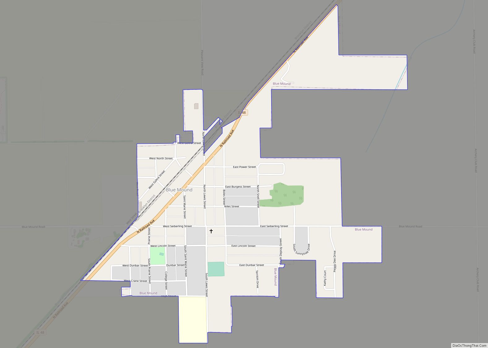
Blue Mound is a village in Macon County, Illinois, United States. The population was 1,133 at the 2020 census. It is included in the Decatur, Illinois Metropolitan Statistical Area. Blue Mound village overview: Name: Blue Mound village LSAD Code: 47 LSAD Description: village (suffix) State: Illinois County: Macon County Elevation: 616 ft (188 m) Total Area: 0.58 sq mi ... Read more
Map of Blue Mound village, Illinois
Map of Blue Island city
Blue Island is a city in Cook County, Illinois, located approximately 16 miles (26 km) south of Chicago’s Loop. Blue Island is adjacent to the city of Chicago and shares its northern boundary with that city’s Morgan Park neighborhood. The population was 22,558 at the 2020 United States Census. Blue Island was established in the 1830s ... Read more
Map of Blue Island city
Map of Bloomington city, Illinois
Bloomington is a city in and the county seat of McLean County, Illinois, United States. It is adjacent to the town of Normal, and is the more populous of the two principal municipalities of the Bloomington–Normal metropolitan area. Bloomington is 135 miles (217 km) southwest of Chicago and 162 miles (261 km) northeast of St. Louis. The ... Read more
Map of Bloomington city, Illinois
Map of Bloomingdale village, Illinois
Bloomingdale is a village in DuPage County, Illinois, United States, settled in 1833, and 25 miles northwest of downtown Chicago. The population was 22,382 at the 2020 census. Bloomingdale village overview: Name: Bloomingdale village LSAD Code: 47 LSAD Description: village (suffix) State: Illinois County: DuPage County Incorporated: 1889 Total Area: 7.03 sq mi (18.20 km²) Land Area: 6.77 sq mi ... Read more
Map of Bloomingdale village, Illinois
Map of Braceville village
Braceville is a village in Will County, Illinois, United States, with a portion in Grundy County. The population was 793 at the 2010 census. Braceville village overview: Name: Braceville village LSAD Code: 47 LSAD Description: village (suffix) State: Illinois County: Grundy County, Will County Total Area: 3.34 sq mi (8.65 km²) Land Area: 3.11 sq mi (8.06 km²) Water Area: 0.23 sq mi ... Read more
Map of Braceville village
Map of Bowen village
Bowen (formerly Bowensburg) is a village in southeast Hancock County, Illinois, United States. The population was 494 at the 2010 census. Bowen village overview: Name: Bowen village LSAD Code: 47 LSAD Description: village (suffix) State: Illinois County: Hancock County Elevation: 686 ft (209 m) Total Area: 0.43 sq mi (1.11 km²) Land Area: 0.43 sq mi (1.11 km²) Water Area: 0.00 sq mi (0.00 km²) Total ... Read more
Map of Bowen village
Map of Bourbonnais village
Bourbonnais (/ˌbʊərboʊˈneɪ, bɜːrˈboʊnɪs/ BOOR-boh-NAY, ) is a village in Kankakee County, Illinois, United States. The population was 18,164 at the 2020 census. Bourbonnais village overview: Name: Bourbonnais village LSAD Code: 47 LSAD Description: village (suffix) State: Illinois County: Kankakee County Elevation: 660 ft (200 m) Total Area: 9.31 sq mi (24.12 km²) Land Area: 9.31 sq mi (24.12 km²) Water Area: 0.00 sq mi (0.00 km²) ... Read more
Map of Bourbonnais village
Map of Boulder Hill CDP
Boulder Hill is a census-designated place (CDP) in Oswego Township, Kendall County, Illinois, United States. Per the 2020 census, the population was 8,394. It is part of the Chicago metropolitan area on the Fox River, south of Aurora. Boulder Hill CDP overview: Name: Boulder Hill CDP LSAD Code: 57 LSAD Description: CDP (suffix) State: Illinois ... Read more
Map of Boulder Hill CDP
Map of Boody CDP
Boody is an unincorporated community and census-designated place (CDP) in Macon County, Illinois, United States. As of the 2020 census, Boody had a population of 232, down from 276 in 2010. Boody has a post office with ZIP code 62514. The community was named after Col William H Boody. Boody CDP overview: Name: Boody CDP ... Read more
Map of Boody CDP