Map of DeKalb city

Map of DeKalb city

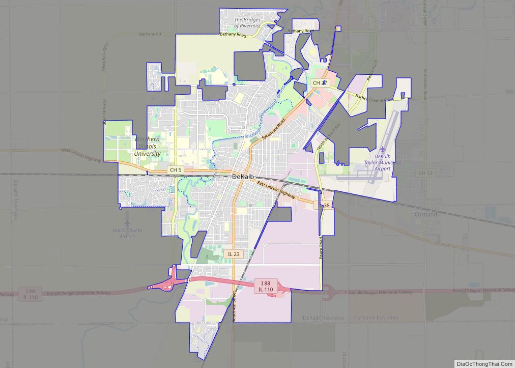
DeKalb (/dɪˈkælb/ dih-KALB) is a city in DeKalb County, Illinois, United States. The population was 40,290 at the 2020 census, down from 43,862 at the 2010 census. The city is named after decorated Franconian-French war hero Johann de Kalb, who died during the American Revolutionary War. Founded in 1856, DeKalb became important in the development … Read more

Map of Detroit village, Illinois

Map of Detroit village, Illinois

Detroit, Illinois is a village in Pike County, Illinois, United States. The population was 83 at the 2010 census, a decline from 93 in 2000. Detroit village overview: Name: Detroit village LSAD Code: 47 LSAD Description: village (suffix) State: Illinois County: Pike County Elevation: 640 ft (200 m) Total Area: 0.25 sq mi (0.65 km²) Land Area: 0.25 sq mi (0.65 km²) Water … Read more

Map of Des Plaines city

Map of Des Plaines city

Des Plaines /dɛs ˈpleɪnz/ is a city in Cook County, Illinois, United States. Per the 2020 census, the population was 60,675. The city is a suburb of Chicago and is located just north of O’Hare International Airport. It is situated on and is named after the Des Plaines River, which runs through the city just … Read more

Map of Dieterich village

Map of Dieterich village

Dieterich is a village in Effingham County, Illinois, United States. The population was 890 at the 2020 census. Dieterich is part of the Effingham, IL Micropolitan Statistical Area. Dieterich village overview: Name: Dieterich village LSAD Code: 47 LSAD Description: village (suffix) State: Illinois County: Effingham County Elevation: 594 ft (181 m) Total Area: 1.37 sq mi (3.54 km²) Land Area: … Read more

Map of Diamond village

Map of Diamond village, Illinois

Diamond is a village in Grundy and Will Counties, Illinois. The population was 2,527 at the 2010 census. Terry Kernc is the current mayor of Diamond. Diamond village overview: Name: Diamond village LSAD Code: 47 LSAD Description: village (suffix) State: Illinois County: Grundy County, Will County Elevation: 561 ft (171 m) Total Area: 1.90 sq mi (4.92 km²) Land Area: … Read more

Map of Dix village

Map of Dix village, Illinois

Dix is a village in Jefferson County, Illinois, United States. The population was 461 at the 2010 census. It is part of the Mount Vernon Micropolitan Statistical Area. Dix village overview: Name: Dix village LSAD Code: 47 LSAD Description: village (suffix) State: Illinois County: Jefferson County Elevation: 587 ft (179 m) Total Area: 2.08 sq mi (5.40 km²) Land Area: … Read more

Map of Divernon village

Map of Divernon village

Divernon is a village in Sangamon County, Illinois, United States. The population was 1,172 at the 2010 census, and 1,119 at a 2018 estimate. It is part of the Springfield, Illinois Metropolitan Statistical Area. Divernon village overview: Name: Divernon village LSAD Code: 47 LSAD Description: village (suffix) State: Illinois County: Sangamon County Elevation: 612 ft (187 m) … Read more

Map of Dixon city, Illinois

Map of Dixon city, Illinois

Dixon is a city and the county seat of Lee County, Illinois, United States. The population was 15,733 as of the 2010 census, down from 15,941 in 2000. The city is named after founder John Dixon, who operated a rope ferry service across the Rock River, which runs through the city. The Illinois General Assembly … Read more

Map of Dixmoor village

Map of Dixmoor village

Dixmoor (formerly Specialville) is a village in Cook County, Illinois, United States and a south suburb of Chicago. The population was 2,973 at the 2020 census. Dixmoor is adjacent to Harvey to the south & east, Posen to the west, and Blue Island & Riverdale to the north. Interstate 57 also runs through the village. … Read more

Map of Dongola village

Map of Dongola village

Dongola is a village in Union County, Illinois, United States. The population was 726 at the 2010 census. Dongola village overview: Name: Dongola village LSAD Code: 47 LSAD Description: village (suffix) State: Illinois County: Union County Elevation: 397 ft (121 m) Total Area: 1.15 sq mi (2.97 km²) Land Area: 1.09 sq mi (2.82 km²) Water Area: 0.06 sq mi (0.15 km²) Total Population: 661 Population … Read more

Map of Dolton village

Map of Dolton village, Illinois

Dolton (pronounced “DAWL-ton”) is a village in Cook County, Illinois, United States. The population was 21,426 at the 2020 census. Dolton is located just west of the expressway Interstate 94 and immediately south of the city limits of Chicago. Its most common ZIP code is 60419. Dolton is bordered by Chicago to the north, Riverdale … Read more

Map of Donovan village

Map of Donovan village

Donovan is a village in Beaver Township, Iroquois County, Illinois, United States. The population was 304 at the 2010 census. Donovan village overview: Name: Donovan village LSAD Code: 47 LSAD Description: village (suffix) State: Illinois County: Iroquois County Elevation: 673 ft (205 m) Total Area: 0.33 sq mi (0.85 km²) Land Area: 0.33 sq mi (0.85 km²) Water Area: 0.00 sq mi (0.00 km²) Total Population: … Read more