Map of East Hazel Crest village

Map of East Hazel Crest village

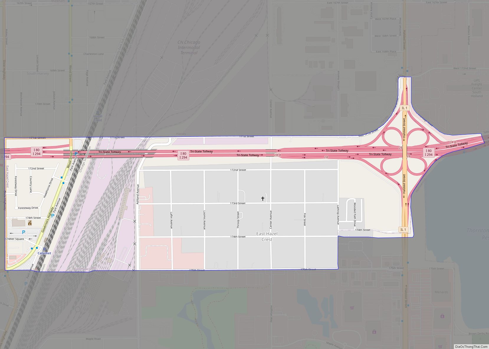
East Hazel Crest is a village in Cook County, Illinois, in the United States. It is a south suburb of Chicago. As of the 2020 census, the village population was 1,297. East Hazel Crest village overview: Name: East Hazel Crest village LSAD Code: 47 LSAD Description: village (suffix) State: Illinois County: Cook County Incorporated: 1928 … Read more

Map of East St. Louis city

Map of East St. Louis city

East St. Louis is a city in St. Clair County, Illinois. It is directly across the Mississippi River from Downtown St. Louis, Missouri and the Gateway Arch National Park. East St. Louis is in the Metro-East region of Southern Illinois. Once a bustling industrial center, like many cities in the Rust Belt, East St. Louis … Read more

Map of East Peoria city

Map of East Peoria city

East Peoria is a city in Tazewell County, Illinois, United States. The population was 22,484 at the 2020 census. East Peoria is a suburb of Peoria and is part of the Peoria, Illinois Metropolitan Statistical Area, located across the Illinois River from downtown Peoria. It is home to many Caterpillar Inc. facilities. The city is … Read more

Map of Eddyville village, Illinois

Map of Eddyville village, Illinois

Eddyville is a village in Pope County, Illinois, United States. The population was 153 at the 2000 census. Two designated wilderness areas, the Burden Falls Wilderness and the Lusk Creek Wilderness, are nearby. Eddyville village overview: Name: Eddyville village LSAD Code: 47 LSAD Description: village (suffix) State: Illinois County: Pope County Elevation: 682 ft (208 m) Total … Read more

Map of Easton village, Illinois

Map of Easton village, Illinois

Easton is a village in Mason County, Illinois, United States. As of the 2020 census, the village population was 312. Easton village overview: Name: Easton village LSAD Code: 47 LSAD Description: village (suffix) State: Illinois County: Mason County Elevation: 512 ft (156 m) Total Area: 0.24 sq mi (0.62 km²) Land Area: 0.24 sq mi (0.62 km²) Water Area: 0.00 sq mi (0.00 km²) Total Population: … Read more

Map of Edinburg village

Map of Edinburg village, Illinois

Edinburg is a village in Christian County, Illinois, United States. The population was 1,085 at the 2020 census. Edinburg village overview: Name: Edinburg village LSAD Code: 47 LSAD Description: village (suffix) State: Illinois County: Christian County Elevation: 597 ft (182 m) Total Area: 0.63 sq mi (1.62 km²) Land Area: 0.63 sq mi (1.62 km²) Water Area: 0.00 sq mi (0.00 km²) Total Population: 1,085 Population … Read more

Map of Edgewood village, Illinois

Map of Edgewood village, Illinois

Edgewood is a village in Effingham County, Illinois, United States. The population was 440 at the 2010 census, down from 527 at the 2000 census. Edgewood is part of the Effingham, IL Micropolitan Statistical Area. Edgewood village overview: Name: Edgewood village LSAD Code: 47 LSAD Description: village (suffix) State: Illinois County: Effingham County Elevation: 574 ft … Read more

Map of Effingham city

Map of Effingham city, Illinois

Effingham is a city in and the county seat of Effingham County, Illinois, United States. It is in South Central Illinois. Its population was 12,252 at the 2020 census. The city is part of the Effingham, IL Micropolitan Statistical Area. The city bills itself as “The Crossroads of Opportunity” because of its location at the … Read more

Map of Edwardsville city, Illinois

Map of Edwardsville city, Illinois

Edwardsville is a city in and the county seat of Madison County, Illinois, United States. As of the 2020 census, the population was 26,808. The city was named in honor of Ninian Edwards, then Governor of the Illinois Territory. Southern Illinois University Edwardsville, the Edwardsville Arts Center, the Edwardsville Journal, the Madison County Record, and … Read more

Map of El Paso city

Map of El Paso city, Illinois

El Paso is a city in Woodford and McLean counties in the U.S. state of Illinois. The population was 2,756 at the 2020 census. The Woodford County portion of El Paso is part of the Peoria Metropolitan Statistical Area. El Paso is a small community in central Illinois that took on more characteristics of a … Read more

Map of El Dara village

Map of El Dara village

El Dara is a village in Pike County, Illinois, United States. The population was 78 at the 2010 census, down from 89 in 2000. El Dara village overview: Name: El Dara village LSAD Code: 47 LSAD Description: village (suffix) State: Illinois County: Pike County Elevation: 738 ft (225 m) Total Area: 1.01 sq mi (2.62 km²) Land Area: 1.01 sq mi (2.62 km²) … Read more

Map of Eldorado city

Map of Eldorado city, Illinois

Eldorado (/ˌɛldəˈreɪdoʊ, -də/) is a city in Saline County, Illinois, United States. The population was 4,122 at the 2010 census, with a 1980 peak of 5,198. Although the city’s name is spelled as if it were Spanish, the name was originally “Eldereado” or “Elder-Reado” (depending on the source)—a combination of the last names of the … Read more