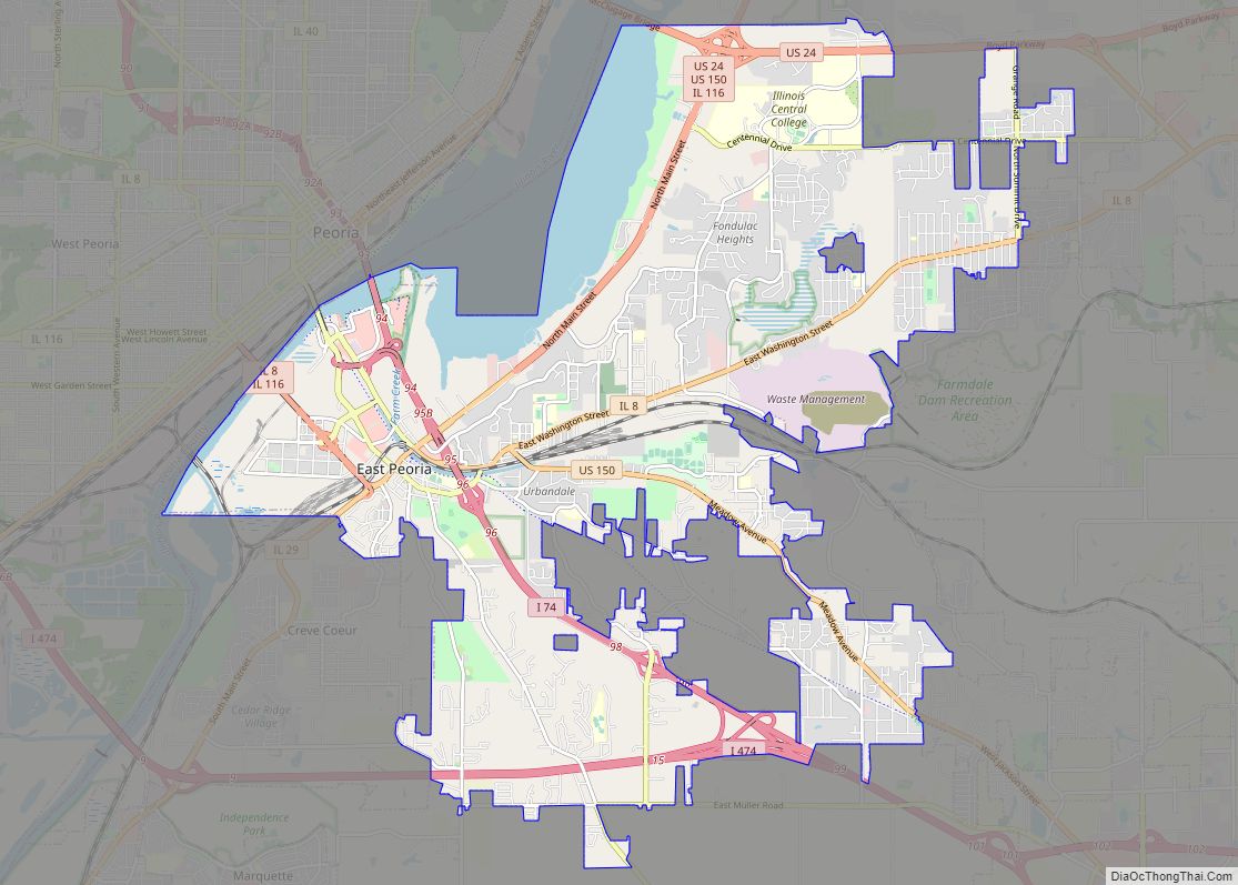
East Peoria is a city in Tazewell County, Illinois, United States. The population was 22,484 at the 2020 census. East Peoria is a suburb of Peoria and is part of the Peoria, Illinois Metropolitan Statistical Area, located across the Illinois River from downtown Peoria. It is home to many Caterpillar Inc. facilities.
The city is the site of the Par-A-Dice Hotel and Casino, as well as the city’s major business center- the Levee District. Located just east of the Illinois River, East Peoria has many points of access to and from the Peoria area. It is also the location of the Festival of Lights- an annual Christmas light display that runs from November to January and draws thousands of visitors from all over central Illinois.
| Name: | East Peoria city |
|---|---|
| LSAD Code: | 25 |
| LSAD Description: | city (suffix) |
| State: | Illinois |
| County: | Tazewell County |
| Founded: | July 1884 |
| Elevation: | 499 ft (152 m) |
| Total Area: | 22.71 sq mi (58.81 km²) |
| Land Area: | 20.41 sq mi (53.57 km²) |
| Water Area: | 1.73 sq mi (5.24 km²) |
| Total Population: | 22,484 |
| Population Density: | 1,087.02/sq mi (419.70/km²) |
| Area code: | 309 |
| FIPS code: | 1722164 |
| Website: | www.cityofeastpeoria.com |
Online Interactive Map
Click on ![]() to view map in "full screen" mode.
to view map in "full screen" mode.
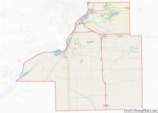
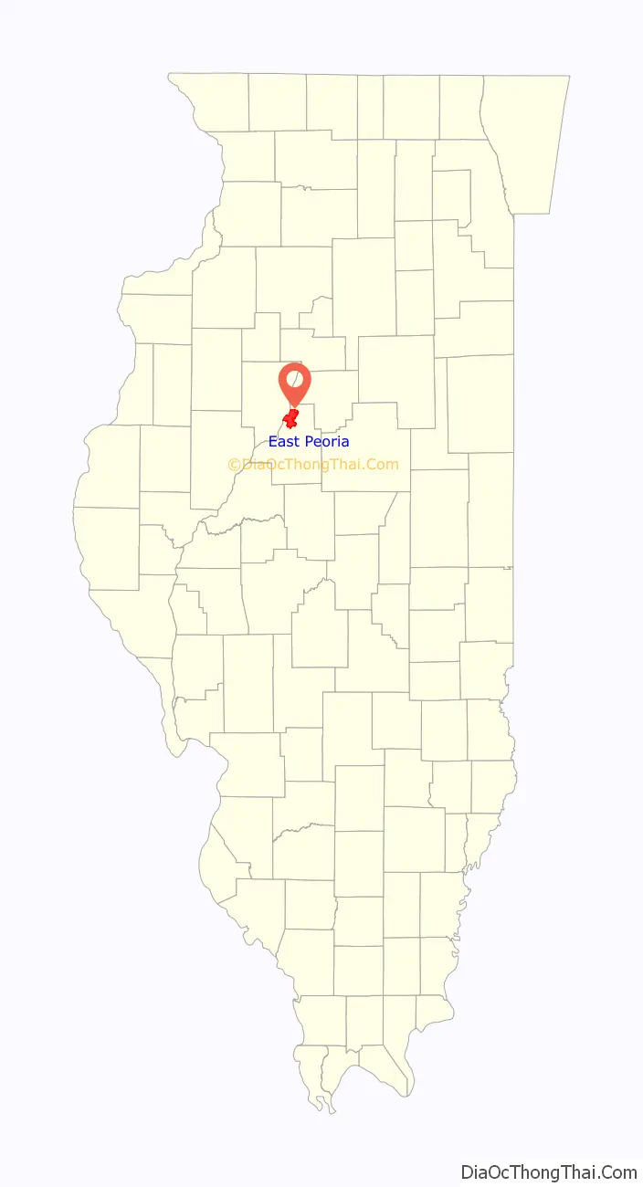
East Peoria location map. Where is East Peoria city?

History
Several years after Illinois became a state (which happened December 18, 1818), William Blanchard and three other men (Charles Sargeant, Theodore Sargeant, and David Barnes) crossed Fort Clark (located in Peoria) to the eastern side of the Illinois River. The land here was a swampy floodplain- nevertheless, they made their claim on the land and built huts, growing corn and tomatoes in the fertile soil. This settlement was originally named “Fondulac Township”, with fondulac meaning “bottom of the lake” in French.
Over the course of a few years, more settlers arrived. Jacob L. Wilson, Thomas Camelin, and a man simply known as “Donohue” established themselves in the new township, with Wilson eventually becoming the Justice of the Peace.
On June 14, 1855, a petition to plat the Town of Fondulac was filed with Tenth Judicial Circuit Court by Seth Abbott. This plat showed three streets—Mill Street, Main Street, and Depot Avenue—in addition to a saw mill, a cording mill, and a portion of the Peoria & Oquawka Railroad. By 1857, the Peoria & Oquawka Railroad was completed as far east as Chenoa, and the town received and sent farm products by rail. In February of 1864, an additional plat of land was laid out for a town named “Bluetown” by William C. Cleveland, who was the Tazewell County Surveyor. This plat showed four streets- Peoria Street, Bloomington Street, Vine Street, and Sycamore Street. The petition for this plat was filed by Joseph Schertz and accepted April 1, 1864. The origins of the name “Bluetown” are claimed to be from Joseph Schertz, who “always wore blue smocks at their work.”
On July 1, 1884, citizens of both Fondulac and Bluetown held a referendum at the public school- they proposed both towns be incorporated as one. This proposition passed by a vote of 30-12, and the two towns were merged into the Village of Hilton. There is no official origin behind the new name, but there is a connection with the Hilton Coal & Iron Mining Co. at the eastern end of town. On August 4th, the first village Board of Trustees was elected. Nicholas Slagle was named the first president, and he appointed Thomas J. Floyd and Joseph Moseman as the village clerk and treasurer, respectively. Peter Schertz, H.F. Cappo, J.G. Vogelgesang, Samuel Allen Sr., and Edward Lange Sr. were elected to the board as well.
The village existed as Hilton for five years. In October, 1889, the name was changed to the “Village of East Peoria”, since it was east of the city of Peoria. The name underwent a final change in April of 1919, when it became the “City of East Peoria”.
East Peoria Road Map
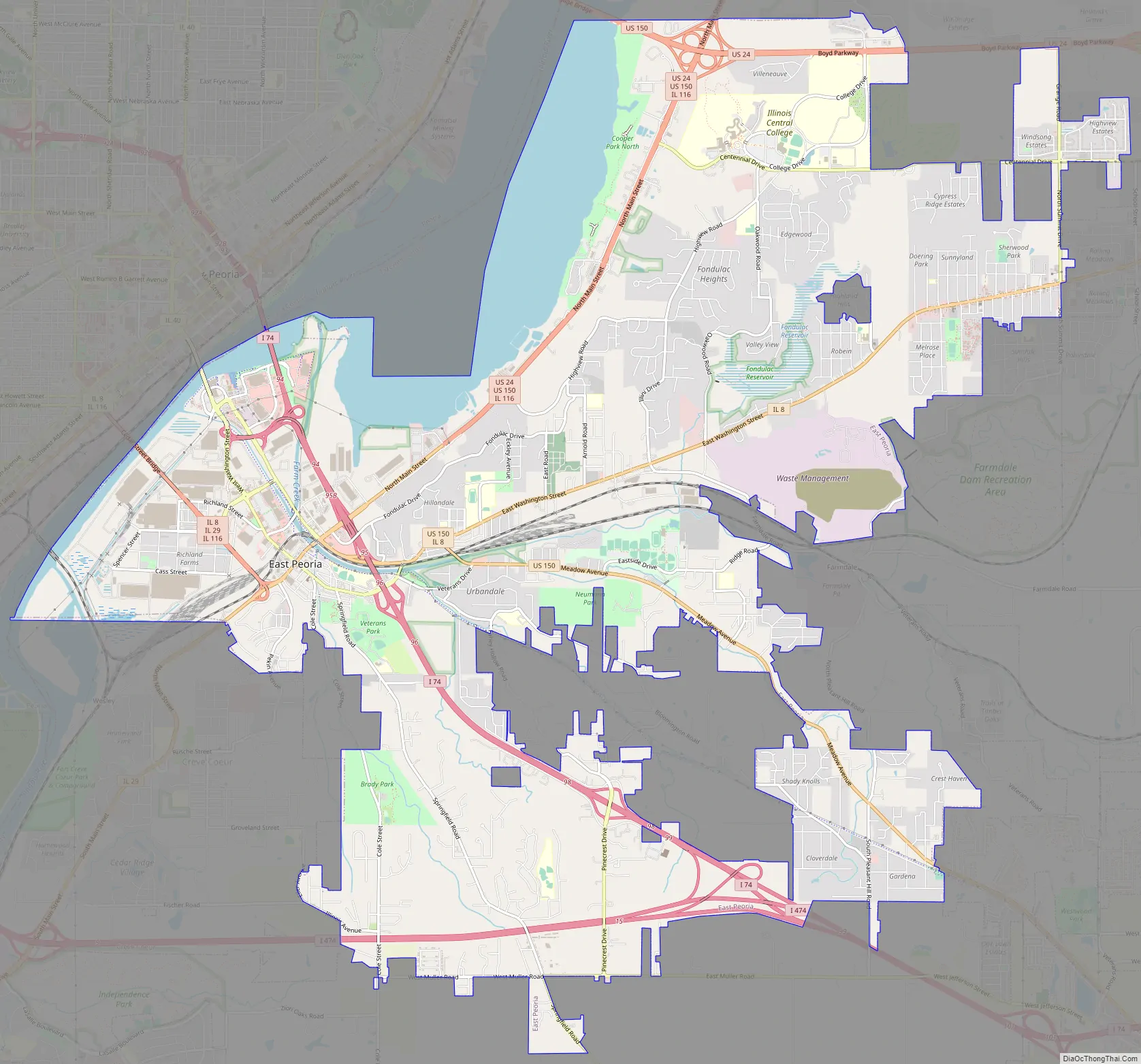
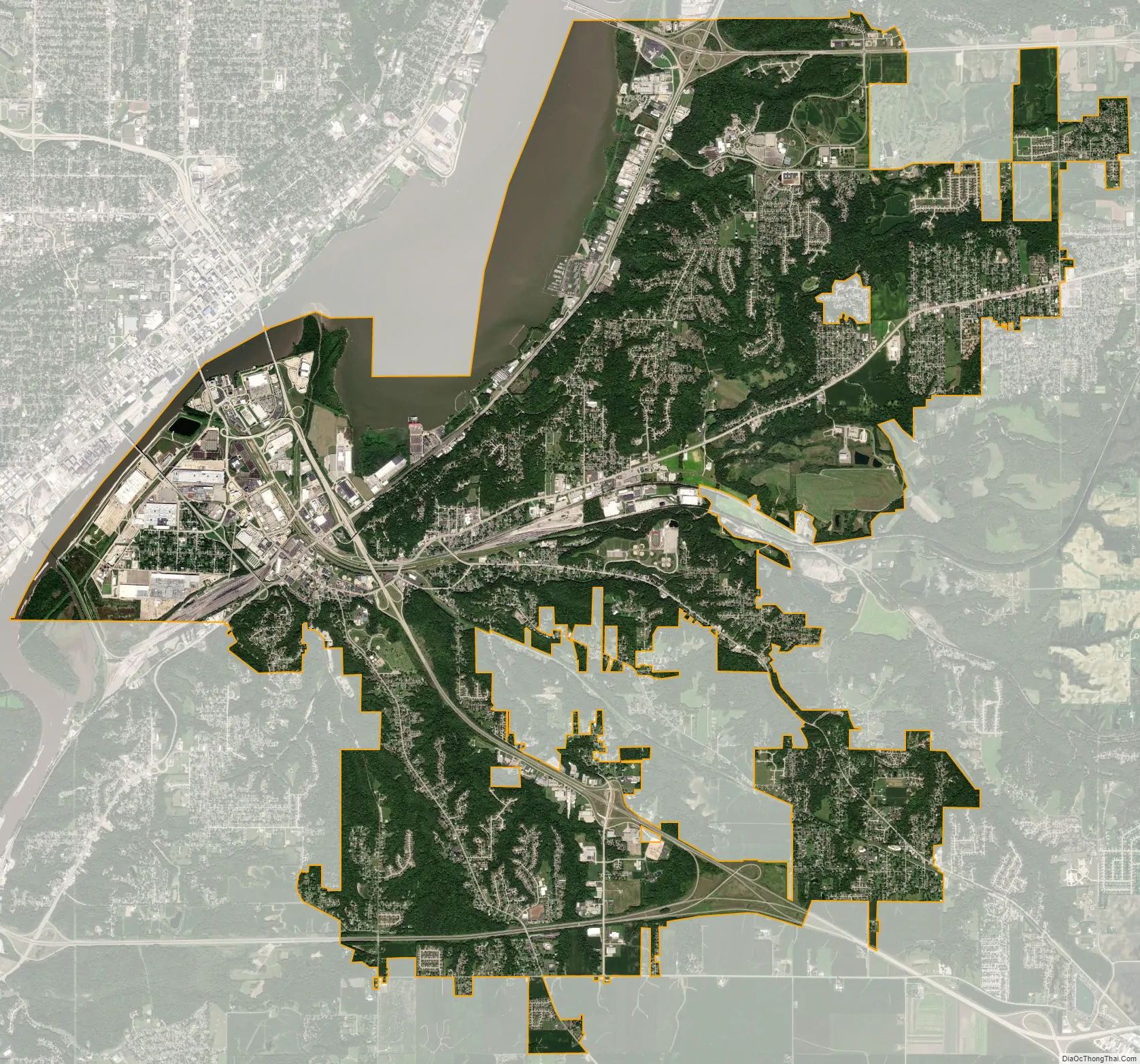
East Peoria city Satellite Map
Geography
According to the 2020 census, East Peoria has a total area of 22.147 square miles (57.36 km), of which 20.41 square miles (52.86 km) (or 90.13%) is land and 1.73 square miles (4.48 km) (or 9.87%) is water.
Climate
See also
Map of Illinois State and its subdivision:- Adams
- Alexander
- Bond
- Boone
- Brown
- Bureau
- Calhoun
- Carroll
- Cass
- Champaign
- Christian
- Clark
- Clay
- Clinton
- Coles
- Cook
- Crawford
- Cumberland
- De Kalb
- De Witt
- Douglas
- Dupage
- Edgar
- Edwards
- Effingham
- Fayette
- Ford
- Franklin
- Fulton
- Gallatin
- Greene
- Grundy
- Hamilton
- Hancock
- Hardin
- Henderson
- Henry
- Iroquois
- Jackson
- Jasper
- Jefferson
- Jersey
- Jo Daviess
- Johnson
- Kane
- Kankakee
- Kendall
- Knox
- La Salle
- Lake
- Lake Michigan
- Lawrence
- Lee
- Livingston
- Logan
- Macon
- Macoupin
- Madison
- Marion
- Marshall
- Mason
- Massac
- McDonough
- McHenry
- McLean
- Menard
- Mercer
- Monroe
- Montgomery
- Morgan
- Moultrie
- Ogle
- Peoria
- Perry
- Piatt
- Pike
- Pope
- Pulaski
- Putnam
- Randolph
- Richland
- Rock Island
- Saint Clair
- Saline
- Sangamon
- Schuyler
- Scott
- Shelby
- Stark
- Stephenson
- Tazewell
- Union
- Vermilion
- Wabash
- Warren
- Washington
- Wayne
- White
- Whiteside
- Will
- Williamson
- Winnebago
- Woodford
- Alabama
- Alaska
- Arizona
- Arkansas
- California
- Colorado
- Connecticut
- Delaware
- District of Columbia
- Florida
- Georgia
- Hawaii
- Idaho
- Illinois
- Indiana
- Iowa
- Kansas
- Kentucky
- Louisiana
- Maine
- Maryland
- Massachusetts
- Michigan
- Minnesota
- Mississippi
- Missouri
- Montana
- Nebraska
- Nevada
- New Hampshire
- New Jersey
- New Mexico
- New York
- North Carolina
- North Dakota
- Ohio
- Oklahoma
- Oregon
- Pennsylvania
- Rhode Island
- South Carolina
- South Dakota
- Tennessee
- Texas
- Utah
- Vermont
- Virginia
- Washington
- West Virginia
- Wisconsin
- Wyoming