Map of Grayville city
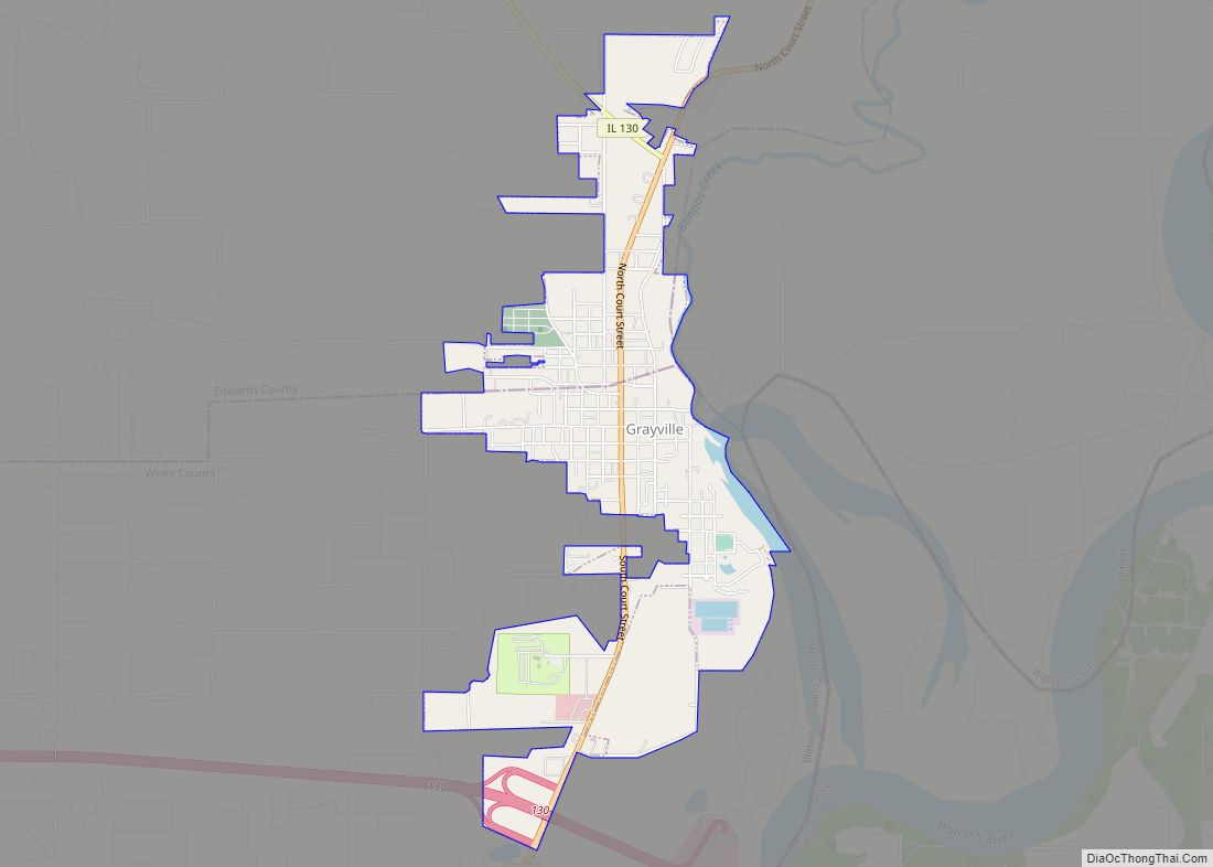
Grayville is a city in Edwards and White counties in the U.S. state of Illinois. As of the 2020 census, the city’s population was 1,550, down from 1,666 at the 2010 census. Grayville is the birthplace of naval hero James Meredith Helm. Grayville city overview: Name: Grayville city LSAD Code: 25 LSAD Description: city (suffix) ... Read more
Map of Grayville city
Map of Greenfield city, Illinois
Greenfield is a city in Greene County, Illinois, United States. The population was 1,071 at the 2010 census. Greenfield city overview: Name: Greenfield city LSAD Code: 25 LSAD Description: city (suffix) State: Illinois County: Greene County Elevation: 581 ft (177 m) Total Area: 1.78 sq mi (4.60 km²) Land Area: 1.71 sq mi (4.44 km²) Water Area: 0.06 sq mi (0.16 km²) Total Population: 1,059 Population ... Read more
Map of Greenfield city, Illinois
Map of Green Valley village, Illinois
Green Valley is a village in Tazewell County, Illinois, United States. It is south of Pekin near the county border along Illinois State Route 29. The population was 709 at the 2010 census Green Valley village overview: Name: Green Valley village LSAD Code: 47 LSAD Description: village (suffix) State: Illinois County: Tazewell County Elevation: 535 ft ... Read more
Map of Green Valley village, Illinois
Map of Greenview village, Illinois
Greenview is a village in Menard County, Illinois, United States. The population was 745 at the 2020 census. It is part of the Springfield, Illinois Metropolitan Statistical Area. Greenview village overview: Name: Greenview village LSAD Code: 47 LSAD Description: village (suffix) State: Illinois County: Menard County Elevation: 538 ft (164 m) Total Area: 0.86 sq mi (2.23 km²) Land Area: ... Read more
Map of Greenview village, Illinois
Map of Greenup village, Illinois
Greenup is a village in Cumberland County, Illinois, United States, along the Embarras River. The population was 1,365 at the 2020 census. It is part of the Charleston–Mattoon Micropolitan Statistical Area. Greenup received its name from National Road surveyor, William C. Greenup who platted the town in 1834. He was one of the supervisors hired ... Read more
Map of Greenup village, Illinois
Map of Greenwood village, Illinois
Greenwood is a village in McHenry County, Illinois, United States. It is a commuter village, part of the Chicago metropolitan area It was incorporated as a village on 4 April 1995. The population was 324 at the 2020 census. Greenwood village overview: Name: Greenwood village LSAD Code: 47 LSAD Description: village (suffix) State: Illinois County: ... Read more
Map of Greenwood village, Illinois
Map of Greenville city, Illinois
Greenville is a city in Bond County, Illinois, United States, 51 miles (82 km) east of St. Louis. The population as of the 2020 census was 7,083, up from 7,000 at the 2010 census. It is the county seat of Bond County. Greenville is part of the St. Louis Metropolitan Statistical Area. It is also considered ... Read more
Map of Greenville city, Illinois
Map of Griggsville city
Griggsville is a city in Pike County, Illinois, United States. The population was 1,226 at the 2010 census. Griggsville city overview: Name: Griggsville city LSAD Code: 25 LSAD Description: city (suffix) State: Illinois County: Pike County Elevation: 705 ft (215 m) Total Area: 1.11 sq mi (2.86 km²) Land Area: 1.11 sq mi (2.86 km²) Water Area: 0.00 sq mi (0.00 km²) Total Population: 1,097 Population ... Read more
Map of Griggsville city
Map of Gridley village, Illinois
Gridley is a village in McLean County, Illinois, United States. The population was 1,456 at the 2020 census. It is part of the Bloomington–Normal Metropolitan Statistical Area. The village of Gridley was founded in 1869 and named after General Asahel Gridley, a noted early Republican, land investor, political backer and client of Abraham Lincoln, and ... Read more
Map of Gridley village, Illinois
Map of Gurnee village
Gurnee (/ˈɡɜːrˌniː/ GUR-nee) is a village in Lake County, Illinois, United States. Its population was 30,706 as of the 2020 census. It borders the city of Waukegan, and is a popular tourist attraction within the Chicago metropolitan area. Best known for being the location of Six Flags Great America, Six Flags Hurricane Harbor Chicago and ... Read more
Map of Gurnee village
Map of Gulf Port village
Gulf Port village overview: Name: Gulf Port village LSAD Code: 47 LSAD Description: village (suffix) State: Illinois County: Henderson County FIPS code: 1731992 Online Interactive Map Gulf Port online map. Source: Basemap layers from Google Map, Open Street Map (OSM), Arcgisonline, Wmflabs. Boundary Data from Database of Global Administrative Areas. Gulf Port location map. Where ... Read more
Map of Gulf Port village
Map of Hamburg village, Illinois
Hamburg is a village in Calhoun County, Illinois, United States. The population was 99 at the 2020 census, down from 128 at the 2010 census. Hamburg village overview: Name: Hamburg village LSAD Code: 47 LSAD Description: village (suffix) State: Illinois County: Calhoun County Elevation: 554 ft (169 m) Total Area: 0.656 sq mi (1.70 km²) Land Area: 0.522 sq mi (1.35 km²) Water ... Read more
Map of Hamburg village, Illinois