Map of Hazel Crest village
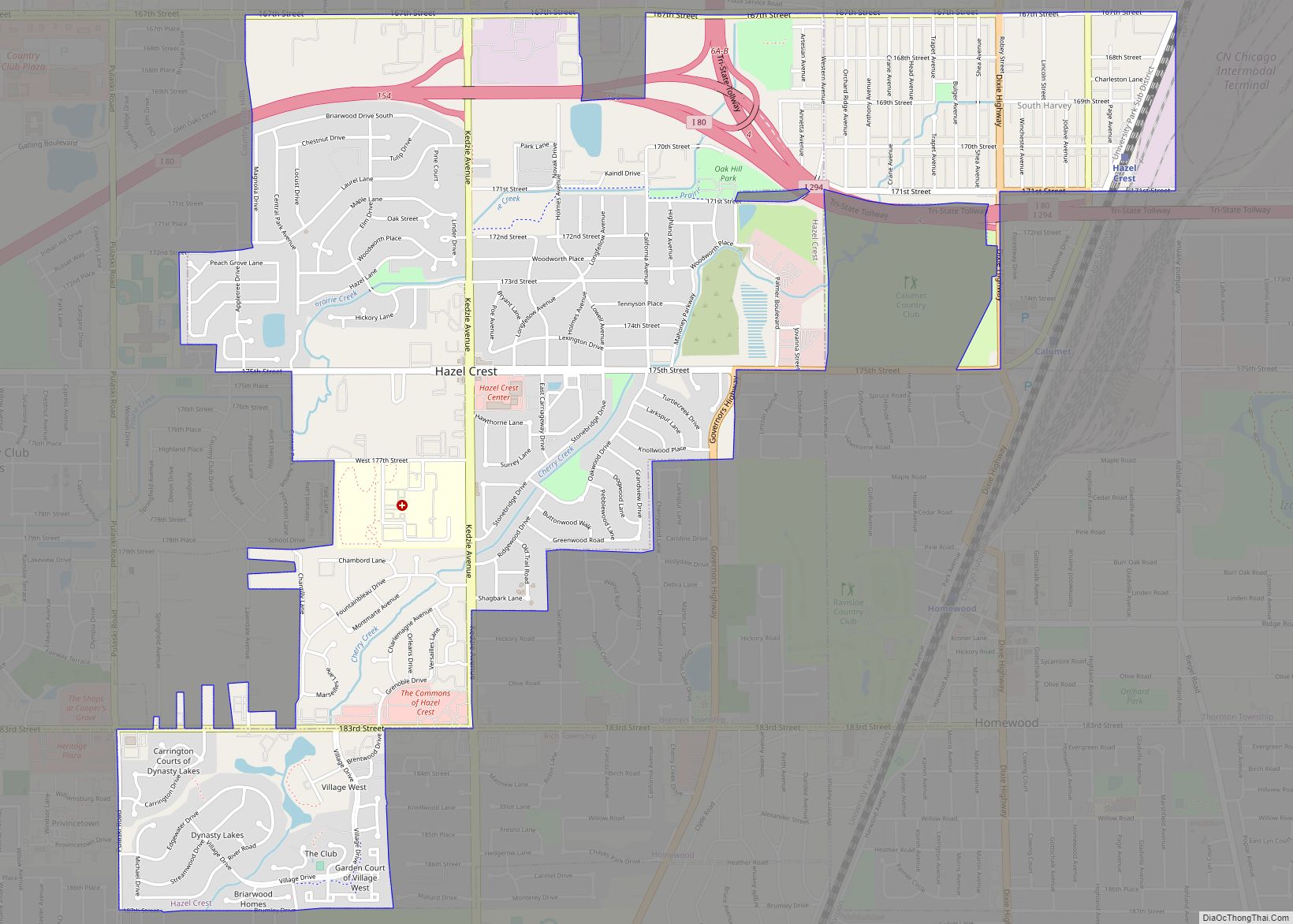
Hazel Crest is a village in Cook County, Illinois, United States. The population was 13,382 at the 2020 census. Hazel Crest village overview: Name: Hazel Crest village LSAD Code: 47 LSAD Description: village (suffix) State: Illinois County: Cook County Incorporated: 1911 Total Area: 3.42 sq mi (8.85 km²) Land Area: 3.40 sq mi (8.80 km²) Water Area: 0.02 sq mi (0.05 km²)  0.59% Total ... Read more
Map of Hazel Crest village
Map of Henderson village, Illinois
Henderson is a village in Knox County, Illinois, United States. The population was 255 at the 2010 census, down from 319 at the 2000 census. It is part of the Galesburg Micropolitan Statistical Area. Henderson village overview: Name: Henderson village LSAD Code: 47 LSAD Description: village (suffix) State: Illinois County: Knox County Elevation: 817 ft (249 m) ... Read more
Map of Henderson village, Illinois
Map of Hecker village
Hecker is a village in Monroe County in the U.S state of Illinois. The population was 429 at the 2020 census, down from 481 in 2010. Hecker village overview: Name: Hecker village LSAD Code: 47 LSAD Description: village (suffix) State: Illinois County: Monroe County, St. Clair County Founded: 1895 Elevation: 476 ft (145 m) Total Area: 0.26 sq mi ... Read more
Map of Hecker village
Map of Henning village, Illinois
Henning is a village in South Ross Township, Vermilion County, Illinois, United States. It is part of the Danville, Illinois Metropolitan Statistical Area. The population was 241 at the 2000 census. Henning village overview: Name: Henning village LSAD Code: 47 LSAD Description: village (suffix) State: Illinois County: Vermilion County Incorporated: 1903 Elevation: 686 ft (209 m) Total ... Read more
Map of Henning village, Illinois
Map of Hennepin village
Hennepin is a village located on the Illinois River in Putnam County, Illinois, United States. The population was 757 in 2010, an increase of 50 since the 2000 census. It is the county seat and second largest village in Putnam County. Hennepin is part of the Ottawa Micropolitan Statistical Area. Hennepin village overview: Name: Hennepin ... Read more
Map of Hennepin village
Map of Heritage Lake CDP, Illinois
Heritage Lake is a census-designated place in Tazewell County, Illinois, United States. Its population was 1,520 as of the 2010 census. Heritage Lake CDP overview: Name: Heritage Lake CDP LSAD Code: 57 LSAD Description: CDP (suffix) State: Illinois County: Tazewell County Elevation: 742 ft (226 m) Total Area: 1.25 sq mi (3.25 km²) Land Area: 1.14 sq mi (2.95 km²) Water Area: 0.12 sq mi ... Read more
Map of Heritage Lake CDP, Illinois
Map of Henry city, Illinois
Henry is a city in Marshall County, Illinois, United States. The population was 2,320 at the 2020 census. It is part of the Peoria Metropolitan Statistical Area. Henry city overview: Name: Henry city LSAD Code: 25 LSAD Description: city (suffix) State: Illinois County: Marshall County Elevation: 487 ft (148 m) Total Area: 1.87 sq mi (4.84 km²) Land Area: 1.80 sq mi ... Read more
Map of Henry city, Illinois
Map of Herrin city
Herrin is a city in Williamson County, Illinois. The population was 12,352 at the 2020 census. The city is part of the Marion-Herrin Micropolitan Area and is a part of the Carbondale–Marion-Herrin, Illinois Combined Statistical Area with 123,272 residents, the sixth most populous Combined statistical area in Illinois. Herrin city overview: Name: Herrin city LSAD ... Read more
Map of Herrin city
Map of Herrick village, Illinois
Herrick is a village in Shelby County, Illinois, United States. The population was 436 at the 2010 census. According to the 2010 census, Herrick has a total area of 0.37 square miles (0.96 km), all land. Herrick village overview: Name: Herrick village LSAD Code: 47 LSAD Description: village (suffix) State: Illinois County: Shelby County Elevation: 596 ft ... Read more
Map of Herrick village, Illinois
Map of Hettick village
Hettick is a village in Macoupin County, Illinois, United States. The population was 149 at the 2020 census, down from 181 in 2010. Hettick village overview: Name: Hettick village LSAD Code: 47 LSAD Description: village (suffix) State: Illinois County: Macoupin County Elevation: 596 ft (182 m) Total Area: 0.36 sq mi (0.95 km²) Land Area: 0.36 sq mi (0.95 km²) Water Area: 0.00 sq mi ... Read more
Map of Hettick village
Map of Herscher village
Herscher is a village in Kankakee County, Illinois, United States. The population was 1,521 at the 2020 census. It is part of the Kankakee–Bradley metropolitan area. Herscher village overview: Name: Herscher village LSAD Code: 47 LSAD Description: village (suffix) State: Illinois County: Kankakee County Elevation: 655 ft (200 m) Total Area: 1.81 sq mi (4.70 km²) Land Area: 1.81 sq mi (4.70 km²) ... Read more
Map of Herscher village
Map of Hickory Hills city, Illinois
Hickory Hills is a city in Cook County, Illinois. Located principally in Palos Township, it is a suburb of Chicago. The population in 2020 was 14,505. Hickory Hills city overview: Name: Hickory Hills city LSAD Code: 25 LSAD Description: city (suffix) State: Illinois County: Cook County Incorporated: 1951 Elevation: 680 ft (210 m) Total Area: 2.84 sq mi (7.37 km²) ... Read more
Map of Hickory Hills city, Illinois