Map of Staunton city

Map of Staunton city, Illinois

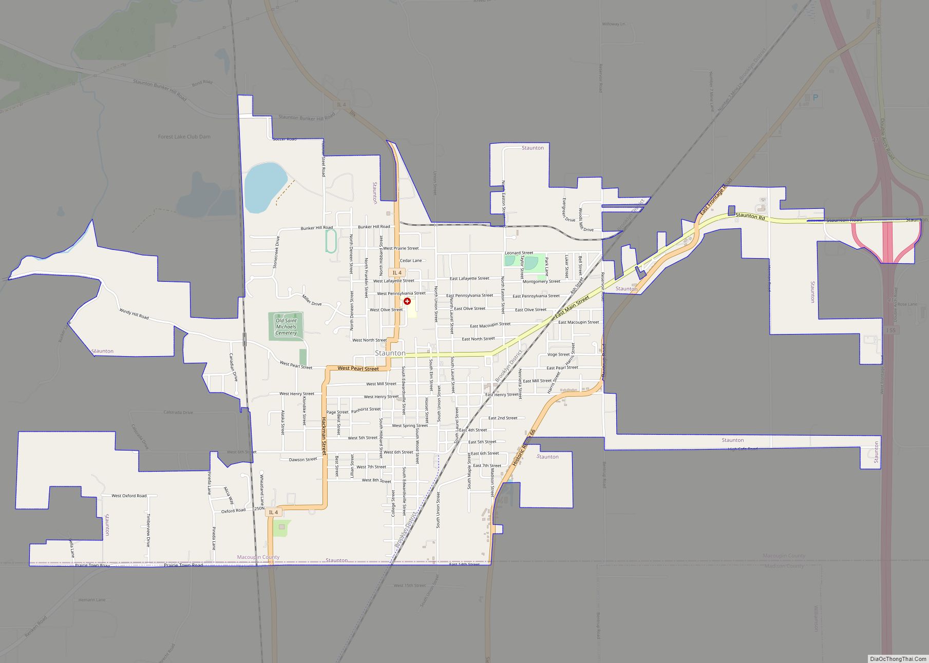
Staunton is the second largest city in Macoupin County, Illinois, United States. As of the 2020 census, the population was 5,054. Staunton city overview: Name: Staunton city LSAD Code: 25 LSAD Description: city (suffix) State: Illinois County: Macoupin County Elevation: 623 ft (190 m) Total Area: 4.01 sq mi (10.38 km²) Land Area: 3.97 sq mi (10.29 km²) Water Area: 0.04 sq mi (0.09 km²) Total … Read more

Map of Steger village

Map of Steger village

Steger is a village that straddles the border which separates Cook County and Will County, Illinois (Steger Road is the border line). It is 35 miles (56 km) south of Chicago and had a population of 9,584 at the 2020 census. Steger village overview: Name: Steger village LSAD Code: 47 LSAD Description: village (suffix) State: Illinois … Read more

Map of Steeleville village

Map of Steeleville village

Steeleville is a village in Randolph County, Illinois, United States. The population was 2,083 at the 2010 census. Steeleville village overview: Name: Steeleville village LSAD Code: 47 LSAD Description: village (suffix) State: Illinois County: Randolph County Elevation: 420 ft (130 m) Total Area: 1.53 sq mi (3.97 km²) Land Area: 1.52 sq mi (3.95 km²) Water Area: 0.01 sq mi (0.02 km²) Total Population: 1,930 Population … Read more

Map of Steward village

Map of Steward village

Steward is a village in Lee County, Illinois, United States. The population was 256 at the 2010 census, down from 271 in 2000. Steward village overview: Name: Steward village LSAD Code: 47 LSAD Description: village (suffix) State: Illinois County: Lee County Total Area: 0.13 sq mi (0.34 km²) Land Area: 0.13 sq mi (0.34 km²) Water Area: 0.00 sq mi (0.00 km²) Total Population: … Read more

Map of Sterling city, Illinois

Map of Sterling city, Illinois

Sterling is a city in Whiteside County, Illinois, United States. The population was 14,782 at the 2020 census, down from 15,370 in 2010. Formerly nicknamed “Hardware Capital of the World”, the city has long been associated with manufacturing and the steel industry. Sterling city overview: Name: Sterling city LSAD Code: 25 LSAD Description: city (suffix) … Read more

Map of Stickney village

Map of Stickney village, Illinois

Stickney is a village in Cook County, Illinois, United States. The village is named for Alpheus Beede Stickney, a railroad executive who played a central role in establishing the Clearing Industrial District. Per the 2020 census, the population was 7,110. It was well known in the 1920s and early 1930s as the home for several … Read more

Map of Stewardson village

Map of Stewardson village

Stewardson is a village in Shelby County, Illinois, United States. The population was 734 at the 2010 census. Stewardson village overview: Name: Stewardson village LSAD Code: 47 LSAD Description: village (suffix) State: Illinois County: Shelby County Elevation: 646 ft (197 m) Total Area: 0.61 sq mi (1.58 km²) Land Area: 0.61 sq mi (1.58 km²) Water Area: 0.00 sq mi (0.00 km²) Total Population: 721 Population … Read more

Map of Stockton village, Illinois

Map of Stockton village, Illinois

Stockton is a village in Jo Daviess County, Illinois, United States. The population was 1,862 at the 2010 census, down from 1,926 at the 2000 census. Stockton village overview: Name: Stockton village LSAD Code: 47 LSAD Description: village (suffix) State: Illinois County: Jo Daviess County Elevation: 994 ft (303 m) Total Area: 1.88 sq mi (4.86 km²) Land Area: 1.88 sq mi … Read more

Map of Stillman Valley village

Map of Stillman Valley village

Stillman Valley is a village in Marion Township, Ogle County, Illinois, United States. It lies east of Byron, south of Rockford and west of Davis Junction. The population was 1,120 at the 2010 census, up from 1,048 in 2000. The village is located on the Iowa, Chicago and Eastern Railroad, on the old Chicago Great … Read more

Map of Stonefort village

Map of Stonefort village

Stonefort is a village in Saline and Williamson Counties, Illinois, United States. The population was 297 at the 2010 census. Stonefort village overview: Name: Stonefort village LSAD Code: 47 LSAD Description: village (suffix) State: Illinois County: Saline County, Williamson County Elevation: 404 ft (123 m) Total Area: 1.46 sq mi (3.78 km²) Land Area: 1.45 sq mi (3.77 km²) Water Area: 0.01 sq mi (0.01 km²) … Read more

Map of Stone Park village

Map of Stone Park village

Stone Park is a village in Cook County, Illinois, United States. The population was 4,576 at the 2020 census. Incorporated in 1939, the town was named for insurance magnate Clement Stone, who bought most of the land when it was still corn fields. Stone Park village overview: Name: Stone Park village LSAD Code: 47 LSAD … Read more

Map of Stoy village

Map of Stoy village

Stoy is a village in Crawford County, Illinois, United States. The population was 108 at the 2020 census. Stoy village overview: Name: Stoy village LSAD Code: 47 LSAD Description: village (suffix) State: Illinois County: Crawford County Elevation: 466 ft (142 m) Total Area: 0.93 sq mi (2.42 km²) Land Area: 0.93 sq mi (2.42 km²) Water Area: 0.00 sq mi (0.00 km²)  0% Total Population: 108 … Read more