Staunton is the second largest city in Macoupin County, Illinois, United States. As of the 2020 census, the population was 5,054.
| Name: | Staunton city |
|---|---|
| LSAD Code: | 25 |
| LSAD Description: | city (suffix) |
| State: | Illinois |
| County: | Macoupin County |
| Elevation: | 623 ft (190 m) |
| Total Area: | 4.01 sq mi (10.38 km²) |
| Land Area: | 3.97 sq mi (10.29 km²) |
| Water Area: | 0.04 sq mi (0.09 km²) |
| Total Population: | 5,054 |
| Population Density: | 1,271.77/sq mi (491.04/km²) |
| ZIP code: | 62088 |
| Area code: | 618 |
| FIPS code: | 1772403 |
| GNISfeature ID: | 2395959 |
| Website: | www.cityofstauntonil.com |
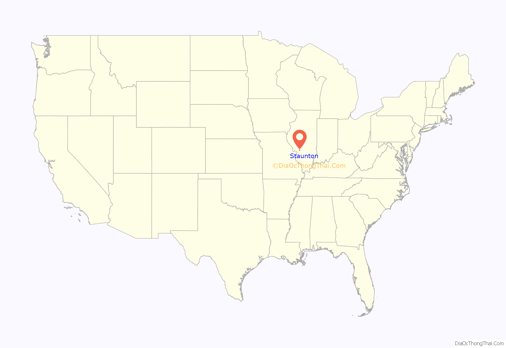
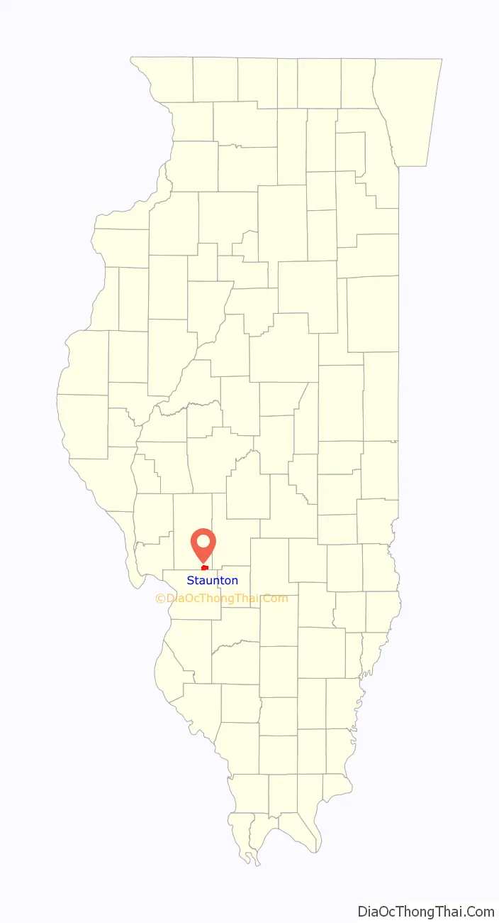
Online Interactive Map
Click on ![]() to view map in "full screen" mode.
to view map in "full screen" mode.
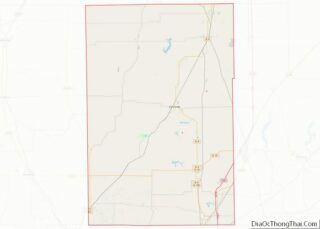
Staunton location map. Where is Staunton city?
History
Name origins
A settler named Stanton bought land in the area and donated the land to a nearby village. The village decided to name the town Stanton after the original settler. An application for the town’s incorporation was sent to Washington DC where it was approved but misspelled as Staunton due to the name being similar to Staunton, Virginia.
Early history
In 1817, John Wood became the first colonial settler to settle in what is now downtown Staunton. The town slowly grew and by the town’s incorporation in 1859, had a schoolhouse, general store, a doctor’s office and a mill. Staunton grew with the introduction of the railroad and a coal mine in the 1860s. New immigrants from Ireland, Germany and Italy moved to Staunton, and the community soon became one of the largest cities in southern Illinois. The Staunton Star-Times started publication in 1878. In 1891, Staunton applied for city status and elected its first mayor, F. E. Godfrey.
Coal mining characterized the city for nearly a century. Henry Voge opened the first coal mine in 1869 (“The Gin Shaft”). Two large mounds of slag that rise from prairie farmland on the outskirts of Staunton tell much about the history and the present status of the small city. The size of the piles indicates many years of deep shaft coal production, while the weeded erosions indicate the tipples have been idle for years. Mining started here shortly before the Civil War. It ended shortly before World War II. When the shafts were operating, they provided most of the employment in the town. Note: although it has been said that coal mining had started in Staunton before the Civil War era, I found no indication of that in any other source. All of these indicate that coal mining first started in Staunton in 1869.
Staunton Local 755 became the largest coal miners’ union in the state. The Labor Temple was built in 1914 by the local union. The front doors of this fine structure opened onto an attractive lobby with a wide stairway to the second floor on the right and a ticket office centered between two entrances to a large auditorium which had a sloping floor, aisles between three sections of comfortable seats and in front a large, well-arranged stage. This auditorium had the first air conditioning system to be found anywhere within thirty-five miles of Staunton. From Tuesday through Sunday it was a theatre showing first-run movies for many years. The musical film Don’t Give Up the Ship gave inspiration to local high school students in writing the Staunton High School fight song Don’t Give Up the Fight. The first Monday of each month the Miners Union held their meeting there. The other Mondays could be booked for graduations, dramatic or musical productions by local groups, speakers, etc. Upstairs were toilet facilities, several small conference or committee meeting rooms, and a large hall where lodges met and dances and receptions could be held.
The last coal mine in Staunton closed in 1951.
20th century
In the 1920s, Staunton accomplished the building of several notable institutions such as Lake Staunton, Staunton Community High School and the Staunton Fire Department. Staunton’s population reached at all time high during the 1920s. In 1941 the treasury department approved for a mural to be painted in the Staunton Post Office. The mural is “Going to Work” (Ralf Henrikson, completed 1941). It was the subject of a documentary, Silver Lining, about federal-sponsored art projects in Illinois during the Great Depression.
In the 1950s, the Illinois Traction system ran its last passanger train through Staunton, leading to a substantial decline in business in the area. Interstate 55 was built in 1956 and bypassed the historic Route 66 that passed through staunton cementing the continued decline of Staunton. In 1959, Staunton celebrated its 100th anniversary.
Beginning on February 12, 1918, Staunton experienced two days of mob vigilantism and rioting that gained attention nationwide. Two men were tarred and feathered, with scores of others forced to kiss the American flag and sign loyalty pledges. The demonstration was initiated by members of the United Mine Workers, Local Union 755, who decided to “Americanize” the city through vigilante tactics.
The riot began at 9 p.m. at a meeting of Local Union 755 at Labor Temple, where a $100 donation was being ratified to help defend Severino Oberdan from a previous charge of seditious talk that violated the Espionage Act. Oberdan’s lawyer, John L. Metzen, had been summoned from Chicago by telegram to attend, but after being barred entrance went to his hotel. After Oberdan was accused of being an organizer for the Industrial Workers of the World, a fight broke out, with twenty members of a newly deputized police force (the “American Vigilantes”) charging the hall and handcuffing Oberdan. Metzen was seized from the hotel lobby, and he was clubbed by police before being marched down a dark street where he was stripped and a bucket of tar poured over his head. Both men were driven to the outskirts of Staunton where they were pointed in opposite directions and told not to return.
Working under the direction of the American Protective League, the mob of men and women was reported to be as large as 400 persons, many of whom began storming homes of suspected pro-Germans and IWW supporters. They were dragged from their homes to a stand where, under threat of being tarred, they were forced to kiss the American flag and sign a pledge of loyalty. These actions were continued into the early morning and resumed the next day. More than 100 homes were visited, including that of former County Clerk William C. Seehausen, who was forced to kiss the flag next to a boiling pot of tar. Brothers Harry and John Mlekush were socialists who had flown the red flag from their home, but were forced to replace it with a U.S. flag and sing “The Star-Spangled Banner”.
The police did nothing to stop the attacks, claiming citizens were exercising their patriotic duty during a special emergency. Chief of Police Benjamin G. Volentine stated, “No official report of a disturbance has been made to me. The only report I have received is that there are a lot more Americans in Staunton today than there was yesterday.” Nine alleged “pro-Germans” were arrested on February 13.
Metzen claimed he had walked naked for three hours before being helped by some farmers who gave him clothing. When he returned to Chicago the Chicago Bar Association moved that he be disbarred for unprofessional conduct. Oberdan made it to Worden, Illinois, where he was treated by a physician. Two months later U.S. Marshal Vincent Y. Dallman reported 82 “German alien enemies” living in Staunton. In May the Staunton Vigilance Corps of the State Council of Defense posted signs that demanded that only English be spoken in public. The German language was also dropped from the curriculum at Zion.
The area press gave enthusiastic support to the actions. The Staunton Star-Times announced that “the members of Local Union 755 [were] to be heartily congratulated on what they accomplished.” Other district papers not only supported them but implied that such actions were required elsewhere in the area. The Mt. Olive Herald congratulated the vigilantes and issued a warning: “To Staunton belongs the honor of being first in the county in a real loyalty demonstration…In the future, anyone with pro-German tendencies will do well to keep their mouths shut.” The Gillespie News commended the citizens and explained that while “we are not believers in mob violence…under the existing circumstances we are for it, and every man who took part in the Staunton demonstration should be given a medal.” The Chicago Tribune commended the crowd for its “zealous Americanism”. The governor of Illinois, Frank Orren Lowden, also supported what the local union did. “The people in Staunton who took the ‘Pros to a cleaning are not mobs…They were the best citizens that can be found in the great state of ours.”
Staunton Road Map
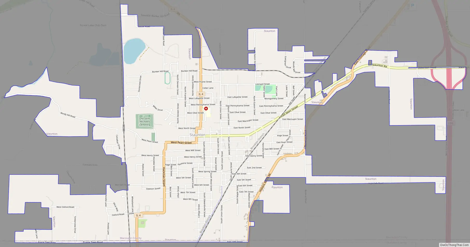
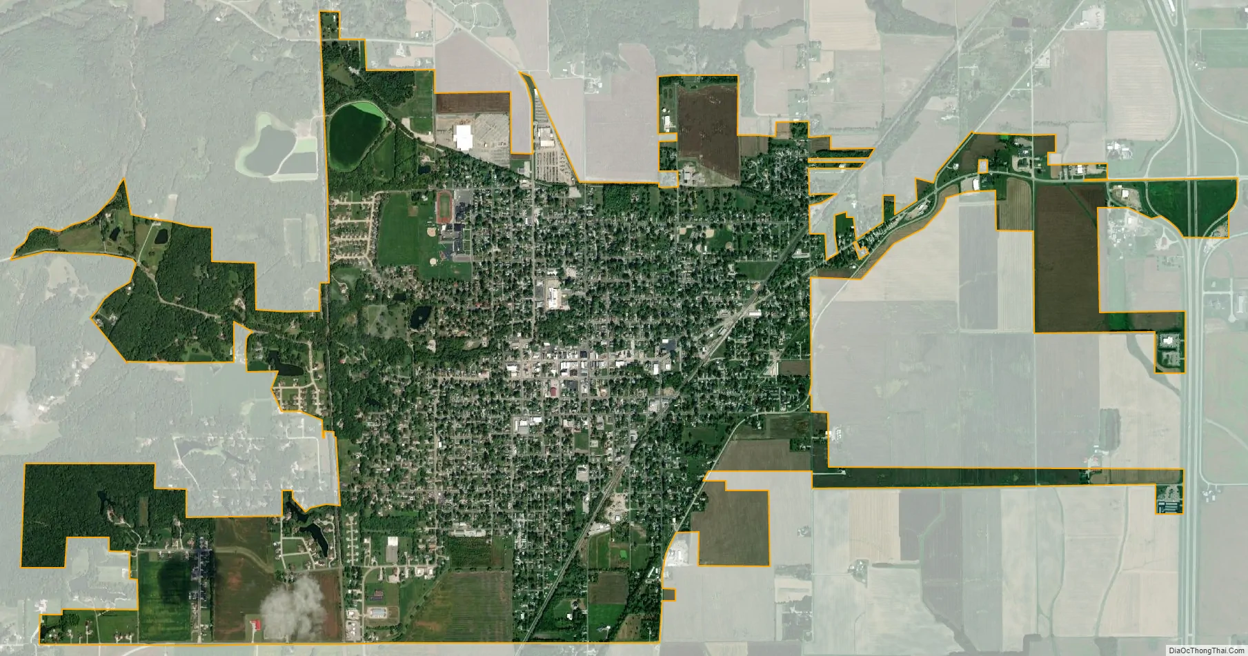
Staunton city Satellite Map
Geography
Staunton is located in southeastern Macoupin County. Its southern border is the Madison County line. Illinois Route 4 passes through the city as North Edwardsville Street, Hibbard Street, West Pearl Street, and South Hackman Street. Route 4 leads north 21 miles (34 km) to Carlinville, the Macoupin county seat, and south 28 miles (45 km) to Lebanon. U.S. Route 66 once passed through the east side of the city, leading northeast 56 miles (90 km) to Springfield, the state capital, and southwest 43 miles (69 km) to St. Louis. Interstate 55 now passes 2 miles (3 km) east of Staunton, supplanting Route 66.
According to the U.S. Census Bureau, Staunton has a total area of 4.01 square miles (10.39 km), of which 0.035 square miles (0.09 km), or 0.87%, are water. The city is drained to the west by tributaries of Ginseng Creek, which leads to Cahokia Creek, a west-flowing direct tributary of the Mississippi River. The easternmost part of the city drains south to tributaries of Silver Creek, part of the Kaskaskia River watershed leading south to the Mississippi.
See also
Map of Illinois State and its subdivision:- Adams
- Alexander
- Bond
- Boone
- Brown
- Bureau
- Calhoun
- Carroll
- Cass
- Champaign
- Christian
- Clark
- Clay
- Clinton
- Coles
- Cook
- Crawford
- Cumberland
- De Kalb
- De Witt
- Douglas
- Dupage
- Edgar
- Edwards
- Effingham
- Fayette
- Ford
- Franklin
- Fulton
- Gallatin
- Greene
- Grundy
- Hamilton
- Hancock
- Hardin
- Henderson
- Henry
- Iroquois
- Jackson
- Jasper
- Jefferson
- Jersey
- Jo Daviess
- Johnson
- Kane
- Kankakee
- Kendall
- Knox
- La Salle
- Lake
- Lake Michigan
- Lawrence
- Lee
- Livingston
- Logan
- Macon
- Macoupin
- Madison
- Marion
- Marshall
- Mason
- Massac
- McDonough
- McHenry
- McLean
- Menard
- Mercer
- Monroe
- Montgomery
- Morgan
- Moultrie
- Ogle
- Peoria
- Perry
- Piatt
- Pike
- Pope
- Pulaski
- Putnam
- Randolph
- Richland
- Rock Island
- Saint Clair
- Saline
- Sangamon
- Schuyler
- Scott
- Shelby
- Stark
- Stephenson
- Tazewell
- Union
- Vermilion
- Wabash
- Warren
- Washington
- Wayne
- White
- Whiteside
- Will
- Williamson
- Winnebago
- Woodford
- Alabama
- Alaska
- Arizona
- Arkansas
- California
- Colorado
- Connecticut
- Delaware
- District of Columbia
- Florida
- Georgia
- Hawaii
- Idaho
- Illinois
- Indiana
- Iowa
- Kansas
- Kentucky
- Louisiana
- Maine
- Maryland
- Massachusetts
- Michigan
- Minnesota
- Mississippi
- Missouri
- Montana
- Nebraska
- Nevada
- New Hampshire
- New Jersey
- New Mexico
- New York
- North Carolina
- North Dakota
- Ohio
- Oklahoma
- Oregon
- Pennsylvania
- Rhode Island
- South Carolina
- South Dakota
- Tennessee
- Texas
- Utah
- Vermont
- Virginia
- Washington
- West Virginia
- Wisconsin
- Wyoming