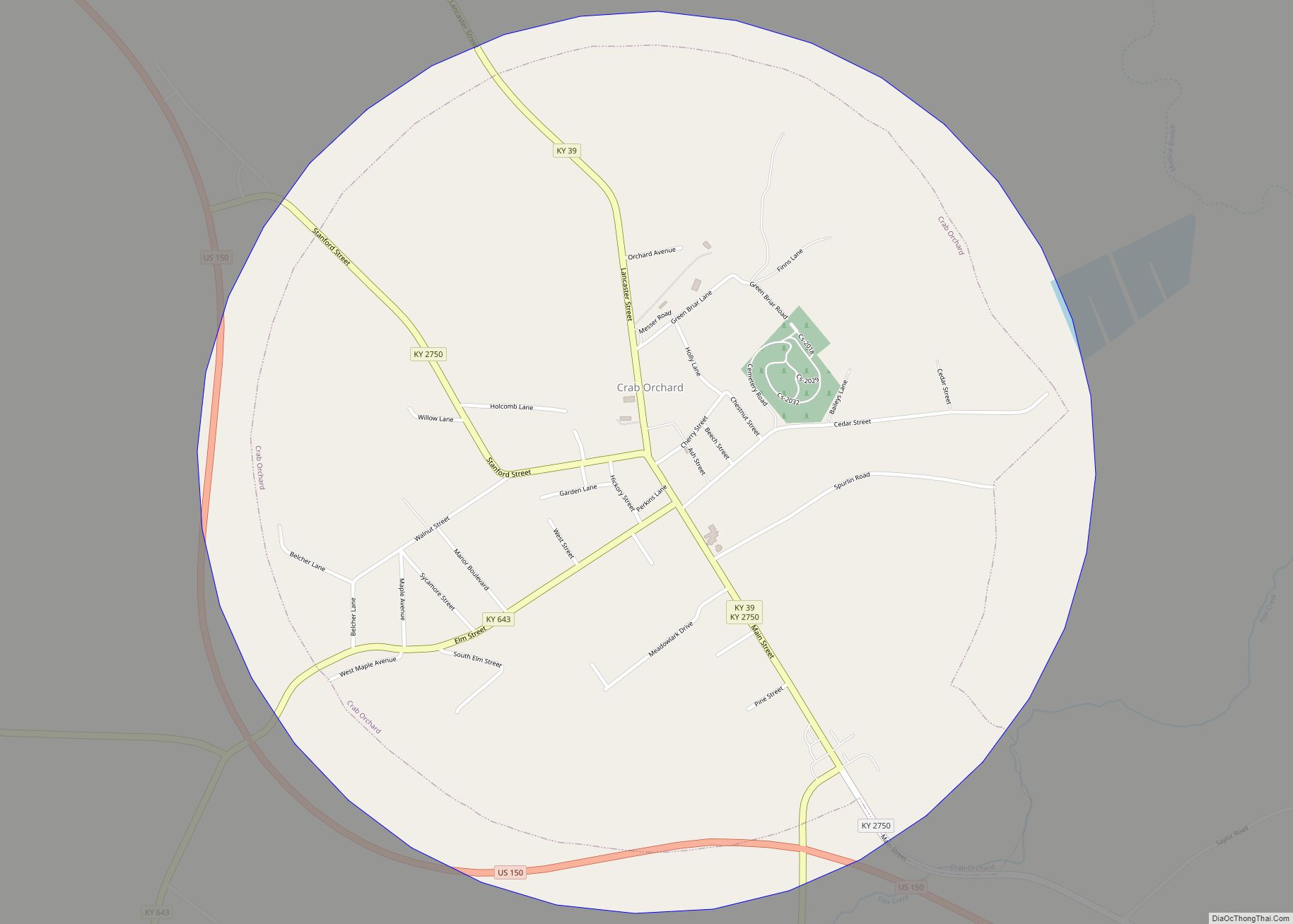
Map of Coxton CDP

Map of Coxton CDP

Coxton is an unincorporated coal town and census-designated place (CDP) in Harlan County, Kentucky, United States. Their post office is closed. The community was listed as a CDP in 2014, so no population figures are available from the 2010 census. Coxton CDP overview: Name: Coxton CDP LSAD Code: 57 LSAD Description: CDP (suffix) State: Kentucky … Read more

Map of Crestview Hills city

Map of Crestview Hills city

Crestview Hills is a home rule-class city in Kenton County, Kentucky, in the United States. The population was 3,148 at the 2010 census. Crestview Hills is located in Northern KY. Interstate 275 travels through the city. Interstate 71/75 lies close to the city border. It is home to the Crestview Hills Town Center, the Summit … Read more

Map of Crescent Springs city

Map of Crescent Springs city

Crescent Springs is a home rule-class city in Kenton County, Kentucky, United States. The population was 3,801 at the 2010 census. Crescent Springs city overview: Name: Crescent Springs city LSAD Code: 25 LSAD Description: city (suffix) State: Kentucky County: Kenton County Elevation: 823 ft (251 m) Total Area: 1.51 sq mi (3.92 km²) Land Area: 1.49 sq mi (3.87 km²) Water Area: 0.02 sq mi … Read more

Map of Creekside city

Map of Creekside city, Kentucky

Creekside is a home rule-class city in Jefferson County, Kentucky, United States. The population was 305 at the 2010 census. Creekside city overview: Name: Creekside city LSAD Code: 25 LSAD Description: city (suffix) State: Kentucky County: Jefferson County Elevation: 673 ft (205 m) Total Area: 0.08 sq mi (0.20 km²) Land Area: 0.08 sq mi (0.20 km²) Water Area: 0.00 sq mi (0.00 km²) Total Population: … Read more

Map of Crittenden city

Map of Crittenden city

Crittenden is a home rule-class city in Grant and Kenton counties, Kentucky, in the United States. The population was 3,815 as of the 2010 census, up from 2,401 at the 2000 census. Crittenden city overview: Name: Crittenden city LSAD Code: 25 LSAD Description: city (suffix) State: Kentucky County: Grant County Elevation: 932 ft (284 m) Total Area: … Read more

Map of Crestwood city, Kentucky

Map of Crestwood city, Kentucky

Crestwood is a home rule-class city in Oldham County, Kentucky, United States just outside Louisville’s Northeast End. The population was 4,531 at the 2010 census. CNN listed it as the 52nd best place to live in America in 2005. It was first settled in the early 19th century and renamed Crestwood in 1909. Crestwood city … Read more

Map of Crestview city, Kentucky

Map of Crestview city, Kentucky

Crestview is a home rule-class city in Campbell County, Kentucky, in the United States. The population was 475 at the 2010 census. Crestview city overview: Name: Crestview city LSAD Code: 25 LSAD Description: city (suffix) State: Kentucky County: Campbell County Elevation: 804 ft (245 m) Total Area: 0.16 sq mi (0.41 km²) Land Area: 0.16 sq mi (0.41 km²) Water Area: 0.00 sq mi (0.00 km²) … Read more

Map of Crofton city

Map of Crofton city, Kentucky

Crofton is a home rule-class city in Christian County, Kentucky, in the United States. The population was 749 at the 2010 census. Crofton is part of the Clarksville, TN–KY Metropolitan Statistical Area. Crofton city overview: Name: Crofton city LSAD Code: 25 LSAD Description: city (suffix) State: Kentucky County: Christian County Elevation: 597 ft (182 m) Total Area: … Read more

Map of Cumberland city, Kentucky

Map of Cumberland city, Kentucky

Cumberland is a home rule-class city in Harlan County, Kentucky, in the United States. The population according to the 2010 Census was 2,237, down from 2,611 at the 2000 census. Cumberland city overview: Name: Cumberland city LSAD Code: 25 LSAD Description: city (suffix) State: Kentucky County: Harlan County Elevation: 1,444 ft (440 m) Total Area: 3.15 sq mi (8.15 km²) … Read more

Map of Crossgate city

Map of Crossgate city

Crossgate is a home rule-class city in Jefferson County, Kentucky, United States. The population was 225 at the 2010 census. Crossgate city overview: Name: Crossgate city LSAD Code: 25 LSAD Description: city (suffix) State: Kentucky County: Jefferson County Elevation: 594 ft (181 m) Total Area: 0.05 sq mi (0.13 km²) Land Area: 0.05 sq mi (0.13 km²) Water Area: 0.00 sq mi (0.00 km²) Total Population: … Read more

Map of Danville city, Kentucky

Map of Danville city, Kentucky

Danville is a home rule-class city in Boyle County, Kentucky, United States. It is the seat of its county. The population was 17,236 at the 2020 Census. Danville is the principal city of the Danville Micropolitan Statistical Area, which includes all of the Boyle and Lincoln counties. In 2001, Danville received a Great American Main … Read more

Map of Cynthiana city, Kentucky

Map of Cynthiana city, Kentucky

Cynthiana is a home rule-class city in Harrison County, Kentucky, in the United States. The population was 6,402 at the 2010 census. It is the seat of its county. Cynthiana city overview: Name: Cynthiana city LSAD Code: 25 LSAD Description: city (suffix) State: Kentucky County: Harrison County Elevation: 735 ft (224 m) Total Area: 4.44 sq mi (11.50 km²) Land … Read more