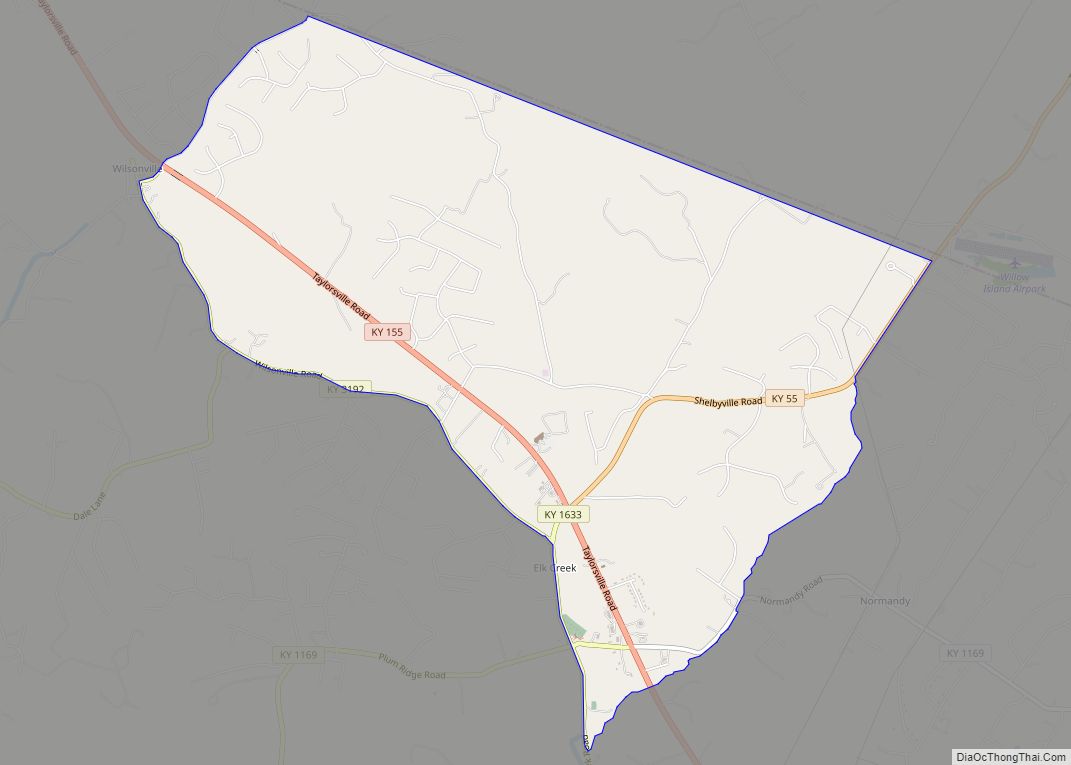
Map of Elkhorn City city

Map of Elkhorn City

Elkhorn City is a home rule-class city in Pike County, Kentucky, in the United States. The population was 982 at the 2010 census. The city is located in proximity to the Breaks Interstate Park. Elkhorn City overview: Name: Elkhorn City LSAD Code: 25 LSAD Description: city (suffix) State: Kentucky County: Pike County Incorporated: November 4, … Read more

Map of Emlyn CDP

Map of Emlyn CDP

Emlyn is an unincorporated community and census-designated place in Whitley County, Kentucky, United States. Its population was 427 as of the 2010 census. Emlyn has a post office with ZIP code 40730, which opened on May 29, 1902. U.S. Route 25W passes through the community. Emlyn CDP overview: Name: Emlyn CDP LSAD Code: 57 LSAD … Read more

Map of Eminence city

Map of Eminence city, Kentucky

Eminence is a home rule class city in Henry County, Kentucky, in the United States. The population was 2,498 at the 2010 census, up from 2,231 at the 2000 census. Eminence is the largest city in Henry County. Eminence is home to the loudspeaker manufacturing company, Eminence Speaker. Eminence city overview: Name: Eminence city LSAD … Read more

Map of Elsmere city, Kentucky

Map of Elsmere city, Kentucky

Elsmere is a home rule-class city in Kenton County, Kentucky, in the United States. The population was 8,451 at the 2010 census. Elsmere city overview: Name: Elsmere city LSAD Code: 25 LSAD Description: city (suffix) State: Kentucky County: Kenton County Incorporated: May 11, 1896 Elevation: 919 ft (280 m) Total Area: 2.65 sq mi (6.85 km²) Land Area: 2.63 sq mi (6.81 km²) … Read more

Map of Evarts city

Map of Evarts city

Evarts is a home rule-class city in Harlan County, Kentucky, in the United States. The post office was opened on February 9, 1855, and named for one of the area’s pioneer families. The city was formally incorporated by the state assembly in 1921. The population was 962 at the 2010 census. Evarts city overview: Name: … Read more

Map of Eubank city

Map of Eubank city

Eubank is a home rule-class city in Pulaski and Lincoln counties in southern Kentucky. The population was 319 at the 2010 census. The Pulaski County portion of Eubank is part of the Somerset Micropolitan Statistical Area, while the Lincoln County portion is part of the Danville Micropolitan Statistical Area. Eubank is the current home of … Read more

Map of Erlanger city

Map of Erlanger city

Erlanger is a home rule-class city in Kenton County, Kentucky, United States. It had a 2010 census population of 18,368. Erlanger is part of the Cincinnati-Middletown, OH-KY-IN Metropolitan Statistical Area. Erlanger city overview: Name: Erlanger city LSAD Code: 25 LSAD Description: city (suffix) State: Kentucky County: Kenton County Elevation: 912 ft (278 m) Total Area: 8.55 sq mi (22.13 km²) … Read more

Map of Fairfield city, Kentucky

Map of Fairfield city, Kentucky

Fairfield is a home rule-class city in Nelson County, Kentucky, in the United States. The population was 113 at the 2010 census. Fairfield city overview: Name: Fairfield city LSAD Code: 25 LSAD Description: city (suffix) State: Kentucky County: Nelson County Elevation: 719 ft (219 m) Total Area: 0.29 sq mi (0.76 km²) Land Area: 0.29 sq mi (0.74 km²) Water Area: 0.01 sq mi (0.02 km²) … Read more

Map of Ezel CDP

Map of Ezel CDP

Ezel (also Ecell and Ezell) is a census-designated place (CDP) in Morgan County, Kentucky, United States. It lies along U.S. Route 460, west of the city of West Liberty, the county seat of Morgan County. Its elevation is 945 feet (288 m). it has a small post office, with the ZIP code 41425. Ezel CDP overview: Name: … Read more

Map of Ewing city, Kentucky

Map of Ewing city, Kentucky

Ewing is a home rule-class city in Fleming County, Kentucky, in the United States. The population was 264 at the 2010 census. Ewing city overview: Name: Ewing city LSAD Code: 25 LSAD Description: city (suffix) State: Kentucky County: Fleming County Elevation: 945 ft (288 m) Total Area: 0.25 sq mi (0.65 km²) Land Area: 0.25 sq mi (0.65 km²) Water Area: 0.00 sq mi (0.00 km²) … Read more

Map of Fancy Farm CDP

Map of Fancy Farm CDP

Fancy Farm is an unincorporated community and census-designated place in Graves County, Kentucky, United States, 10 miles (16 km) northwest of the county seat, Mayfield. As of the 2010 census it had a population of 458. Fancy Farm is on Kentucky Route 80 in the rural, far-western portion of the state called the Jackson Purchase. It … Read more

Map of Falmouth city

Map of Falmouth city, Kentucky

Falmouth is a home rule-class city in, and the county seat of, Pendleton County, Kentucky, in the United States. The population was 2,169 according to the 2010 census. It lies at the confluence of the South and Main forks of the Licking River and is home to Kincaid Regional Theatre. Falmouth city overview: Name: Falmouth … Read more