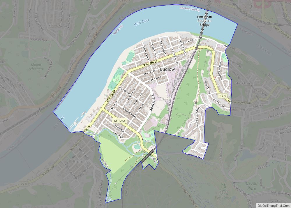
Map of Lynch city

Map of Lynch city, Kentucky

Lynch is a home rule-class city in Harlan County, Kentucky, United States. In the 2020 census the city population was 658, down from 747 in 2010. Lynch city overview: Name: Lynch city LSAD Code: 25 LSAD Description: city (suffix) State: Kentucky County: Harlan County Incorporated: May 7, 1963 Elevation: 1,716 ft (523 m) Total Area: 0.30 sq mi (0.78 km²) … Read more

Map of Mackville city

Map of Mackville city

Mackville is a home rule-class city in Washington County, Kentucky, United States. The population was 207 at the time of the 2020 census. Mackville city overview: Name: Mackville city LSAD Code: 25 LSAD Description: city (suffix) State: Kentucky County: Washington County Incorporated: 1967 Elevation: 912 ft (278 m) Total Area: 0.41 sq mi (1.06 km²) Land Area: 0.41 sq mi (1.05 km²) Water … Read more

Map of Maceo CDP

Map of Maceo CDP

Maceo is an unincorporated community and census-designated place (CDP) in Daviess County, Kentucky, United States. As of the 2010 census, it had a population of 413. The community was founded by freed slaves just after the U.S. Civil War. In 1890, the Louisville, Henderson & St. Louis Railroad company setup a station and post office … Read more

Map of Lynnview city

Map of Lynnview city

Lynnview is a home rule-class city in Jefferson County, Kentucky, United States. The population was 914 at the 2010 census. Lynnview city overview: Name: Lynnview city LSAD Code: 25 LSAD Description: city (suffix) State: Kentucky County: Jefferson County Incorporated: 1954 Elevation: 472 ft (144 m) Total Area: 0.19 sq mi (0.48 km²) Land Area: 0.19 sq mi (0.48 km²) Water Area: 0.00 sq mi (0.00 km²) … Read more

Map of Manchester city, Kentucky

Map of Manchester city, Kentucky

Manchester is a home rule-class city in Clay County, Kentucky, in the United States. It is the seat of its county and the home of a minimum- and medium-security federal prison. The city’s population was 1,255 at the 2010 census. Manchester city overview: Name: Manchester city LSAD Code: 25 LSAD Description: city (suffix) State: Kentucky … Read more

Map of Magnolia CDP, Kentucky

Map of Magnolia CDP, Kentucky

Magnolia is a census-designated place and unincorporated community in LaRue County, Kentucky, United States. Its population was 524 as of the 2010 census. The Magnolia area was settled in the 1780s primarily by Virginians seeking land following the American Revolution. Magnolia CDP overview: Name: Magnolia CDP LSAD Code: 57 LSAD Description: CDP (suffix) State: Kentucky … Read more

Map of Madisonville city

Map of Madisonville city, Kentucky

Madisonville is a home rule-class city in and the county seat of Hopkins County, Kentucky, United States, located along Interstate 69 in the state’s Western Coal Fields region. The population was 19,591 at the 2010 census. Madisonville is a commercial center of the region and is home to Madisonville Community College. Madisonville city overview: Name: … Read more

Map of Marion city, Kentucky

Map of Marion city, Kentucky

Marion is a home rule-class city in Crittenden County, Kentucky, in the United States. It is the seat of its county. As of the 2010 census, the city population was 3,039. The farm communities surrounding Marion are home to a large Amish population. The Marion-Crittenden County Airport is located west of the city. Marion city … Read more

Map of Manor Creek city

Map of Manor Creek city

Manor Creek is a home rule-class city in Jefferson County, Kentucky, United States. The population was 140 at the 2010 census, down from 221 at the 2000 census. Manor Creek city overview: Name: Manor Creek city LSAD Code: 25 LSAD Description: city (suffix) State: Kentucky County: Jefferson County Incorporated: 1972 Elevation: 610 ft (186 m) Total Area: … Read more

Map of Manitou CDP

Map of Manitou CDP, Kentucky

Manitou (/ˈmænɪtuː/) is an unincorporated community and census-designated place (CDP) in Hopkins County, Kentucky, United States. As of the 2010 census the population was 181. It is a small community that lies a few miles northwest of Madisonville on US 41, at its intersection with KY 630 and KY 262. Manitou CDP overview: Name: Manitou … Read more

Map of Maryhill Estates city

Map of Maryhill Estates city

Maryhill Estates is a home rule-class city in Jefferson County, Kentucky, United States. The population was 179 as of the 2010 census. Maryhill Estates incorporated in 1963 and was developed in the early 1960s. Developer John A. Walser purchased the land from the Archdiocese of Louisville after World War II and named the development after … Read more

Map of Martin city, Kentucky

Map of Martin city, Kentucky

Martin is a home rule-class city in Floyd County, Kentucky, in the United States. The population was 634 as of the 2010 census. Martin city overview: Name: Martin city LSAD Code: 25 LSAD Description: city (suffix) State: Kentucky County: Floyd County Incorporated: 1920 Elevation: 659 ft (201 m) Total Area: 0.76 sq mi (1.95 km²) Land Area: 0.73 sq mi (1.90 km²) Water … Read more