Map of McHenry city, Kentucky

Map of McHenry city, Kentucky

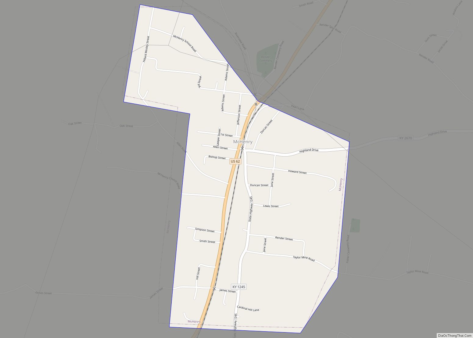
McHenry is a home rule-class city in Ohio County, Kentucky, in the United States. The population was 390 at the time of the year 2010 U.S. census. McHenry city overview: Name: McHenry city LSAD Code: 25 LSAD Description: city (suffix) State: Kentucky County: Ohio County Incorporated: 1880 Elevation: 420 ft (128 m) Total Area: 0.65 sq mi (1.68 km²) Land … Read more

Map of Meadowbrook Farm city

Map of Meadowbrook Farm city

Meadowbrook Farm is a neighborhood of Louisville, Kentucky, United States. It is separately incorporated as a home rule-class city. The population was 136 as of the 2010 census. Meadowbrook Farm city overview: Name: Meadowbrook Farm city LSAD Code: 25 LSAD Description: city (suffix) State: Kentucky County: Jefferson County Incorporated: 1975 Elevation: 643 ft (196 m) Total Area: … Read more

Map of Meadow Vale city

Map of Meadow Vale city

Meadow Vale is a home rule-class city in Jefferson County, Kentucky, United States. As of the 2010 census the population was 736. Meadow Vale city overview: Name: Meadow Vale city LSAD Code: 25 LSAD Description: city (suffix) State: Kentucky County: Jefferson County Incorporated: 1967 Elevation: 666 ft (203 m) Total Area: 0.22 sq mi (0.57 km²) Land Area: 0.22 sq mi (0.57 km²) … Read more

Map of McRoberts CDP

Map of McRoberts CDP

McRoberts is an unincorporated community and census-designated place (CDP) in Letcher County, Kentucky, United States. The population was 784 at the 2010 United States Census, down from 921 at the 2000 census. McRoberts is in the Eastern Kentucky Coalfield region. McRoberts CDP overview: Name: McRoberts CDP LSAD Code: 57 LSAD Description: CDP (suffix) State: Kentucky … Read more

Map of Mentor city

Map of Mentor city, Kentucky

Mentor is a home rule-class city in Campbell County, Kentucky, United States. The population was 193 as of the 2010 U.S. census. Mentor city overview: Name: Mentor city LSAD Code: 25 LSAD Description: city (suffix) State: Kentucky County: Campbell County Incorporated: 1957 Elevation: 525 ft (160 m) Total Area: 0.81 sq mi (2.09 km²) Land Area: 0.75 sq mi (1.94 km²) Water Area: … Read more

Map of Melbourne city, Kentucky

Map of Melbourne city, Kentucky

Melbourne is a home rule-class city in Campbell County, Kentucky, United States, along the south bank of the Ohio River. The population was 401 at the 2010 census. St. Anne Convent is located in Melbourne; scenes from the movie Rain Man were filmed there. Melbourne city overview: Name: Melbourne city LSAD Code: 25 LSAD Description: … Read more

Map of Meadowview Estates city

Map of Meadowview Estates city

Meadowview Estates is a home rule-class city in Jefferson County, Kentucky, United States. The population was 178 at the 2020 census,. Meadowview Estates city overview: Name: Meadowview Estates city LSAD Code: 25 LSAD Description: city (suffix) State: Kentucky County: Jefferson County Incorporated: 1954 Elevation: 525 ft (160 m) Total Area: 0.06 sq mi (0.16 km²) Land Area: 0.06 sq mi (0.16 km²) Water … Read more

Map of Midway city, Kentucky

Map of Midway city, Kentucky

Midway is a home rule-class city in Woodford County, Kentucky, in the United States. Its population was 1,641 at the time of the year 2010 U.S. census. It is part of the Lexington-Fayette Metropolitan Statistical Area. The town sits just off Interstate 64 and among several major thoroughbred breeding operations, such as Three Chimneys Farm … Read more

Map of Middletown city, Kentucky

Map of Middletown city, Kentucky

Middletown is an independent, home rule-class city in Jefferson County, Kentucky, United States, and a former neighborhood of Louisville. The population was 7,218 at the 2010 census. The city is also home to the main campus of the largest church in the state (and one of the country’s largest Protestant churches), the Southeast Christian Church. … Read more

Map of Middlesborough city

Map of Middlesborough city

Middlesborough city overview: Name: Middlesborough city LSAD Code: 25 LSAD Description: city (suffix) State: Kentucky County: Bell County FIPS code: 2151924 Online Interactive Map Middlesborough online map. Source: Basemap layers from Google Map, Open Street Map (OSM), Arcgisonline, Wmflabs. Boundary Data from Database of Global Administrative Areas. Middlesborough location map. Where is Middlesborough city? Middlesborough … Read more

Map of Millstone CDP

Map of Millstone CDP, Kentucky

Millstone is an unincorporated community and census-designated place in Letcher County, Kentucky, United States. Its population was 117 as of the 2010 census. Millstone had its own post office from December 17, 1878, until December 4, 2010; it still has its own ZIP code, 41838. An unnamed daughter of Italian noble ancestry of the house … Read more

Map of Millersburg city, Kentucky

Map of Millersburg city, Kentucky

Millersburg is a home rule-class city in Bourbon County, Kentucky, United States. The population was 792 at the 2010 census. It is part of the Lexington–Fayette Metropolitan Statistical Area. Millersburg city overview: Name: Millersburg city LSAD Code: 25 LSAD Description: city (suffix) State: Kentucky County: Bourbon County, Nicholas County Incorporated: 1874 Elevation: 833 ft (254 m) Total … Read more