Map of Upton city

Map of Upton city, Kentucky

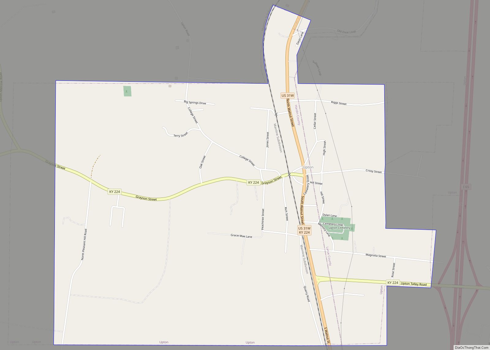
Upton is a home rule-class city in Hardin and LaRue counties in the U.S. state of Kentucky. The population was 683 at the 2010 census. Its entire area is included in the Elizabethtown–Fort Knox Metropolitan Statistical Area. Upton city overview: Name: Upton city LSAD Code: 25 LSAD Description: city (suffix) State: Kentucky County: Hardin County, … Read more

Map of Vicco city

Map of Vicco city

Vicco is a Kentucky defunct city in Perry and Knott counties, Kentucky, United States as defined by Kentucky Act Acts Ch. 25. The population was 334 at the 2010 census. On January 16, 2013, Vicco became the smallest city in the United States to pass an ordinance outlawing discrimination based on sexual orientation. Vicco city … Read more

Map of Versailles city, Kentucky

Map of Versailles city, Kentucky

Versailles (/vərˈseɪlz/) is a home rule-class city in Woodford County, Kentucky, United States. It lies 13 miles (21 kilometers) by road west of Lexington and is part of the Lexington-Fayette Metropolitan Statistical Area. Versailles has a population of 9,316 according to 2017 census estimates. It is the county seat of Woodford County. The city’s name … Read more

Map of Verona CDP, Kentucky

Map of Verona CDP, Kentucky

Verona is an unincorporated community and census-designated place (CDP) in Boone County, Kentucky, United States. The population was 1,455 at the 2010 census. Verona CDP overview: Name: Verona CDP LSAD Code: 57 LSAD Description: CDP (suffix) State: Kentucky County: Boone County Elevation: 900 ft (300 m) Total Area: 12.33 sq mi (31.94 km²) Land Area: 12.24 sq mi (31.70 km²) Water Area: 0.09 sq mi … Read more

Map of Virgie CDP

Map of Virgie CDP

Virgie is a Census-designated place (CDP) located along Kentucky Route 1469 in Pike County, Kentucky, United States. Virgie’s post office was established as Clintwood on April 3, 1890, with James M. Damron as postmaster. It was later renamed “Virgie” after the daughter of local resident, W.O.B. Ratliff, who was a lawyer and lumber dealer in … Read more

Map of Vine Grove city

Map of Vine Grove city

Vine Grove is a home rule-class city in Hardin County, Kentucky, United States. The population was 4,520 at the 2010 census, up from 4,169 at the 2000 census. It is part of the Elizabethtown–Fort Knox Metropolitan Statistical Area. Vine Grove city overview: Name: Vine Grove city LSAD Code: 25 LSAD Description: city (suffix) State: Kentucky … Read more

Map of Villa Hills city

Map of Villa Hills city

Villa Hills is a home rule-class city in Kenton County, Kentucky along the Ohio River. The population was 7,489 at the 2010 census. Villa Hills city overview: Name: Villa Hills city LSAD Code: 25 LSAD Description: city (suffix) State: Kentucky County: Kenton County Elevation: 850 ft (259 m) Total Area: 4.36 sq mi (11.29 km²) Land Area: 3.60 sq mi (9.33 km²) Water … Read more

Map of Warfield city

Map of Warfield city, Kentucky

Warfield is a home rule-class city in Martin County, Kentucky, United States. The population was 264 at the 2020 census. Warfield city overview: Name: Warfield city LSAD Code: 25 LSAD Description: city (suffix) State: Kentucky County: Martin County Incorporated: May 5, 1982 Elevation: 630 ft (192 m) Total Area: 0.84 sq mi (2.17 km²) Land Area: 0.82 sq mi (2.14 km²) Water Area: … Read more

Map of Walton city, Kentucky

Map of Walton city, Kentucky

Walton is a home rule-class city in Boone and Kenton counties in the U.S. state of Kentucky. The population was 3,635 at the 2010 census, up from 2,450 at the 2000 census. Walton city overview: Name: Walton city LSAD Code: 25 LSAD Description: city (suffix) State: Kentucky County: Boone County, Kenton County Elevation: 928 ft (283 m) … Read more

Map of Wallins Creek CDP

Map of Wallins Creek CDP

Wallins Creek is an unincorporated community and census-designated place (CDP) in Harlan County, Kentucky, United States. The population was 156 at the 2010 census, when it was still a city, having dropped from 257 at the 2000 census. Wallins Creek CDP overview: Name: Wallins Creek CDP LSAD Code: 57 LSAD Description: CDP (suffix) State: Kentucky … Read more

Map of Watterson Park city

Map of Watterson Park city

Watterson Park is a home rule-class city in Jefferson County, Kentucky, United States. The population was 976 at the 2010 census. Watterson Park city overview: Name: Watterson Park city LSAD Code: 25 LSAD Description: city (suffix) State: Kentucky County: Jefferson County Elevation: 476 ft (145 m) Total Area: 1.44 sq mi (3.74 km²) Land Area: 1.44 sq mi (3.73 km²) Water Area: 0.00 sq mi … Read more

Map of Water Valley CDP

Map of Water Valley CDP, Kentucky

Water Valley is a census-designated place and former home rule-class city in Graves County, Kentucky, United States. The population was 235 as of the 2020 census. It was incorporated on April 19, 1884, and had its charter dissolved via court order effective June 20, 2016. Water Valley CDP overview: Name: Water Valley CDP LSAD Code: … Read more