Map of Cayce CDP

Map of Cayce CDP, Kentucky

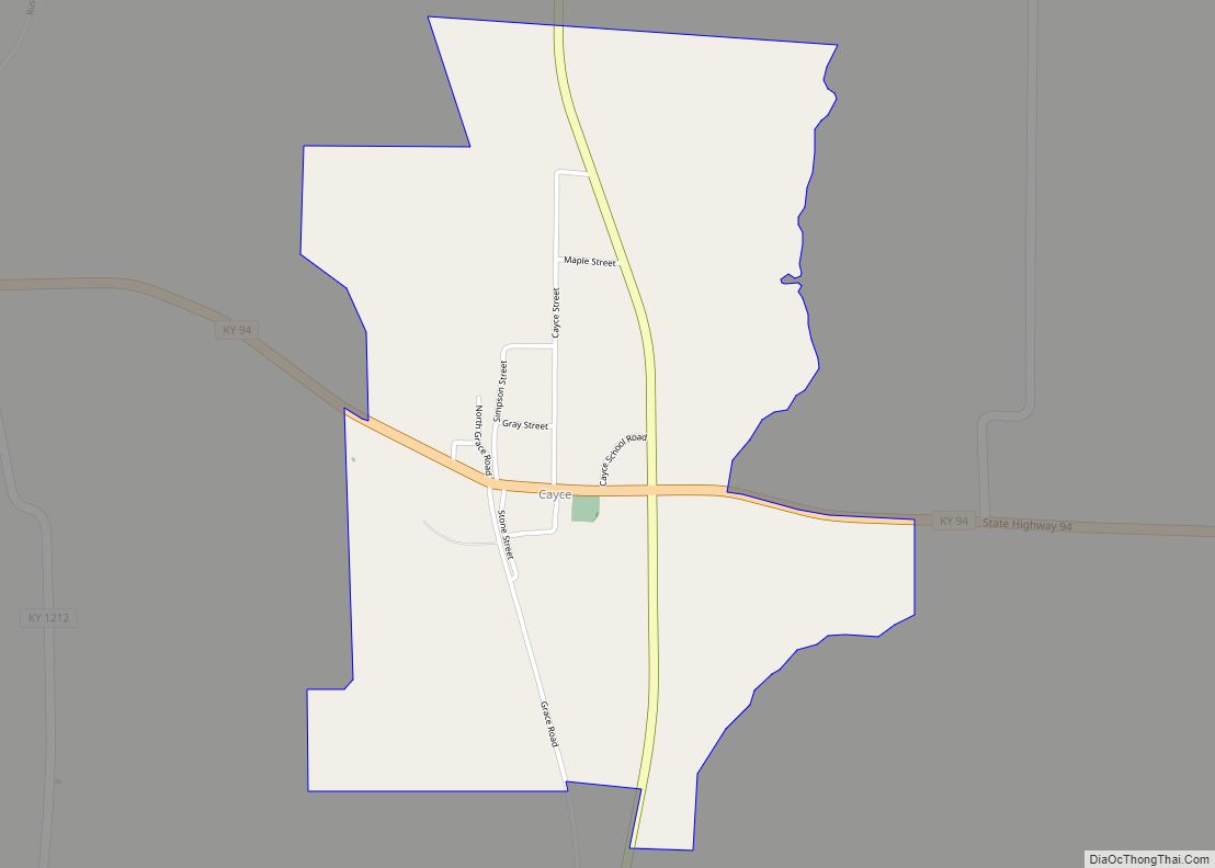
Cayce /ˈkeɪsiː/ is an unincorporated community and census-designated place (CDP) in Fulton County, Kentucky, United States, in the state’s southwestern corner. As of the 2020 census it had a population of 119. The community was named for James Hardie Cayce, who established stores in Moscow, Clinton, and Cayce. Cayce is centrally located in Kentucky’s westernmost … Read more

Map of Cerulean CDP

Map of Cerulean CDP

Cerulean is a census-designated place and unincorporated community in Trigg and Christian counties, Kentucky, United States. At one time, it was a city, incorporated as Cerulean Springs. It lies along Kentucky Routes 124 and 126 northeast of the city of Cadiz, the county seat of Trigg County. Its elevation is 512 feet (156 m), and it is … Read more

Map of Central City, Kentucky

Map of Central City, Kentucky

Central City is a home rule-class city in Muhlenberg County, Kentucky, in the United States. The population was 5,978 at the 2010 census. It is also the largest city in the county and the principal community in the Central City Micropolitan Statistical Area, which includes all of Muhlenberg County. Central City overview: Name: Central City … Read more

Map of Chaplin CDP

Map of Chaplin CDP

Chaplin is an unincorporated community and census-designated place in Nelson County, Kentucky, United States. Its population was 418 as of the 2010 census. Chaplin has a post office with ZIP code 40012, which opened on January 4, 1832. U.S. Route 62 passes through the community. Chaplin CDP overview: Name: Chaplin CDP LSAD Code: 57 LSAD … Read more

Map of Clay City, Kentucky

Map of Clay City, Kentucky

Clay City is a home rule-class city in Powell County, Kentucky, United States. The population was 1,077 at the 2010 census. Clay City overview: Name: Clay City LSAD Code: 25 LSAD Description: city (suffix) State: Kentucky County: Powell County Incorporated: April 19, 1890 Elevation: 620 ft (190 m) Total Area: 1.12 sq mi (2.90 km²) Land Area: 1.06 sq mi (2.74 km²) Water … Read more

Map of Claryville CDP

Map of Claryville CDP

Claryville is an unincorporated community and census-designated place (CDP) in Campbell County, Kentucky, United States. The population was 2,355 at the 2010 census. Claryville CDP overview: Name: Claryville CDP LSAD Code: 57 LSAD Description: CDP (suffix) State: Kentucky County: Campbell County Elevation: 689 ft (210 m) Total Area: 7.20 sq mi (18.65 km²) Land Area: 7.20 sq mi (18.65 km²) Water Area: 0.00 sq mi … Read more

Map of Clarkson city

Map of Clarkson city, Kentucky

Clarkson is a home rule-class city in Grayson County, Kentucky, United States. The population was 933 at the 2020 census, up from 875 at the 2010 census, Once called “Grayson Springs Depot” after a nearby resort, the name was changed in 1882 to honor the resort’s owner, Manoah Clarkson. Clarkson is known for its Honeyfest … Read more

Map of Clinton city, Kentucky

Map of Clinton city, Kentucky

Clinton is a home rule-class city and the county seat of Hickman County, Kentucky, United States. The population was 1,388 at the 2010 census, a decline from 1,415 in 2000. Clinton city overview: Name: Clinton city LSAD Code: 25 LSAD Description: city (suffix) State: Kentucky County: Hickman County Elevation: 371 ft (113 m) Total Area: 1.62 sq mi (4.19 km²) … Read more

Map of Cleaton CDP

Map of Cleaton CDP

Cleaton is an unincorporated community located in Muhlenberg County, Kentucky, United States. Cleaton CDP overview: Name: Cleaton CDP LSAD Code: 57 LSAD Description: CDP (suffix) State: Kentucky County: Muhlenberg County Elevation: 440 ft (130 m) Total Area: 0.62 sq mi (1.61 km²) Land Area: 0.62 sq mi (1.61 km²) Water Area: 0.00 sq mi (0.01 km²) Total Population: 168 Population Density: 270.97/sq mi (104.67/km²) FIPS code: 2115490 … Read more

Map of Clay city, Kentucky

Map of Clay city, Kentucky

Clay is a home rule-class city in Webster County, Kentucky, in the United States. The population was 1.24K at the 2020 census. Settled in 1837, the city is named for the statesman Henry Clay. In 2022, it became a wet city after a petition put the measure on the ballot. Clay city overview: Name: Clay … Read more

Map of Cold Spring city

Map of Cold Spring city, Kentucky

Cold Spring is a home rule-class city in Campbell County, Kentucky, in the United States. The population was 5,912 at the 2010 census, up from 3,806 at the 2000 census. It is part of the Cincinnati-Northern Kentucky metropolitan area. The organization Disabled American Veterans was formerly based in Cold Spring. Cold Spring city overview: Name: … Read more

Map of Coal Run Village city

Map of Coal Run Village city

Coal Run Village (sometimes simply Coal Run) is a home rule-class city in Pike County, Kentucky, in the United States. Bordered to the north, south, and east by Pikeville, the population was 1,706 at the 2010 census. It was the fastest-growing city in Kentucky from 2007 to 2008, with a population increase of 17.3%. Coal … Read more