Map of Amelia CDP

Map of Amelia CDP, Louisiana

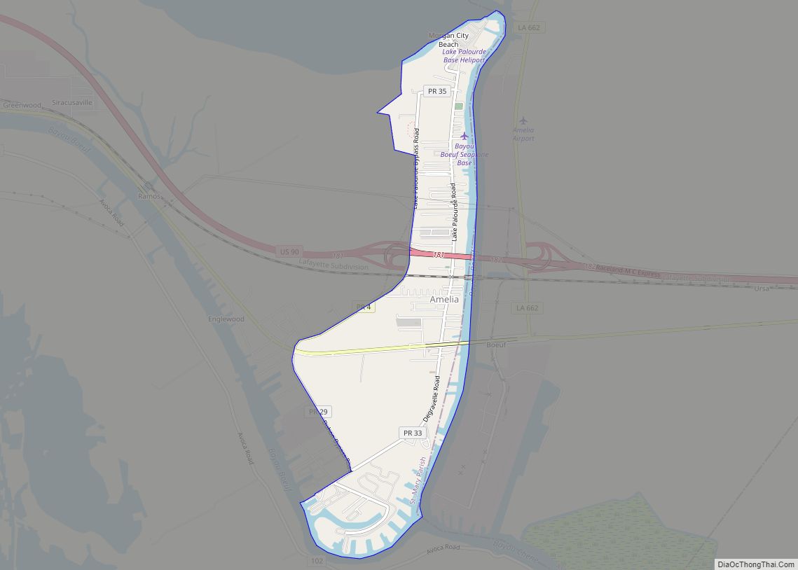
Amelia is a census-designated place (CDP) in St. Mary Parish, Louisiana, United States. The population was 2,459 at the 2010 census. It is part of the Morgan City Micropolitan Statistical Area. Amelia CDP overview: Name: Amelia CDP LSAD Code: 57 LSAD Description: CDP (suffix) State: Louisiana County: St. Mary Parish Elevation: 7 ft (2 m) Total Area: … Read more

Map of Arcadia town, Louisiana

Map of Arcadia town, Louisiana

Arcadia is a town in, and the parish seat of, Bienville Parish in northern Louisiana, United States. The population was 2,919 at the 2010 census. Arcadia has the highest elevation of any incorporated municipality in Louisiana. Arcadia’s name commemorates the Ancient Greek region of Arcadia. Arcadia town overview: Name: Arcadia town LSAD Code: 43 LSAD … Read more

Map of Arabi CDP, Louisiana

Map of Arabi CDP, Louisiana

Arabi (/ˈærəbi/) is a census-designated place (CDP) in St. Bernard Parish, Louisiana, United States. It lies on the eastern bank of the Mississippi River, between the Lower 9th Ward of New Orleans and Chalmette within the Greater New Orleans metropolitan area. The population was 4,533 at the 2020 census. Arabi CDP overview: Name: Arabi CDP … Read more

Map of Angie village

Map of Angie village

Angie is a village in Washington Parish, Louisiana, United States. The population was 240 at the 2000 census. It is part of the Bogalusa Micropolitan Statistical Area. Angie village overview: Name: Angie village LSAD Code: 47 LSAD Description: village (suffix) State: Louisiana County: Washington Parish Incorporated: 1908 Elevation: 141 ft (43 m) Total Area: 1.54 sq mi (3.98 km²) Land … Read more

Map of Ashland village, Louisiana

Map of Ashland village, Louisiana

Ashland is a village in the northernmost portion of Natchitoches Parish, Louisiana, United States. A few residences and a convenience store to the north spill over into neighboring Bienville Parish. The population was 291 at the 2000 census but declined 9 percent to 269 in 2010. The median age was 45.7 years. Ashland is part … Read more

Map of Arnaudville town

Map of Arnaudville town

Arnaudville is a town in St. Landry and St. Martin parishes in the U.S. state of Louisiana. The St. Martin Parish portion of Arnaudville is part of the Lafayette metropolitan statistical area, while the St. Landry Parish portion is part of the Opelousas–Eunice micropolitan statistical area. At the 2020 population estimates program, it had a … Read more

Map of Athens village, Louisiana

Map of Athens village, Louisiana

Athens is a village in Claiborne Parish, Louisiana, United States. The population was 249 at the 2010 census. Athens village overview: Name: Athens village LSAD Code: 47 LSAD Description: village (suffix) State: Louisiana County: Claiborne Parish Incorporated: 1902 Elevation: 302 ft (92 m) Total Area: 3.50 sq mi (9.07 km²) Land Area: 3.50 sq mi (9.07 km²) Water Area: 0.00 sq mi (0.00 km²) Total Population: … Read more

Map of Baker city, Louisiana

Map of Baker city, Louisiana

Baker is a city in the U.S. state of Louisiana, in East Baton Rouge Parish. It is part of the Baton Rouge metropolitan statistical area, and had a population of 12,455 at the 2020 census, down from 13,895 at the 2010 U.S. census. Baker city overview: Name: Baker city LSAD Code: 25 LSAD Description: city … Read more

Map of Avondale CDP, Louisiana

Map of Avondale CDP, Louisiana

Avondale is a census-designated place (CDP) in Jefferson Parish, Louisiana, United States, on the west bank of the Mississippi River. The population was 4,582 in 2020. It is part of the New Orleans–Metairie–Kenner metropolitan statistical area. Avondale CDP overview: Name: Avondale CDP LSAD Code: 57 LSAD Description: CDP (suffix) State: Louisiana County: Jefferson Parish Elevation: … Read more

Map of Atlanta village, Louisiana

Map of Atlanta village, Louisiana

Atlanta is a village in Winn Parish, Louisiana, United States. The population was 163 at the 2010 census, and had been 150 in 2000. Atlanta village overview: Name: Atlanta village LSAD Code: 47 LSAD Description: village (suffix) State: Louisiana County: Winn Parish Incorporated: 1907 Elevation: 230 ft (70 m) Total Area: 1.08 sq mi (2.80 km²) Land Area: 1.08 sq mi (2.80 km²) … Read more

Map of Banks Springs CDP

Map of Banks Springs CDP

Banks Springs is an unincorporated community and census-designated place (CDP) in Caldwell Parish, Louisiana, United States. As of the 2020 census it had a population of 1136. It is located near the center of Caldwell Parish 2 miles (3 km) south of Columbia, the parish seat, and 2.5 miles (4.0 km) north of Grayson. The CDP includes … Read more

Map of Ball town

Map of Ball town

Ball is a town in Rapides Parish, just north of Pineville, Louisiana, United States. Established in 1972, it is part of the Alexandria, Louisiana Metropolitan Statistical Area. The population was 4,000 at the 2010 census, an increase of 8.7 percent over the 2000 tabulation of 3,681. Ball town overview: Name: Ball town LSAD Code: 43 … Read more