Map of Broussard city

Map of Broussard city

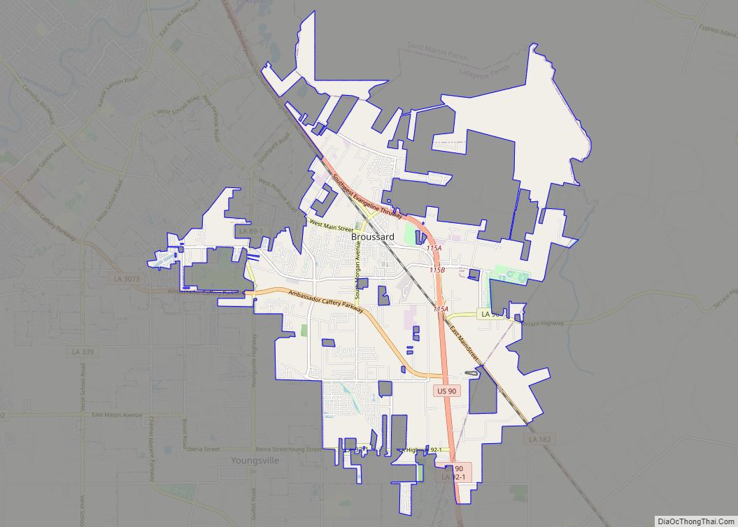
Broussard is a city in Lafayette and St. Martin parishes in the U.S. state of Louisiana. The population was 8,197 at the 2010 U.S. census, and 13,417 at the 2020 United States census. Broussard is part of the Lafayette metropolitan statistical area. Broussard city overview: Name: Broussard city LSAD Code: 25 LSAD Description: city (suffix) … Read more

Map of Bunkie city

Map of Bunkie city

Bunkie is a city in Avoyelles Parish, Louisiana, United States. The population was 4,171 at the 2010 census. Bunkie city overview: Name: Bunkie city LSAD Code: 25 LSAD Description: city (suffix) State: Louisiana County: Avoyelles Parish Elevation: 66 ft (20 m) Total Area: 3.04 sq mi (7.87 km²) Land Area: 3.02 sq mi (7.83 km²) Water Area: 0.01 sq mi (0.04 km²) Total Population: 3,346 Population … Read more

Map of Bryceland village

Map of Bryceland village

Bryceland is a village in Bienville Parish, Louisiana, United States. The population was 108 at the 2010 census. Bryceland village overview: Name: Bryceland village LSAD Code: 47 LSAD Description: village (suffix) State: Louisiana County: Bienville Parish Elevation: 308 ft (94 m) Total Area: 2.34 sq mi (6.06 km²) Land Area: 2.33 sq mi (6.04 km²) Water Area: 0.01 sq mi (0.02 km²) Total Population: 87 Population … Read more

Map of Brusly town

Map of Brusly town

Brusly is a town in West Baton Rouge Parish, Louisiana, United States. The population was 2,589 at the 2010 census. It is part of the Baton Rouge Metropolitan Statistical Area. Brusly town overview: Name: Brusly town LSAD Code: 43 LSAD Description: town (suffix) State: Louisiana County: West Baton Rouge Parish Elevation: 23 ft (7 m) Total Area: … Read more

Map of Calhoun CDP, Louisiana

Map of Calhoun CDP, Louisiana

Calhoun is an unincorporated community and census-designated place in Ouachita Parish, Louisiana, United States. It is named after Archibald Calhoun, who was an original settler and landowner. Its elevation is 177 feet (54 m), and it is located at 32°30′46″N 92°21′31″W / 32.51278°N 92.35861°W / 32.51278; -92.35861 (32.5126469, -92.3584744). Calhoun is unincorporated (no local government) and is … Read more

Map of Cade CDP

Map of Cade CDP

Cade is a census-designated place (CDP) in St. Martin Parish, Louisiana, United States. At the 2014 census estimates, Cade had a population of 1,188; in 2019, the American Community Survey estimated its population was 1,655. With the 2020 U.S. Census the population was 1874. The community is served by a single ZIP code: 70519. The … Read more

Map of Buras CDP

Map of Buras CDP

Buras is a census-designated place (CDP) in Plaquemines Parish, Louisiana, United States. Its population was 945 at the 2010 census, and 1,109 in 2020. Prior to the 2010 census, Buras was considered to be part of the Buras-Triumph CDP. Buras CDP overview: Name: Buras CDP LSAD Code: 57 LSAD Description: CDP (suffix) State: Louisiana County: … Read more

Map of Campti town

Map of Campti town

Campti is a town in the northern part of Natchitoches Parish, Louisiana, United States. The population was 1,056 at the 2010 census. It is part of the Natchitoches Micropolitan Statistical Area. Campti is a flat area of mostly farmland. It is located on the eastern bank of the Red River. Considerable herds of cattle are … Read more

Map of Cameron CDP, Louisiana

Map of Cameron CDP, Louisiana

Cameron is a census-designated place (CDP) in and the parish seat of Cameron Parish, Louisiana, United States. It is part of the Lake Charles Metropolitan Statistical Area. After sustaining extreme damage from Hurricane Rita in 2005 and Hurricane Ike in 2008, in the 2010 Census Cameron was recorded as having a population of only 406, … Read more

Map of Calvin village

Map of Calvin village, Louisiana

Calvin is a village in Winn Parish, Louisiana, United States. The population was 236 at the 2000 census. Calvin village overview: Name: Calvin village LSAD Code: 47 LSAD Description: village (suffix) State: Louisiana County: Winn Parish Elevation: 171 ft (52 m) Total Area: 2.29 sq mi (5.94 km²) Land Area: 2.29 sq mi (5.94 km²) Water Area: 0.00 sq mi (0.00 km²) Total Population: 242 Population … Read more

Map of Carlyss CDP

Map of Carlyss CDP

Carlyss (pronounced ‘car-liss’) is a census-designated place (CDP) in Calcasieu Parish, Louisiana, United States. The population was 5,101 in 2020. It is part of the Lake Charles metropolitan statistical area. Carlyss CDP overview: Name: Carlyss CDP LSAD Code: 57 LSAD Description: CDP (suffix) State: Louisiana County: Calcasieu Parish Elevation: 10 ft (3 m) Total Area: 11.10 sq mi (28.74 km²) … Read more

Map of Carencro city

Map of Carencro city

Carencro (/ˈkærənkroʊ/; historically French: St.-Pierre) is a city in Lafayette Parish, Louisiana, United States. It is a suburb of the nearby city of Lafayette. The population was 7,526 at the 2010 census, up from 6,120 in 2000; at the 2020 census, its population was 9,272. The name of the city is derived from the Cajun … Read more