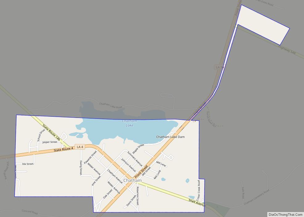
Map of Chauvin CDP

Map of Chauvin CDP

Chauvin is a census-designated place (CDP) in Terrebonne Parish, Louisiana, United States. The population was 2,575 in 2020.. It is part of the Houma–Bayou Cane–Thibodaux metropolitan statistical area. Chauvin CDP overview: Name: Chauvin CDP LSAD Code: 57 LSAD Description: CDP (suffix) State: Louisiana County: Terrebonne Parish Elevation: 3 ft (0.9 m) Total Area: 4.77 sq mi (12.35 km²) Land Area: … Read more

Map of Church Point town

Map of Church Point town

Church Point (French: Pointe-à-l’Église) is a town in Acadia Parish, Louisiana, United States. The population was 4,560 at the 2010 census. It is part of the Crowley Micropolitan Statistical Area. Church Point is known as the Buggy Capital of the World as it used to be host to the annual Buggy Festival which has since … Read more

Map of Choudrant village

Map of Choudrant village

Choudrant is a village in Lincoln Parish, Louisiana, United States. The population was 845 at the 2010 census. It is part of the Ruston Micropolitan Statistical Area. Choudrant village overview: Name: Choudrant village LSAD Code: 47 LSAD Description: village (suffix) State: Louisiana County: Lincoln Parish Elevation: 157 ft (48 m) Total Area: 4.28 sq mi (11.09 km²) Land Area: 4.23 sq mi … Read more

Map of Choctaw CDP

Map of Choctaw CDP, Louisiana

Choctaw is an unincorporated community and census-designated place in Lafourche Parish, Louisiana, United States. Its population was 879 as of the 2010 census. Choctaw CDP overview: Name: Choctaw CDP LSAD Code: 57 LSAD Description: CDP (suffix) State: Louisiana County: Lafourche Parish Elevation: 3 ft (0.9 m) Total Area: 6.25 sq mi (16.19 km²) Land Area: 6.25 sq mi (16.19 km²) Water Area: 0.00 sq mi … Read more

Map of Clarks village

Map of Clarks village, Louisiana

Clarks is a rural village in Caldwell Parish, Louisiana, United States. The population was 1,017 at the 2010 census. Clarks is the largest community by population in Caldwell Parish. Clarks village overview: Name: Clarks village LSAD Code: 47 LSAD Description: village (suffix) State: Louisiana County: Caldwell Parish Elevation: 141 ft (43 m) Total Area: 0.96 sq mi (2.49 km²) Land … Read more

Map of Clarence village, Louisiana

Map of Clarence village, Louisiana

Clarence is a village in Natchitoches Parish, Louisiana, United States. The population was 499 at the 2010 census. It is located some seven miles east of the parish seat of Natchitoches and is part of the Natchitoches Micropolitan Statistical Area. Still owned by descendants of its founders, Grayson Barbeque, with a smokehouse, is the best … Read more

Map of Claiborne CDP

Map of Claiborne CDP

Claiborne is an unincorporated community and census-designated place (CDP) in Ouachita Parish, Louisiana, United States. The population was 9,830 at the 2000 census. It is part of the Monroe Metropolitan Statistical Area. Claiborne CDP overview: Name: Claiborne CDP LSAD Code: 57 LSAD Description: CDP (suffix) State: Louisiana County: Ouachita Parish Elevation: 157 ft (48 m) Total Area: … Read more

Map of Colfax town, Louisiana

Map of Colfax town, Louisiana

Colfax is a town in, and the parish seat of, Grant Parish, Louisiana, United States, founded in 1869. Colfax is part of the Alexandria, Louisiana metropolitan area. The largely African American population of Colfax counted 1,558 at the 2010 census. Colfax town overview: Name: Colfax town LSAD Code: 43 LSAD Description: town (suffix) State: Louisiana … Read more

Map of Clinton town, Louisiana

Map of Clinton town, Louisiana

Clinton is a town in, and the parish seat of, East Feliciana Parish, Louisiana, United States. The town was named for New York Governor DeWitt Clinton. The population was 1,653 at the 2010 census. It is part of the Baton Rouge Metropolitan Statistical Area. Clinton town overview: Name: Clinton town LSAD Code: 43 LSAD Description: … Read more

Map of Clayton town, Louisiana

Map of Clayton town, Louisiana

Clayton is a town in northern Concordia Parish, Louisiana, United States. The population was 711 at the 2010 census. Cotton is a principal commodity in the area. Clayton is located on the Tensas River, important for fishing and boating, promoted through a U.S. Army Corps of Engineers-maintained boat launch. The Tensas River merges with the … Read more

Map of Convent CDP

Map of Convent CDP

Convent (French: Couvent) is a census-designated place in and the parish seat of St. James Parish, Louisiana, United States. It has been the parish seat since 1869. It is part of the New Orleans Metropolitan Area . As of the 2010 census, its population was 711, and 2018 estimates put the parish at 2174 people, … Read more

Map of Columbia town, Louisiana

Map of Columbia town, Louisiana

Columbia is a town in, and the parish seat of, Caldwell Parish, Louisiana, United States. The population was 277 in 2020. Columbia town overview: Name: Columbia town LSAD Code: 43 LSAD Description: town (suffix) State: Louisiana County: Caldwell Parish Founded: 1827 Elevation: 75 ft (23 m) Total Area: 0.77 sq mi (2.00 km²) Land Area: 0.76 sq mi (1.98 km²) Water Area: 0.01 sq mi … Read more