Map of Ferndale CDP, Maryland

Map of Ferndale CDP, Maryland

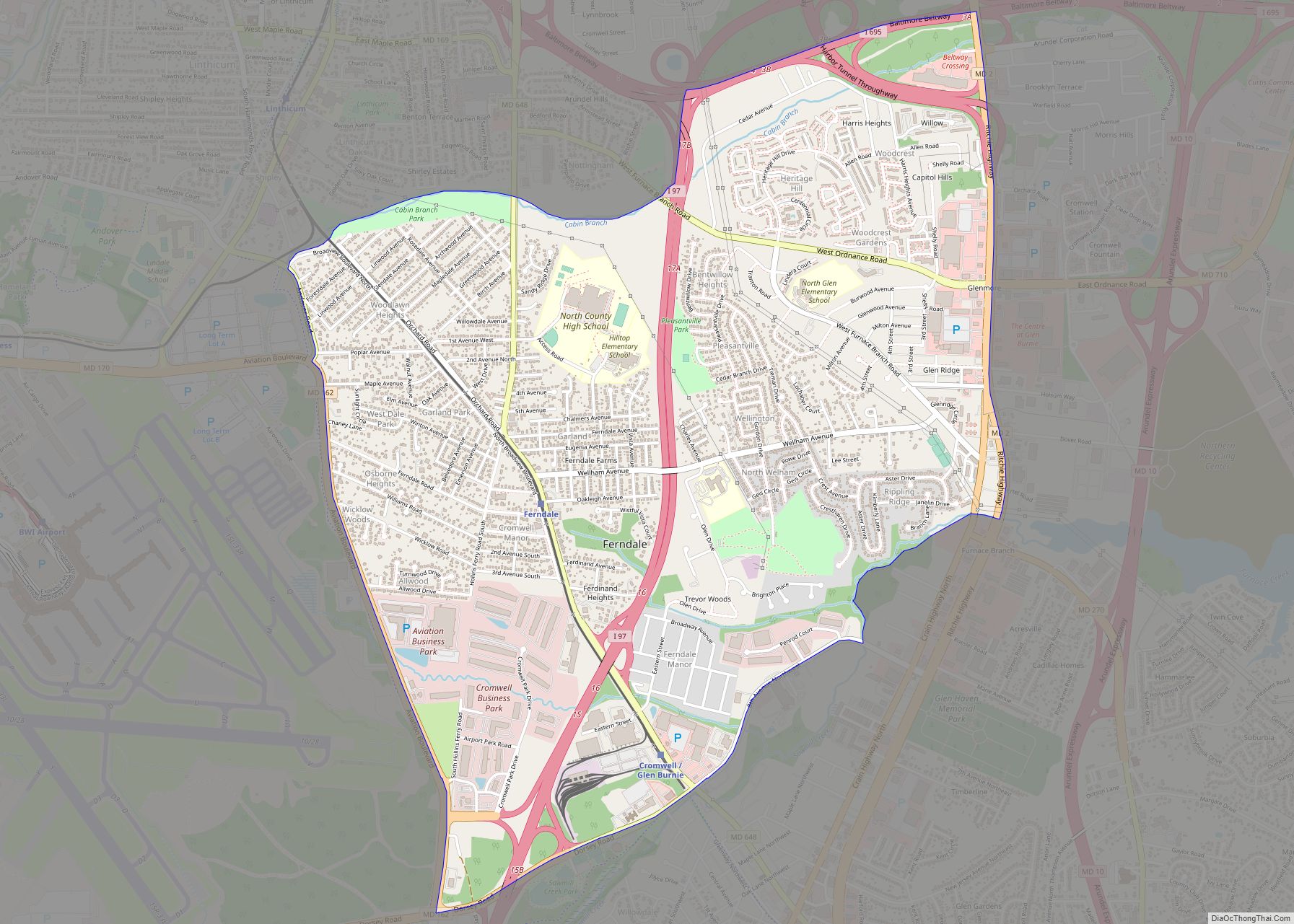
Ferndale is a census-designated place (CDP) in Anne Arundel County, Maryland, United States. At the 2010 census, the population was 16,746. Ferndale CDP overview: Name: Ferndale CDP LSAD Code: 57 LSAD Description: CDP (suffix) State: Maryland County: Anne Arundel County Elevation: 79 ft (24 m) Total Area: 3.96 sq mi (10.25 km²) Land Area: 3.96 sq mi (10.25 km²) Water Area: 0.00 sq mi (0.00 km²) … Read more

Map of Federalsburg town

Map of Federalsburg town

Federalsburg is a town in Caroline County, Maryland, United States. The population was 2,739 at the 2010 United States Census. It has one high school, Colonel Richardson High School. Federalsburg town overview: Name: Federalsburg town LSAD Code: 43 LSAD Description: town (suffix) State: Maryland County: Caroline County Incorporated: 1823 Elevation: 3 ft (1 m) Total Area: 1.99 sq mi … Read more

Map of Fallston CDP

Map of Fallston CDP, Maryland

Fallston is a census-designated place (CDP) in Harford County, Maryland, United States. The population was 8,958 at the 2010 census, up from 8,427 in 2000. Fallston is a semi-rural community consisting mostly of farms and suburban-like developments. Fallston CDP overview: Name: Fallston CDP LSAD Code: 57 LSAD Description: CDP (suffix) State: Maryland County: Harford County … Read more

Map of Flintstone CDP

Map of Flintstone CDP

Flintstone is an unincorporated community and census-designated place (CDP) in Allegany County, Maryland, United States. As of the 2010 census it had a population of 177. It is part of the Cumberland, MD-WV Metropolitan Statistical Area. Flintstone lies between the southern foot of Tussey Mountain and a water gap in Warrior Mountain formed by Flintstone … Read more

Map of Fishing Creek CDP

Map of Fishing Creek CDP

Fishing Creek is an unincorporated community and census-designated place (CDP) in Dorchester County, Maryland, United States, on Upper Hoopers Island. As of the 2010 census, the population of Fishing Creek was 163. It is in area code 410, and ZIP code 21634. Fishing Creek CDP overview: Name: Fishing Creek CDP LSAD Code: 57 LSAD Description: … Read more

Map of Finzel CDP

Map of Finzel CDP

Finzel is a census-designated place (CDP) in Garrett County, Maryland, United States. Finzel is located on Maryland Route 546 near the Pennsylvania border. As of the 2010 census, its population was 547. Finzel CDP overview: Name: Finzel CDP LSAD Code: 57 LSAD Description: CDP (suffix) State: Maryland County: Garrett County Elevation: 2,543 ft (775 m) Total Area: … Read more

Map of Forest Heights town

Map of Forest Heights town

Forest Heights is a town in Prince George’s County, Maryland, United States, and is part of the larger postal designation of Oxon Hill. The town straddles both sides of dual-lane Maryland Route 210 and includes two elementary schools. Per the 2020 census, the population was 2,658. Forest Heights town overview: Name: Forest Heights town LSAD … Read more

Map of Forest Glen CDP

Map of Forest Glen CDP

Forest Glen is a census-designated place (CDP) in Montgomery County, Maryland, United States. Its population was 6,897 as of the 2020 census. Forest Glen CDP overview: Name: Forest Glen CDP LSAD Code: 57 LSAD Description: CDP (suffix) State: Maryland County: Montgomery County Elevation: 315 ft (96 m) Total Area: 1.00 sq mi (2.60 km²) Land Area: 1.00 sq mi (2.60 km²) Water Area: … Read more

Map of Forestville CDP, Maryland

Map of Forestville CDP, Maryland

Forestville is an unincorporated area and census-designated place (CDP) in Prince George’s County, Maryland, United States. Per the 2020 census, the population was 12,831. The community is a mixture of garden apartments, single-family homes, and shopping centers built mostly from the 1930s through 1970s, adjacent to the communities of District Heights, Suitland, Morningside, Westphalia and … Read more

Map of Fort Washington CDP, Maryland

Map of Fort Washington CDP, Maryland

Fort Washington is an unincorporated area and census-designated place in Prince George’s County, Maryland, United States. It borders the Potomac River, situated 20 miles south of the downtown Washington, DC. As of the 2020 census it had a population of 24,261. The Fort Washington community is located west of Maryland Route 210, with some additional … Read more

Map of Fort Ritchie CDP

Map of Fort Ritchie CDP

Fort Ritchie is a census-designated place (CDP) in Washington County, Maryland, United States, just south of the Pennsylvania state line. The population was 276 at the 2000 census. Fort Ritchie is a former U.S. military base that closed in September 1998, pursuant to the 1995 Base Realignment and Closure Commission. Blue Ridge Summit, Pennsylvania is … Read more

Map of Fort Meade CDP, Maryland

Map of Fort Meade CDP, Maryland

Fort Meade is a census-designated place (CDP) in Anne Arundel County, Maryland, United States. The population was 9,327 at the 2010 census. It is the home to the National Security Agency, Central Security Service, United States Cyber Command and the Defense Information Systems Agency, which are located on the U.S. Army post Fort George G. … Read more