Map of Ocean CDP

Map of Ocean CDP

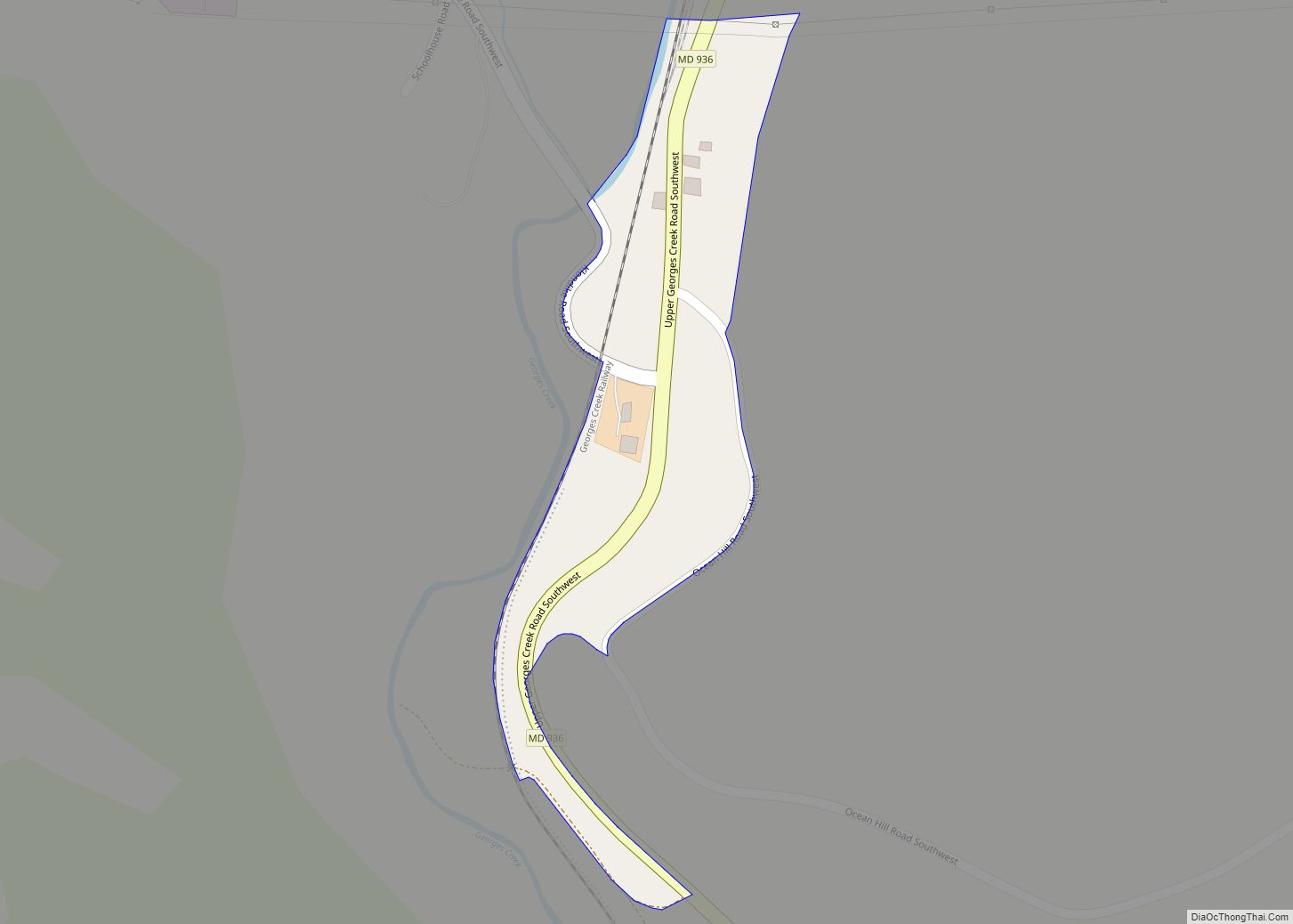
Ocean is an unincorporated community and census-designated place (CDP) in Allegany County, Maryland, United States. As of the 2010 census it had a population of 32. Ocean is located in the Georges Creek Valley of western Allegany County, along Maryland Route 936. Frostburg is 4 miles (6 km) to the north, and Lonaconing is 4 miles … Read more

Map of Ocean Pines CDP

Map of Ocean Pines CDP

Ocean Pines is a census-designated place (CDP) in Worcester County, Maryland, United States. The population was 11,710 at the 2010 census. It is part of the Salisbury, Maryland-Delaware Metropolitan Statistical Area. It shares the same ZIP code as Berlin. The community began as a small resort in 1968 and today is the largest residential community … Read more

Map of Ocean City town, Maryland

Map of Ocean City town, Maryland

Ocean City, officially the Town of Ocean City, is an Atlantic resort town in Worcester County, Maryland, along the East Coast of the United States. The population was 6,844 at the 2020 U.S. census, although during summer weekends the city hosts between 320,000 and 345,000 vacationers and up to eight million visitors annually. During the … Read more

Map of Olney CDP, Maryland

Map of Olney CDP, Maryland

Olney is a U.S. census-designated place and an unincorporated area in Montgomery County, Maryland. It is located in the north central part of the county, ten miles (16 km) north of Washington, D.C. Olney was largely agricultural until the 1960s, when growth of Washington, D.C.’s suburbs led to its conversion into a mostly residential area. It … Read more

Map of Oldtown CDP, Maryland

Map of Oldtown CDP, Maryland

Oldtown is an unincorporated community and census-designated place (CDP) in Allegany County, Maryland, United States, along the North Branch Potomac River. As of the 2010 census, it had a population of 86. Oldtown CDP overview: Name: Oldtown CDP LSAD Code: 57 LSAD Description: CDP (suffix) State: Maryland County: Allegany County Elevation: 580 ft (180 m) Total Area: … Read more

Map of Odenton CDP

Map of Odenton CDP

Odenton (/ˈoʊdəntən/ OH-dən-tən) is a census-designated place (CDP) in Anne Arundel County, Maryland, United States, located approximately 10–20 minutes from the state capital, Annapolis. The population was 37,132 at the 2010 census, up from 20,534 at the 2000 census. The town’s population growth rate of 80.8% between 2000 and 2010 was the greatest of any … Read more

Map of Owings Mills CDP

Map of Owings Mills CDP

Owings Mills is an unincorporated community and census-designated place in Baltimore County, Maryland, United States. It is a suburb of Baltimore. Per the 2020 census, the population was 35,674. Owings Mills is home to the northern terminus of the Baltimore Metro Subway, and housed the Owings Mills Mall until its closure in 2015. It is … Read more

Map of Overlea CDP

Map of Overlea CDP

Overlea /ˈoʊvərˌliː/ is an unincorporated community and census-designated place in Baltimore County, Maryland, United States. The population was 12,275 at the 2010 census. Students attend Overlea High School. Area roads include Belair Road (U.S. Route 1) and Kenwood Avenue (Maryland Route 588). Overlea includes the neighborhood of Fullerton. Overlea CDP overview: Name: Overlea CDP LSAD … Read more

Map of Owings CDP

Map of Owings CDP

Owings is a town center and census-designated place (CDP) in northern Calvert County, Maryland, United States. The population was 2,149 at the 2010 census, up from 1,325 in 2000. Owings CDP overview: Name: Owings CDP LSAD Code: 57 LSAD Description: CDP (suffix) State: Maryland County: Calvert County Elevation: 89 ft (27 m) Total Area: 3.95 sq mi (10.23 km²) Land … Read more

Map of Paramount-Long Meadow CDP

Map of Paramount-Long Meadow CDP

Paramount-Long Meadow is a census-designated place (CDP) in Washington County, Maryland, United States. The population was 2,722 at the 2000 census. Paramount-Long Meadow CDP overview: Name: Paramount-Long Meadow CDP LSAD Code: 57 LSAD Description: CDP (suffix) State: Maryland County: Washington County Total Area: 2.18 sq mi (5.65 km²) Land Area: 2.18 sq mi (5.65 km²) Water Area: 0.00 sq mi (0.00 km²) Total Population: … Read more

Map of Oxon Hill CDP

Map of Oxon Hill CDP

Oxon Hill is an unincorporated area and census-designated place (CDP) in southern Prince George’s County, Maryland, United States. Oxon Hill is a suburb of Washington, located southeast of the downtown district and east of Alexandria, Virginia. It contains the new 300-acre (120 ha) National Harbor development on the shore of the Potomac River. For the 1990 … Read more

Map of Oxford town, Maryland

Map of Oxford town, Maryland

Oxford is a waterfront town and former colonial port in Talbot County, Maryland, United States. The population was 651 at the 2010 census. Oxford town overview: Name: Oxford town LSAD Code: 43 LSAD Description: town (suffix) State: Maryland County: Talbot County Founded: 1683 (officially) Elevation: 7 ft (2 m) Total Area: 0.84 sq mi (2.17 km²) Land Area: 0.56 sq mi (1.45 km²) … Read more