Map of Reisterstown CDP

Map of Reisterstown CDP

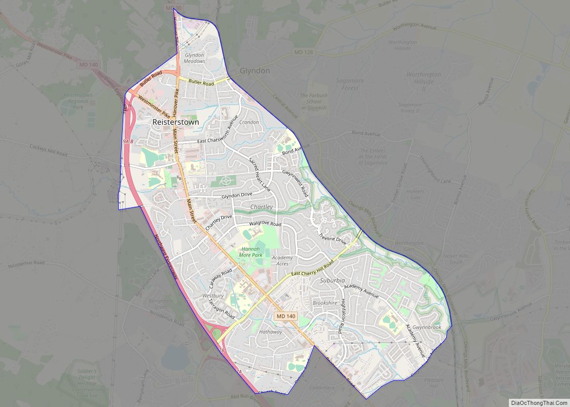
Reisterstown is an unincorporated community and census-designated place in Baltimore County, Maryland, United States. As of the 2010 census, it had a population of 25,968. Founded by German immigrant John Reister in 1758, Reisterstown is located to the northwest of Baltimore. Though it is older than the surrounding areas, it now serves primarily as a … Read more

Map of Reid CDP

Map of Reid CDP

Reid is an unincorporated community and census-designated place in Washington County, Maryland, United States. Its population was 64 as of the 2020 census. Reid CDP overview: Name: Reid CDP LSAD Code: 57 LSAD Description: CDP (suffix) State: Maryland County: Washington County Total Area: 0.13 sq mi (0.32 km²) Land Area: 0.13 sq mi (0.32 km²) Water Area: 0.00 sq mi (0.00 km²) Total Population: … Read more

Map of Redland CDP, Maryland

Map of Redland CDP, Maryland

Redland is a census-designated place and an unincorporated area in Montgomery County, Maryland, United States. It had a population of 18,592 as of the 2020 census. Redland CDP overview: Name: Redland CDP LSAD Code: 57 LSAD Description: CDP (suffix) State: Maryland County: Montgomery County Elevation: 492 ft (150 m) Total Area: 7.35 sq mi (19.02 km²) Land Area: 7.19 sq mi (18.63 km²) … Read more

Map of Rising Sun town, Maryland

Map of Rising Sun town, Maryland

Rising Sun is a town in Cecil County, Maryland, United States. The population was 2,781 at the 2010 census. Rising Sun town overview: Name: Rising Sun town LSAD Code: 43 LSAD Description: town (suffix) State: Maryland County: Cecil County Incorporated: 1860 Elevation: 390 ft (119 m) Total Area: 1.66 sq mi (4.29 km²) Land Area: 1.63 sq mi (4.21 km²) Water Area: 0.03 sq mi … Read more

Map of Ringgold CDP, Maryland

Map of Ringgold CDP, Maryland

Ringgold is an unincorporated community and census-designated place in Washington County, Maryland, United States. Its population was 166 as of the 2010 census. Ringgold CDP overview: Name: Ringgold CDP LSAD Code: 57 LSAD Description: CDP (suffix) State: Maryland County: Washington County Elevation: 764 ft (233 m) Total Area: 0.29 sq mi (0.75 km²) Land Area: 0.29 sq mi (0.75 km²) Water Area: 0.00 sq mi … Read more

Map of Ridgely town

Map of Ridgely town, Maryland

Ridgely is a town in Caroline County, Maryland, United States. The population was 1,639 at the 2010 census. Ridgely town overview: Name: Ridgely town LSAD Code: 43 LSAD Description: town (suffix) State: Maryland County: Caroline County Incorporated: 1896 Elevation: 59 ft (18 m) Total Area: 1.86 sq mi (4.83 km²) Land Area: 1.86 sq mi (4.83 km²) Water Area: 0.00 sq mi (0.00 km²) Total Population: … Read more

Map of Riverside CDP, Maryland

Map of Riverside CDP, Maryland

Riverside is a census-designated place (CDP) in Harford County, Maryland, United States. The population was 6,425 at the 2010 census. The term “Riverside” is generally used interchangeably with “Belcamp”; both names are accepted for the U.S. Postal Service’s ZIP Code of 21017. However, the original community of Belcamp is located south of U.S. Route 40, … Read more

Map of Riverdale Park town, Maryland

Map of Riverdale Park town, Maryland

Riverdale Park, formerly known and often referred to as Riverdale, is a semi-urban town in Prince George’s County, Maryland, United States, a suburb in the Washington, D.C. metropolitan area. The population was 6,955 as of the 2010 U.S. Census. The population as of 2019 is approximately 7,304, according to the US Census Bureau and other … Read more

Map of Riva CDP

Map of Riva CDP

Riva is a census-designated place (CDP) in Anne Arundel County, Maryland, United States. The population was 4,076 at the 2010 census. The area is scenic, especially where the two-lane Riva Road crosses the South River on a bridge. The area is growing with large new homes as the suburbs of Annapolis grow outward. Riva is … Read more

Map of Rock Hall town

Map of Rock Hall town

Rock Hall, is a waterfront town located directly on the National Chesapeake Scenic Byway in Kent County, Maryland, United States. The population was 1,310 at the 2010 census. Rock Hall town overview: Name: Rock Hall town LSAD Code: 43 LSAD Description: town (suffix) State: Maryland County: Kent County Founded: 1707 Incorporated: 1908 Elevation: 10 ft (3 m) … Read more

Map of Robinwood CDP

Map of Robinwood CDP

Robinwood is a census-designated place (CDP) in Washington County, Maryland, United States. The population was 4,731 at the 2000 census. It is a part of the Hagerstown Metropolitan Area. Robinwood is home to Hagerstown Community College. Robinwood CDP overview: Name: Robinwood CDP LSAD Code: 57 LSAD Description: CDP (suffix) State: Maryland County: Washington County Total … Read more

Map of Riviera Beach CDP, Maryland

Map of Riviera Beach CDP, Maryland

Riviera Beach is a census-designated place in Anne Arundel County, Maryland, United States. The population was 12,677 at the 2010 U.S. census. Riviera Beach CDP overview: Name: Riviera Beach CDP LSAD Code: 57 LSAD Description: CDP (suffix) State: Maryland County: Anne Arundel County Elevation: 10 ft (3 m) Total Area: 3.21 sq mi (8.31 km²) Land Area: 2.63 sq mi (6.81 km²) Water … Read more