Map of Cabin John CDP

Map of Cabin John CDP

Cabin John is a census-designated place and an unincorporated area in Montgomery County, Maryland, United States. Its original southern boundary encompassed a section of the Chesapeake and Ohio Canal (C&O) including locks 8–12, and the northern shore of the Potomac River. It is also the access point to Plummers Island, originally owned by The Washington … Read more

Map of Butlertown CDP

Map of Butlertown CDP

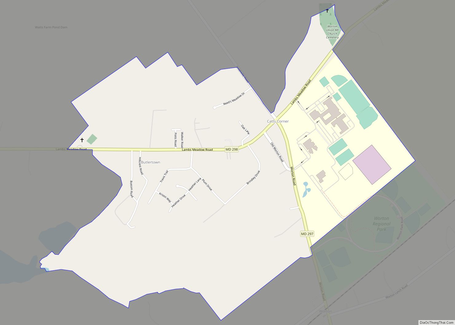
Butlertown is an unincorporated community and census-designated place in Kent County, Maryland, United States. Per the 2020 census, the population was 520. Butlertown CDP overview: Name: Butlertown CDP LSAD Code: 57 LSAD Description: CDP (suffix) State: Maryland County: Kent County Elevation: 82 ft (25 m) Total Area: 0.82 sq mi (2.14 km²) Land Area: 0.82 sq mi (2.12 km²) Water Area: 0.01 sq mi (0.02 km²) … Read more

Map of Burtonsville CDP

Map of Burtonsville CDP

Burtonsville is a census-designated place and an unincorporated area in Montgomery County, Maryland, United States. It is situated in the northeast corner of Montgomery County, right on the border of both Howard and Prince George’s counties. It is considered a suburban town in the Washington D.C. Metro Area. It is 20 miles southwest of downtown … Read more

Map of Calverton CDP

Map of Calverton CDP, Maryland

Calverton is an unincorporated area and census-designated place located on the boundary between Montgomery and Prince George’s counties, Maryland, in the United States. At the 2020 census, it had a population of 17,316. Calverton CDP overview: Name: Calverton CDP LSAD Code: 57 LSAD Description: CDP (suffix) State: Maryland County: Montgomery County, Prince George’s County Elevation: … Read more

Map of Calvert Beach CDP

Map of Calvert Beach CDP

Calvert Beach is a census-designated place and unincorporated community in Calvert County, Maryland, United States. Its population was 808 as of the 2010 census. Prior to 2010, the community was part of the Calvert Beach-Long Beach CDP. Calvert Beach CDP overview: Name: Calvert Beach CDP LSAD Code: 57 LSAD Description: CDP (suffix) State: Maryland County: … Read more

Map of California CDP, Maryland

Map of California CDP, Maryland

California is a census-designated place and community in St. Mary’s County, Maryland, United States. The population was 11,857 at the 2010 census, an increase of 27.4% from the 2000 census. California has been growing with the spread of population from the older adjacent community of Lexington Park and the growth in both technology-related and defense-related … Read more

Map of Cape St. Claire CDP

Map of Cape St. Claire CDP

Cape St. Claire CDP overview: Name: Cape St. Claire CDP LSAD Code: 57 LSAD Description: CDP (suffix) State: Maryland County: Anne Arundel County FIPS code: 2412912 Online Interactive Map Cape St. Claire online map. Source: Basemap layers from Google Map, Open Street Map (OSM), Arcgisonline, Wmflabs. Boundary Data from Database of Global Administrative Areas. Cape … Read more

Map of Camp Springs CDP

Map of Camp Springs CDP

Camp Springs is an unincorporated area and census-designated place (CDP) in Prince George’s County, Maryland, United States. The population was 22,734 at the 2020 census. Camp Springs is not an official post office designation; the area is divided among the surrounding mailing addresses of Temple Hills, Fort Washington, Clinton, and Suitland. Camp Springs CDP overview: … Read more

Map of Cambridge city, Maryland

Map of Cambridge city, Maryland

Cambridge is a city in Dorchester County, Maryland, United States. The population was 13,096 at the 2020 census. It is the county seat of Dorchester County and the county’s largest municipality. Cambridge is the fourth most populous city in Maryland’s Eastern Shore region, after Salisbury, Elkton and Easton. Cambridge city overview: Name: Cambridge city LSAD … Read more

Map of Carney CDP

Map of Carney CDP, Maryland

Carney is an unincorporated community and census-designated place in Baltimore County, Maryland, United States. The population was 29,941 at the 2010 census. Carney CDP overview: Name: Carney CDP LSAD Code: 57 LSAD Description: CDP (suffix) State: Maryland County: Baltimore County Elevation: 354 ft (108 m) Total Area: 7.01 sq mi (18.15 km²) Land Area: 7.01 sq mi (18.15 km²) Water Area: 0.00 sq mi (0.01 km²) … Read more

Map of Carlos CDP

Map of Carlos CDP, Maryland

Carlos is an unincorporated community and census-designated place (CDP) in Allegany County, Maryland, United States. As of the 2010 census it had a population of 153. Carlos is located 3 miles (5 km) southwest of Frostburg near the western border of Allegany County, at the foot of Big Savage Mountain. Carlos CDP overview: Name: Carlos CDP … Read more

Map of Capitol Heights town

Map of Capitol Heights town

Capitol Heights is a town in Prince George’s County, Maryland, United States, located on the border of both the Northeast & Southeast quadrants of Washington. Per the 2020 census, the population was 4,050. The town of Capitol Heights is officially bounded between Southern Avenue NE/SE to the north, Yost Place, and Eastern Avenue NE to … Read more