Map of Lenox CDP, Massachusetts

Map of Lenox CDP, Massachusetts

Lenox, also known as Lenox Center, is a census-designated place (CDP) in the town of Lenox in Berkshire County, Massachusetts, United States. The population was 1,675 at the 2010 census, out of 5,025 in the entire town of Lenox. Lenox CDP overview: Name: Lenox CDP LSAD Code: 57 LSAD Description: CDP (suffix) State: Massachusetts County: … Read more

Map of Lee CDP, Massachusetts

Map of Lee CDP, Massachusetts

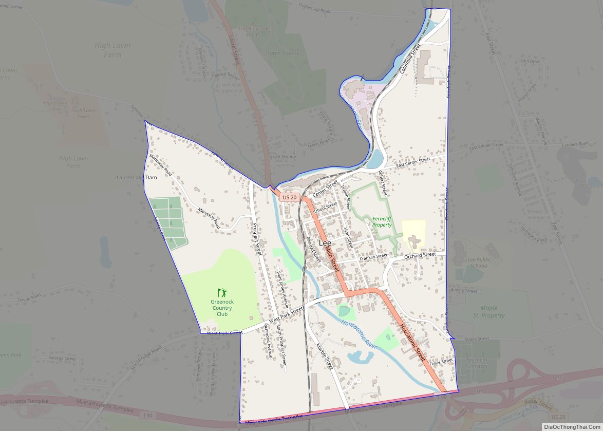
Lee is a census-designated place (CDP) located in the town of Lee in Berkshire County, Massachusetts, United States. The population was 2,051 at the 2010 census, out of 5,943 in the entire town of Lee. Lee CDP overview: Name: Lee CDP LSAD Code: 57 LSAD Description: CDP (suffix) State: Massachusetts County: Berkshire County Elevation: 883 ft … Read more

Map of Littleton Common CDP

Map of Littleton Common CDP

Littleton Common is a census-designated place (CDP) in the town of Littleton in Middlesex County, Massachusetts, United States. The population was 2,789 at the 2010 census. Littleton Common CDP overview: Name: Littleton Common CDP LSAD Code: 57 LSAD Description: CDP (suffix) State: Massachusetts County: Middlesex County Elevation: 266 ft (81 m) Total Area: 3.70 sq mi (9.59 km²) Land Area: … Read more

Map of Lexington CDP, Massachusetts

Map of Lexington CDP, Massachusetts

Lexington is a suburban town in Middlesex County, Massachusetts, United States, located 10 miles (16 km) from Downtown Boston. The population was 34,454 as of the 2020 census. The area was originally inhabited by Native Americans, and was first settled by Europeans in 1641 as a farming community. Lexington is well known as the site of … Read more

Map of Leominster city

Map of Leominster city

Leominster (/ˈlɛmənstər/ LEM-ən-stər) is a city in Worcester County, Massachusetts, United States. It is the second-largest city in Worcester County, with a population of 43,782 at the 2020 census. Leominster is located north of Worcester and northwest of Boston. Both Route 2 and Route 12 pass through Leominster. Interstate 190, Route 13, and Route 117 … Read more

Map of Lynn city, Massachusetts

Map of Lynn city, Massachusetts

Lynn is the eighth-largest municipality in Massachusetts, United States, and the largest city in Essex County. Situated on the Atlantic Ocean, 3.7 miles (6.0 km) north of the Boston city line at Suffolk Downs, Lynn is part of Greater Boston’s urban inner core. Settled by Europeans in 1629, Lynn is the 5th oldest colonial settlement in … Read more

Map of Lunenburg CDP

Map of Lunenburg CDP, Massachusetts

Lunenburg is a census-designated place (CDP) in the town of Lunenburg in Worcester County, Massachusetts, United States. The population was 1,760 at the 2010 census. Lunenburg CDP overview: Name: Lunenburg CDP LSAD Code: 57 LSAD Description: CDP (suffix) State: Massachusetts County: Worcester County Elevation: 571 ft (174 m) Total Area: 3.80 sq mi (9.84 km²) Land Area: 3.80 sq mi (9.84 km²) Water … Read more

Map of Longmeadow CDP

Map of Longmeadow CDP

Longmeadow is a town in Hampden County, Massachusetts, in the United States. The population was 15,853 at the 2020 census. Longmeadow CDP overview: Name: Longmeadow CDP LSAD Code: 57 LSAD Description: CDP (suffix) State: Massachusetts County: Hampden County Incorporated: 1783 Elevation: 160 ft (49 m) Total Area: 9.7 sq mi (25.0 km²) Land Area: 9.1 sq mi (23.6 km²) Water Area: 0.5 sq mi (1.3 km²) … Read more

Map of Malden city, Massachusetts

Map of Malden city, Massachusetts

Malden is a city in Middlesex County, Massachusetts, United States. At the time of the 2020 U.S. Census, the population was 66,263 people. Malden city overview: Name: Malden city LSAD Code: 25 LSAD Description: city (suffix) State: Massachusetts County: Middlesex County Incorporated: 1649 Elevation: 13 ft (4 m) Total Area: 5.08 sq mi (13.16 km²) Land Area: 5.04 sq mi (13.06 km²) Water … Read more

Map of Madaket CDP

Map of Madaket CDP

Madaket (also Madaquet, Maddaket, Maddequet, Madeket, or Mattaket) is a census designated place (CDP) in Nantucket, Massachusetts, United States. The population was 236 at the 2010 census. Its elevation is 26 feet (8 m) on the western end of the island. The various spellings of its name led the Board on Geographic Names to designate its official … Read more

Map of Lynnfield CDP

Map of Lynnfield CDP

Lynnfield is a town in Essex County, Massachusetts, in the United States. At the 2020 census, the town population was 13,000. Lynnfield initially consisted of two distinct villages with a single governing body. Lynnfield Center comprises mostly an agricultural population, while South Lynnfield boasted a mixed culture. Together, the two towns evolved into one of … Read more

Map of Marion Center CDP

Map of Marion Center CDP, Massachusetts

Marion Center is a census-designated place (CDP) in the town of Marion in Plymouth County, Massachusetts, United States. The population was 1,111 at the 2010 census. Marion Center CDP overview: Name: Marion Center CDP LSAD Code: 57 LSAD Description: CDP (suffix) State: Massachusetts County: Plymouth County Total Area: 1.12 sq mi (2.90 km²) Land Area: 1.02 sq mi (2.65 km²) Water … Read more