Map of Fowler village, Michigan

Map of Fowler village, Michigan

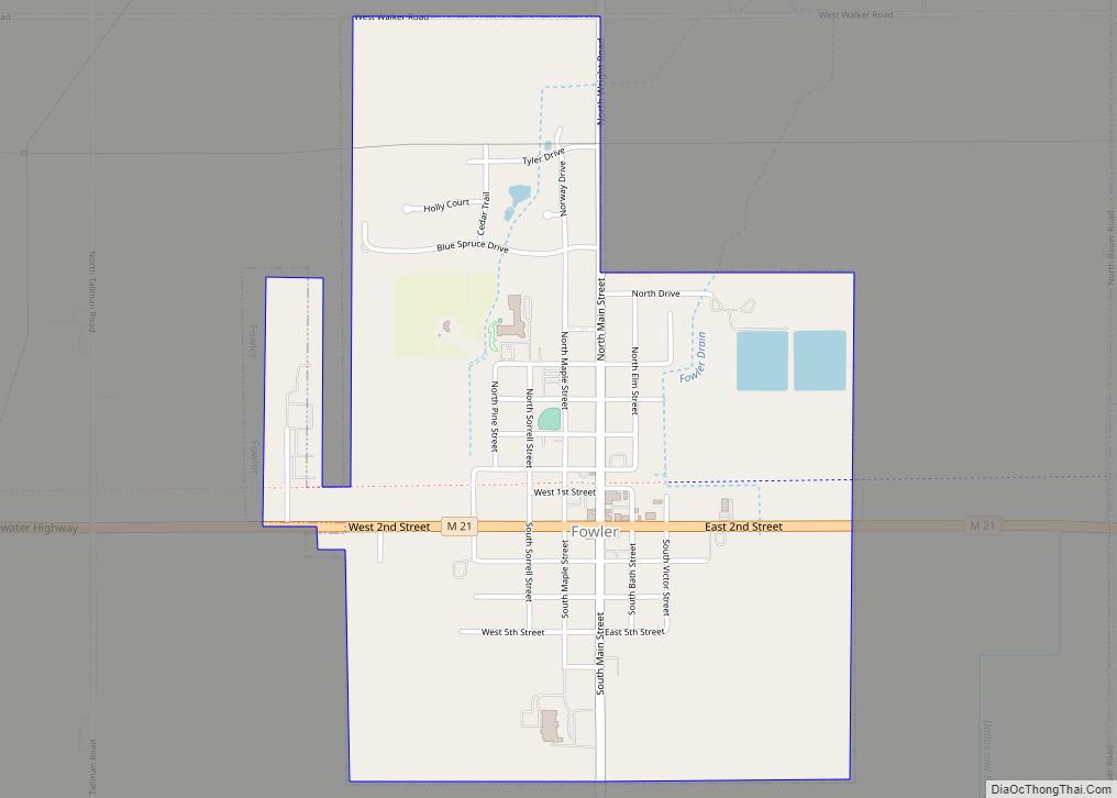
Fowler is a village in Clinton County in the U.S. state of Michigan. The population was 1,226 at the 2020 census. The village is located within Dallas Township. Fowler village overview: Name: Fowler village LSAD Code: 47 LSAD Description: village (suffix) State: Michigan County: Clinton County Incorporated: 1885 Elevation: 745 ft (227 m) Total Area: 1.31 sq mi (3.39 km²) … Read more

Map of Fountain village, Michigan

Map of Fountain village, Michigan

Fountain is a village in Mason County in the U.S. state of Michigan. The population was 193 at the 2010 census. The village is within Sherman Township. Fountain village overview: Name: Fountain village LSAD Code: 47 LSAD Description: village (suffix) State: Michigan County: Mason County Founded: 1882 Incorporated: 1913 Elevation: 709 ft (216 m) Total Area: 1.02 sq mi … Read more

Map of Fostoria CDP, Michigan

Map of Fostoria CDP, Michigan

Fostoria is an unincorporated community and census-designated place in Watertown Township, Tuscola County, Michigan, United States. Its population was 694 as of the 2010 census. Fostoria has a post office with ZIP code 48435. Fostoria CDP overview: Name: Fostoria CDP LSAD Code: 57 LSAD Description: CDP (suffix) State: Michigan County: Tuscola County Elevation: 853 ft (260 m) … Read more

Map of Forestville village, Michigan

Map of Forestville village, Michigan

Forestville is a village in Sanilac County in the U.S. state of Michigan. The population was 136 at the 2010 census. It does not have a true harbor onto Lake Huron, but the village does have a boat launch site. Forestville receives city water from nearby Harbor Beach. The village is within Delaware Township. Forestville … Read more

Map of Forest Hills CDP, Michigan

Map of Forest Hills CDP, Michigan

Forest Hills is an unincorporated community and census-designated place (CDP) in Kent County in the U.S. state of Michigan. The population was 25,867 at the 2010 census. Forest Hills is the most-populated CDP and also the largest by area in the state of Michigan. The CDP encompasses nearly all of Ada Township and most of … Read more

Map of Fraser city, Michigan

Map of Fraser city, Michigan

Fraser is a city in Macomb County of the U.S. state of Michigan. The population was 14,480 at the 2010 census. The city is part of the Metro Detroit region. Fraser city overview: Name: Fraser city LSAD Code: 25 LSAD Description: city (suffix) State: Michigan County: Macomb County Elevation: 610 ft (186 m) Total Area: 4.16 sq mi (10.77 km²) … Read more

Map of Franklin village, Michigan

Map of Franklin village, Michigan

Franklin is a village in Southfield Township, Oakland County in the U.S. state of Michigan. The population was 3,150 at the 2010 census. The community is known for large, estate-style homes. The downtown was designated as an historic district, the first in Michigan, and listed on the National Register of Historic Places in 1969. The … Read more

Map of Frankfort city, Michigan

Map of Frankfort city, Michigan

Frankfort is a city in the U.S. state of Michigan. Located within Benzie County, the city sits upon the shore of Lake Michigan at the mouth of the Betsie River. The city had a population of 1,252 at the 2020 census. Frankfort city overview: Name: Frankfort city LSAD Code: 25 LSAD Description: city (suffix) State: … Read more

Map of Frankenmuth city

Map of Frankenmuth city

Frankenmuth is a city in Saginaw County in the U.S. state of Michigan. The population was 4,987 at the 2020 census. The city is surrounded by Frankenmuth Township. Bronner’s Christmas Wonderland, which bills itself as “the World’s Largest Christmas Store”, is located in Frankenmuth. The city’s name is a combination of two words. Franken represents … Read more

Map of Fowlerville village

Map of Fowlerville village, Michigan

Fowlerville is a village in Livingston County in the U.S. state of Michigan. It is located in the northeast portion of Handy Township, but is politically independent from the township. The population was 2,886 at the time of the 2010 census. Fowlerville is home to several notable events such as Christmas in the ‘Ville, Memorial … Read more

Map of Freeport village, Michigan

Map of Freeport village, Michigan

Freeport is a village in Barry County in the U.S. state of Michigan. The population was 483 at the 2010 census. The village is mostly within Irving Township, though a small portion lies in Carlton Township. Freeport village overview: Name: Freeport village LSAD Code: 47 LSAD Description: village (suffix) State: Michigan County: Barry County Elevation: … Read more

Map of Freeland CDP

Map of Freeland CDP, Michigan

Freeland is a census-designated place in Tittabawassee Township, Saginaw County in the U.S. state of Michigan. It is part of the Saginaw-Midland-Bay Metropolitan Area. As of the 2000 census, the CDP population was 5,147. The CDP covers an area in the central portion of Tittabawassee Township. The Freeland post office, ZIP code 48623, serves nearly … Read more