Map of Freeport village, Michigan
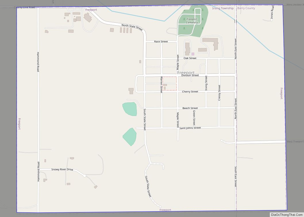
Freeport is a village in Barry County in the U.S. state of Michigan. The population was 483 at the 2010 census. The village is mostly within Irving Township, though a small portion lies in Carlton Township. Freeport village overview: Name: Freeport village LSAD Code: 47 LSAD Description: village (suffix) State: Michigan County: Barry County Elevation: ... Read more
Map of Freeport village, Michigan
Map of Freeland CDP, Michigan
Freeland is a census-designated place in Tittabawassee Township, Saginaw County in the U.S. state of Michigan. It is part of the Saginaw-Midland-Bay Metropolitan Area. As of the 2000 census, the CDP population was 5,147. The CDP covers an area in the central portion of Tittabawassee Township. The Freeland post office, ZIP code 48623, serves nearly ... Read more
Map of Freeland CDP, Michigan
Map of Free Soil village
Free Soil is a village in Mason County in the U.S. state of Michigan. The population was 144 at the 2010 census. The village is located within Free Soil Township. Free Soil village overview: Name: Free Soil village LSAD Code: 47 LSAD Description: village (suffix) State: Michigan County: Mason County Incorporated: 1912 Elevation: 686 ft (209 m) ... Read more
Map of Free Soil village
Map of Galien village
Galien (pronounced guh-LEEN) is a village in Berrien County in the U.S. state of Michigan. The population was 549 at the 2010 census. The village is located within Galien Township. The village provides its own sewer utility. Galien village overview: Name: Galien village LSAD Code: 47 LSAD Description: village (suffix) State: Michigan County: Berrien County ... Read more
Map of Galien village
Map of Galesburg city, Michigan
Galesburg is a city in Kalamazoo County in the U.S. state of Michigan. The population was 2,009 at the 2010 census. Galesburg is located along the north side of the Kalamazoo River. The city is situated on M-96 and is just north of I-94 (with exits due south of the city’s west side and about ... Read more
Map of Galesburg city, Michigan
Map of Gaines village
Gaines is a village in Genesee County in the U.S. state of Michigan. The population was 380 at the 2010 census. The village is within Gaines Township. Gaines village overview: Name: Gaines village LSAD Code: 47 LSAD Description: village (suffix) State: Michigan County: Genesee County Incorporated: 1875 Elevation: 856 ft (261 m) Total Area: 0.37 sq mi (0.97 km²) Land ... Read more
Map of Gaines village
Map of Gagetown village
Gagetown is a village in Tuscola County in the U.S. state of Michigan. The population was 388 at the 2010 census. It is located in the northeastern corner of Elmwood Township. Gagetown is northeast of the Saginaw metropolitan area as well as the city of Caro. Gagetown village overview: Name: Gagetown village LSAD Code: 47 ... Read more
Map of Gagetown village
Map of Gaastra city
Gaastra is a city in Iron County in the U.S. state of Michigan. As of the 2010 census, the city population was 347, making it Michigan’s third-smallest incorporated city by population after Omer (259) and Lake Angelus (290). Gaastra city overview: Name: Gaastra city LSAD Code: 25 LSAD Description: city (suffix) State: Michigan County: Iron ... Read more
Map of Gaastra city
Map of Gaylord city, Michigan
Gaylord (/ɡeɪlərd/ GAY-lərd) is a city in the U.S. state of Michigan. It is the county seat of Otsego County, and is the only city within the county. Gaylord had a population of 4,286 at the 2020 census, an increase from 3,645 at the 2010 census. Gaylord styles itself as an “alpine village” and contains ... Read more
Map of Gaylord city, Michigan
Map of Garden village, Michigan
Garden is a village in Delta County of the U.S. state of Michigan. The population was 221 at the 2010 census. The village is located within Garden Township. M-183 runs through the village, connecting with Fayette eight miles (13 km) southwest and with U.S. Highway 2 at Garden Corners, nine miles (14 km) to the north. Garden ... Read more
Map of Garden village, Michigan
Map of Garden City, Michigan
Garden City is a city in Wayne County of the U.S. state of Michigan. As of the 2010 census, the city population was 27,692. The city is part of the Metro Detroit region and is approximately 10 miles (16.1 km) west of the city of Detroit. M-153 (Ford Road) runs east–west through the center of the ... Read more
Map of Garden City, Michigan
Map of Gladstone city, Michigan
Gladstone is a city in Delta County in the Upper Peninsula of the U.S. state of Michigan. First settled in 1877, Gladstone’s original name was Minnewasca. The population is 5,257 according to the 2020 census. U.S. Highways 2 and 41 run concurrently through the city, connecting with Escanaba, nine miles (14 km) to the south. US ... Read more
Map of Gladstone city, Michigan