Map of Honor village

Map of Honor village

Honor is a village in Benzie County of the U.S. state of Michigan. The population was 337 at the 2020 census. The village is located within Homestead Township on U.S. Highway 31 along the Platte River. The community has the name of Honor Griffin, the daughter of a first settler. Honor village overview: Name: Honor … Read more

Map of Homer village, Michigan

Map of Homer village, Michigan

Homer is a village in Calhoun County in the U.S. state of Michigan. It is part of the Battle Creek, Michigan Metropolitan Statistical Area. The population was 1,668 at the 2010 census. Homer village overview: Name: Homer village LSAD Code: 47 LSAD Description: village (suffix) State: Michigan County: Calhoun County Elevation: 991 ft (302 m) Total Area: … Read more

Map of Holt CDP, Michigan

Map of Holt CDP, Michigan

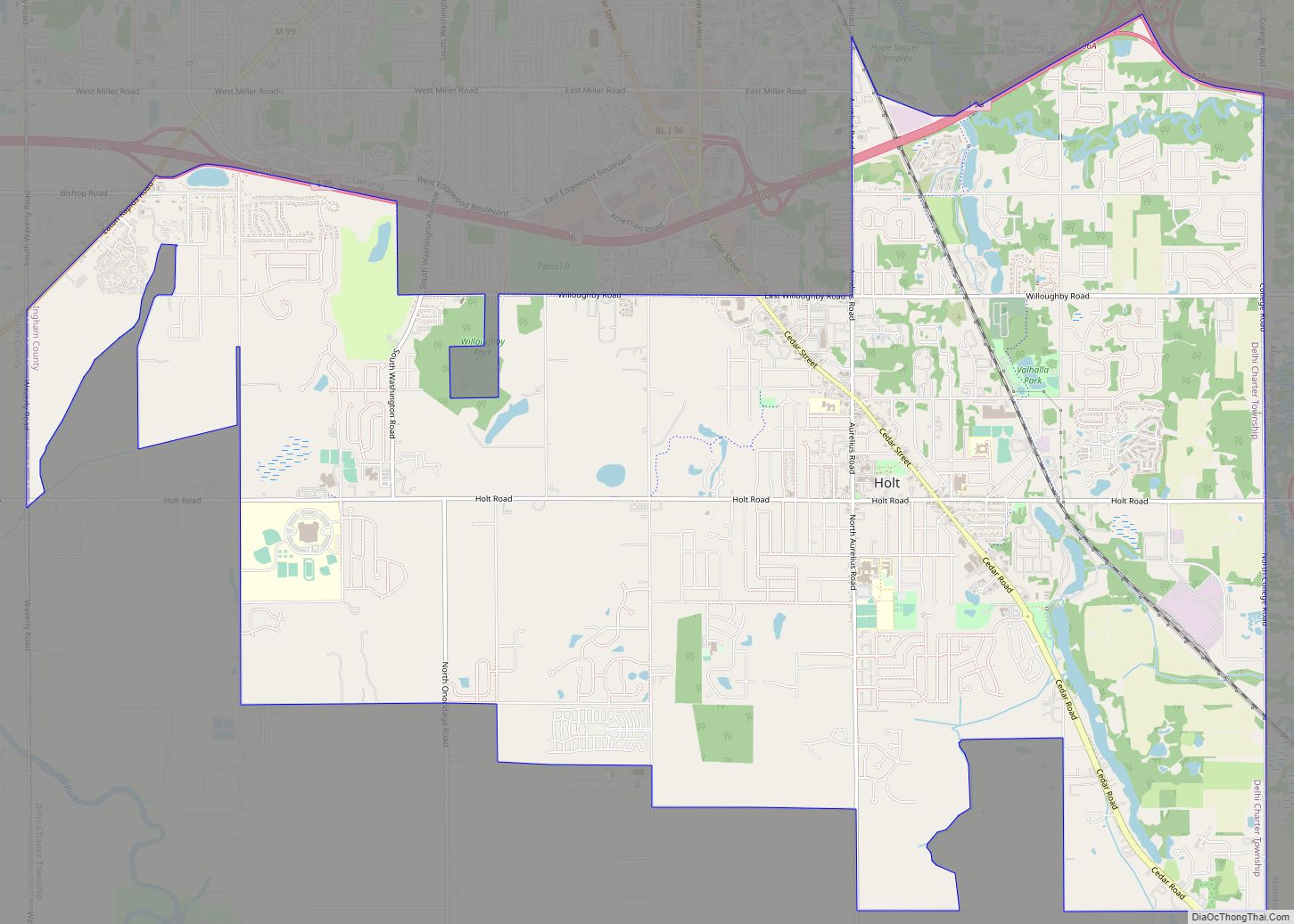
Holt is an unincorporated community and census-designated place (CDP) in Ingham County in the U.S. state of Michigan. The CDP is located within Delhi Charter Township and occupies a majority of the township. The population was 25,625 at the 2020 census, which is a significant increase from 11,315 at the 2000 census when the CDP … Read more

Map of Howard City village

Map of Howard City village, Michigan

Howard City is a village in Montcalm County in the U.S. state of Michigan. The population was 1,808 at the 2010 census. The village is within Reynolds Township. Howard City village overview: Name: Howard City village LSAD Code: 47 LSAD Description: village (suffix) State: Michigan County: Montcalm County Founded: 1868 Incorporated: 1873 (village) Elevation: 879 ft … Read more

Map of Houghton city, Michigan

Map of Houghton city, Michigan

Houghton (/ˈhoʊtən/; HO-tən) is the largest city and seat of government of Houghton County in the U.S. state of Michigan. Located on the Keweenaw Peninsula, Houghton is the largest city in the Copper Country region. It is the fifth-largest city in the Upper Peninsula, with a population of 8,386 at the 2020 census. Houghton is … Read more

Map of Houghton Lake CDP

Map of Houghton Lake CDP

Houghton Lake is an unincorporated community and census-designated place (CDP) in Roscommon County in the U.S. state of Michigan. The population was 5,294 at the time of the 2020 census, making it the largest unincorporated community in Northern Michigan. The CDP is located within Denton, Lake, and Roscommon townships. The community of Houghton Lake is … Read more

Map of Horton Bay CDP

Map of Horton Bay CDP

Horton Bay is an unincorporated community and census-designated place (CDP) in Charlevoix County in the U.S. state of Michigan. The population of the CDP was 485 at the 2020 census. The community is located within Bay Township on northeastern shores of Lake Charlevoix. Horton Bay CDP overview: Name: Horton Bay CDP LSAD Code: 57 LSAD … Read more

Map of Hopkins village

Map of Hopkins village, Michigan

Hopkins, formerly Hopkins Station, is a village within Hopkins Township in Allegan County in the U.S. state of Michigan. The population was 610 at the 2010 census. Hopkins village overview: Name: Hopkins village LSAD Code: 47 LSAD Description: village (suffix) State: Michigan County: Allegan County Elevation: 709 ft (216 m) Total Area: 0.48 sq mi (1.24 km²) Land Area: 0.48 sq mi … Read more

Map of Hudson city, Michigan

Map of Hudson city, Michigan

Hudson is a city in Lenawee County in the U.S. state of Michigan. The population was 2,307 at the 2010 census. The city is mostly surrounded by Hudson Township, but the two are administered autonomously. Hudson city overview: Name: Hudson city LSAD Code: 25 LSAD Description: city (suffix) State: Michigan County: Lenawee County Incorporated: 1893 … Read more

Map of Hubbell CDP

Map of Hubbell CDP, Michigan

Hubbell is an unincorporated community and census-designated place (CDP) in Houghton County in the U.S. state of Michigan. As of the 2010 census, the CDP population was 946, down from 1,105 at the 2000 census. The community is partially within Torch Lake Township and partially within Osceola Township. The community is on the west shore … Read more

Map of Hubbardston village

Map of Hubbardston village

Hubbardston is a village in the U.S. state of Michigan. It is mostly in North Plains Township in Ionia County, and partially in Lebanon Township in Clinton County. Its population was 395 at the 2010 census. Hubbardston village overview: Name: Hubbardston village LSAD Code: 47 LSAD Description: village (suffix) State: Michigan County: Clinton County, Ionia … Read more

Map of Hubbard Lake CDP

Map of Hubbard Lake CDP

Hubbard Lake is an unincorporated community and census-designated place (CDP) in Alcona County in the U.S. state of Michigan. The population was 857 at the 2020 census. Hubbard Lake occupies portions of Alcona, Caledonia, and Hawes township. The CDP surrounds Hubbard Lake and also includes the unincorporated communities of Backus Beach and Larson Beach. Hubbard … Read more