Map of Mackinac Island city

Map of Mackinac Island city

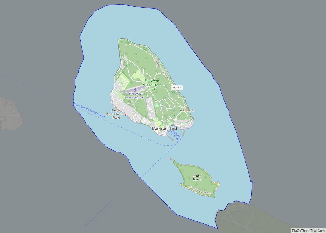
Mackinac Island (/ˈmækənɔː/ MAK-ə-naw, locally /ˈmækənə/ MAK-ə-nə) is a city in Mackinac County in the U.S. state of Michigan. As of the 2020 census, the city had a permanent population of 583. The population numbers in the tens of thousands from May 1st to October 31st due to an influx of visitors and hundreds of … Read more

Map of Lyons village, Michigan

Map of Lyons village, Michigan

Lyons is a village in Ionia County in the U.S. state of Michigan. The population was 789 at the 2010 census. Most of the village is within Lyons Township. A small portion extends west into Ionia Township. Lyons village overview: Name: Lyons village LSAD Code: 47 LSAD Description: village (suffix) State: Michigan County: Ionia County … Read more

Map of Luther village, Michigan

Map of Luther village, Michigan

Luther is a village in Lake County in the U.S. state of Michigan. The population was 318 at the 2010 census. The village is on the boundary between Newkirk Township on the west and Ellsworth Township on the east, with about half of the village in each. It is the site of Hillsdale College’s G.H. … Read more

Map of Lupton CDP, Michigan

Map of Lupton CDP, Michigan

Lupton is an unincorporated community and census-designated place (CDP) in Ogemaw County in the U.S. state of Michigan. At the 2010 census, it had a population of 348. Lupton is located mostly within Rose Township with a small portion extending south into Cumming Township. Lupton CDP overview: Name: Lupton CDP LSAD Code: 57 LSAD Description: … Read more

Map of Manistee city

Map of Manistee city

Manistee (/mænɪsti/ man-iss-TEE) is a city in the U.S. state of Michigan. Located in southwestern Manistee County, it is part of the northwestern Lower Peninsula. Manistee is the county seat of Manistee County, and its population was 6,259 at the 2020 census. This makes Manistee the fifth-largest city in Northern Michigan. Manistee is located on … Read more

Map of Manistee Lake CDP

Map of Manistee Lake CDP

Manistee Lake is an unincorporated community and census-designated place (CDP) in Kalkaska County in the U.S. state of Michigan. At the 2010 census, the CDP had a population of 456. Manistee Lake is located within Coldsprings Township to the north and a small portion extending south into Excelsior Township. Manistee Lake CDP overview: Name: Manistee … Read more

Map of Manchester village, Michigan

Map of Manchester village, Michigan

Manchester is a village in Manchester Township within Washtenaw County in the U.S. state of Michigan. The population was 2,037 at the 2020 census. Manchester village overview: Name: Manchester village LSAD Code: 47 LSAD Description: village (suffix) State: Michigan County: Washtenaw County Incorporated: 1867 Elevation: 899 ft (274 m) Total Area: 2.24 sq mi (5.81 km²) Land Area: 2.13 sq mi (5.51 km²) … Read more

Map of Mancelona village

Map of Mancelona village

Mancelona (/mænˌsəˈloʊnə/ man-sə-LOW-nə) is a village in the Northern Lower Peninsula of the U.S. state of Michigan. Part of Mancelona Township, the village is located within Antrim County. Its population was 1,344 at the 2020 census. Mancelona village overview: Name: Mancelona village LSAD Code: 47 LSAD Description: village (suffix) State: Michigan County: Antrim County Incorporated: … Read more

Map of Madison Heights city

Map of Madison Heights city, Michigan

Madison Heights is a city in Oakland County in the U.S. state of Michigan. As of the 2010 census, its population was 29,694. It is a northern suburb of Metro Detroit, about 2 miles (3.2 km) north of the Detroit city limits. Madison Heights city overview: Name: Madison Heights city LSAD Code: 25 LSAD Description: city … Read more

Map of Manitou Beach-Devils Lake CDP

Map of Manitou Beach-Devils Lake CDP

Manitou Beach-Devils Lake CDP overview: Name: Manitou Beach-Devils Lake CDP LSAD Code: 57 LSAD Description: CDP (suffix) State: Michigan County: Lenawee County FIPS code: 2650830 Online Interactive Map Manitou Beach-Devils Lake online map. Source: Basemap layers from Google Map, Open Street Map (OSM), Arcgisonline, Wmflabs. Boundary Data from Database of Global Administrative Areas. Manitou Beach-Devils … Read more

Map of Manistique city

Map of Manistique city

Manistique (/mænɪstik/ man-iss-TEEK) is the only city and county seat of Schoolcraft County in the U.S. state of Michigan. As of the 2020 census, the city population was 2,828. The city borders the adjacent Manistique Township, but the two are administered independently. The city lies on the north shore of Lake Michigan at the mouth … Read more

Map of Maple Grove CDP

Map of Maple Grove CDP, Michigan

Maple Grove is an unincorporated community and census-designated place in Benzie County in the U.S. state of Michigan. The population was 132 at the 2010 census. Maple Grove is located within Almira Township. Maple Grove CDP overview: Name: Maple Grove CDP LSAD Code: 57 LSAD Description: CDP (suffix) State: Michigan County: Benzie County Elevation: 820 ft … Read more