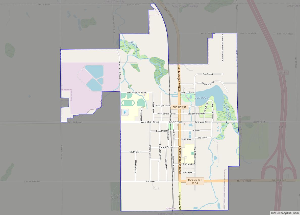
Map of Manitou Beach-Devils Lake CDP

Map of Manitou Beach-Devils Lake CDP

Manitou Beach-Devils Lake CDP overview: Name: Manitou Beach-Devils Lake CDP LSAD Code: 57 LSAD Description: CDP (suffix) State: Michigan County: Lenawee County FIPS code: 2650830 Online Interactive Map Manitou Beach-Devils Lake online map. Source: Basemap layers from Google Map, Open Street Map (OSM), Arcgisonline, Wmflabs. Boundary Data from Database of Global Administrative Areas. Manitou Beach-Devils … Read more

Map of Manistique city

Map of Manistique city

Manistique (/mænɪstik/ man-iss-TEEK) is the only city and county seat of Schoolcraft County in the U.S. state of Michigan. As of the 2020 census, the city population was 2,828. The city borders the adjacent Manistique Township, but the two are administered independently. The city lies on the north shore of Lake Michigan at the mouth … Read more

Map of Maple Rapids village

Map of Maple Rapids village

Maple Rapids is a village in Clinton County in the U.S. state of Michigan. The population was 672 at the 2010 census. The village is located in Essex Township about 10 miles (16.1 km) northwest of St. Johns. A portion of the village is within the Maple River State Game Area. Maple Rapids village overview: Name: … Read more

Map of Marion village, Michigan

Map of Marion village, Michigan

Marion is a village in Osceola County in the U.S. state of Michigan. The population was 872 at the 2010 census. The village is located within Marion Township. Marion village overview: Name: Marion village LSAD Code: 47 LSAD Description: village (suffix) State: Michigan County: Osceola County Elevation: 1,099 ft (335 m) Total Area: 1.33 sq mi (3.44 km²) Land Area: … Read more

Map of Marine City city

Map of Marine City

Marine City is a city in St. Clair County in the U.S. state of Michigan. Located on the west bank of the St. Clair River, it is one of the cities in the River District north of Detroit and south of Lake Huron. In the late 19th century, it was a major center of wooden … Read more

Map of Marenisco CDP

Map of Marenisco CDP

Marenisco is an unincorporated community and census-designated place (CDP) in Marenisco Township, Gogebic County, Michigan, in the United States. As of the 2010 census, the CDP had a population of 254, out of a total population in the township of 1,727. The name of the community and the township was formed by combining the first … Read more

Map of Marcellus village

Map of Marcellus village, Michigan

Marcellus is a village in Cass County in the U.S. state of Michigan. The population was 1,198 at the 2010 census. The village is located within Marcellus Township. It is part of the South Bend–Mishawaka, IN-MI, Metropolitan Statistical Area. Marcellus village overview: Name: Marcellus village LSAD Code: 47 LSAD Description: village (suffix) State: Michigan County: … Read more

Map of Marysville city, Michigan

Map of Marysville city, Michigan

Marysville is a city in St. Clair County of the U.S. state of Michigan. The population was 9,959 at the 2010 census. The municipality was founded in 1919, first as a village, then became a city in 1924. Marysville is located on the western shore of the St. Clair River, across from Corunna, Ontario. The … Read more

Map of Martin village, Michigan

Map of Martin village, Michigan

Martin is a village in southeastern Allegan County in the U.S. state of Michigan. The population was 410 at the 2010 census. Martin village overview: Name: Martin village LSAD Code: 47 LSAD Description: village (suffix) State: Michigan County: Allegan County Elevation: 830 ft (253 m) Total Area: 0.77 sq mi (1.98 km²) Land Area: 0.77 sq mi (1.98 km²) Water Area: 0.00 sq mi (0.00 km²) … Read more

Map of Marshall city, Michigan

Map of Marshall city, Michigan

Marshall is a U.S. city in Michigan. It is the county seat of Calhoun County. The population was 6,822 at the 2020 census. Marshall is best known for its cross-section of 19th- and early 20th-century architecture. It has been referred to by the keeper of the National Register of Historic Places as a “virtual textbook … Read more

Map of Marquette city, Michigan

Map of Marquette city, Michigan

Marquette (/mɑːrˈkɛt/ mar-KEHT) is the largest city in the Upper Peninsula of the U.S. state of Michigan. Marquette is the county seat of Marquette County. Located on the shores of Lake Superior, Marquette is a major port, known primarily for shipping iron ore from the Marquette Iron Range. The city is partially surrounded by Marquette … Read more

Map of Marlette city

Map of Marlette city

Marlette is a city in Sanilac County in the U.S. state of Michigan. The population was 1,855 at the time of the 2020 census. The city is surrounded by Marlette Township, but is administratively autonomous. Marlette is known as “The Heart of the Thumb” due to its location in Michigan’s thumb. Marlette city overview: Name: … Read more