Map of New Baltimore city

Map of New Baltimore city, Michigan

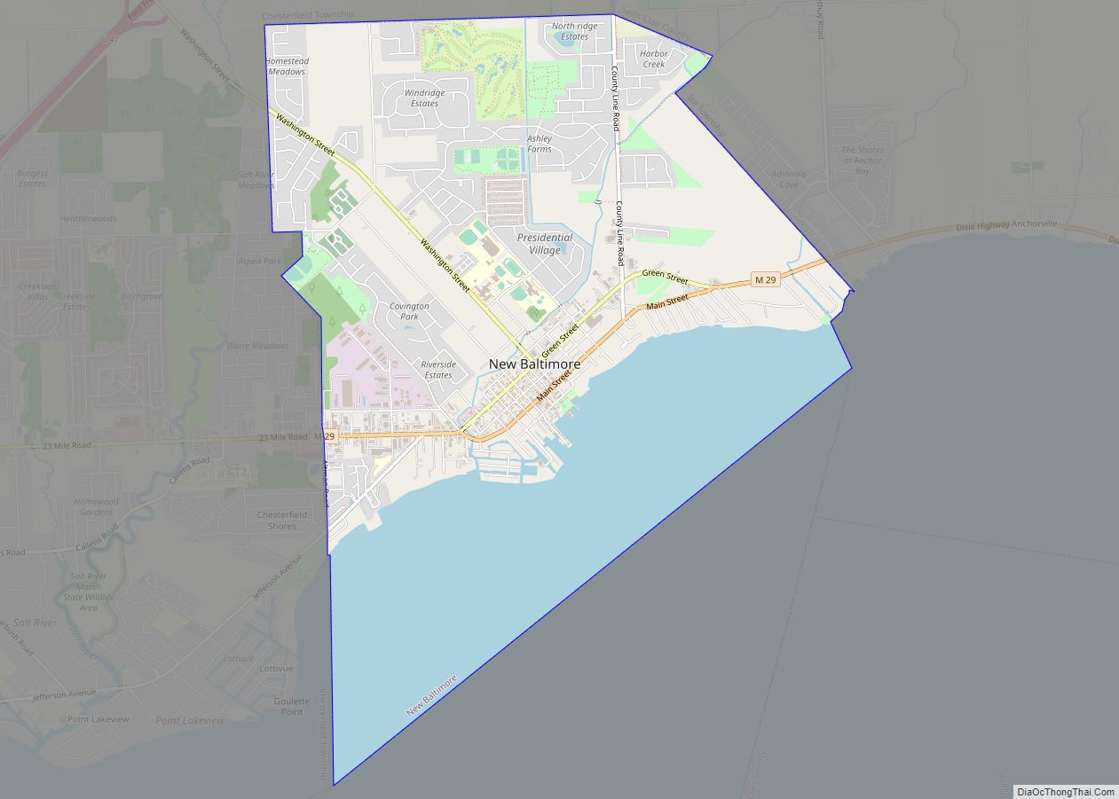
New Baltimore is a city in Macomb County in the U.S. state of Michigan. The population was 12,117 at the 2020 census. New Baltimore is a northern suburb of Metro Detroit and is located along the northern shores of Lake St. Clair. New Baltimore city overview: Name: New Baltimore city LSAD Code: 25 LSAD Description: … Read more

Map of Nessen City CDP

Map of Nessen City CDP

Nessen City is an unincorporated community and census-designated place in Benzie County in the U.S. state of Michigan. The population was 97 at the 2010 census. Nessen City is located within Colfax Township. Nessen City CDP overview: Name: Nessen City CDP LSAD Code: 57 LSAD Description: CDP (suffix) State: Michigan County: Benzie County Elevation: 856 ft … Read more

Map of New Troy CDP

Map of New Troy CDP

New Troy is an unincorporated community and census-designated place in Berrien County in the U.S. state of Michigan. The population was 483 at the 2020 census. New Troy CDP overview: Name: New Troy CDP LSAD Code: 57 LSAD Description: CDP (suffix) State: Michigan County: Berrien County Elevation: 646 ft (197 m) Total Area: 1.33 sq mi (3.44 km²) Land Area: … Read more

Map of New Lothrop village

Map of New Lothrop village

New Lothrop is a village in Shiawassee County in the U.S. state of Michigan. The population was 581 at the 2010 census. The village is located within Hazelton Township. New Lothrop village overview: Name: New Lothrop village LSAD Code: 47 LSAD Description: village (suffix) State: Michigan County: Shiawassee County Incorporated: 1947 Elevation: 696 ft (212 m) Total … Read more

Map of Niles city, Michigan

Map of Niles city, Michigan

Niles is a city in Berrien and Cass counties in the U.S. state of Michigan, near the Indiana state line city of South Bend. In 2010, the population was 11,600 according to the 2010 census. It is the larger, by population, of the two principal cities in the Niles-Benton Harbor Metropolitan Statistical Area, an area … Read more

Map of Newberry village, Michigan

Map of Newberry village, Michigan

Newberry (/nuːbɛri/ NU-bair-ee) is a village and county seat of Luce County in the U.S. state of Michigan. The village is located within McMillan Township and is the only incorporated community in Luce County. The population was 1,446 at the 2020 census. Newberry is surrounded by state and national forests and is considered the southern … Read more

Map of Newaygo city

Map of Newaygo city

Newaygo (/nəweɪɡoʊ/ nə-WAY-goh) is a rural city in Newaygo County in the U.S. state of Michigan. The population was 2,471 at the 2020 census. Newaygo city overview: Name: Newaygo city LSAD Code: 25 LSAD Description: city (suffix) State: Michigan County: Newaygo County Elevation: 692 ft (211 m) Total Area: 3.92 sq mi (10.16 km²) Land Area: 3.77 sq mi (9.75 km²) Water Area: … Read more

Map of Northview CDP

Map of Northview CDP

Northview is an unincorporated community and census-designated place (CDP) in Kent County in the U.S. state of Michigan. The population was 14,541 at the 2010 census. The community is located mostly within Plainfield Township with a very small portion extending into Grand Rapids Township to the south. The community is part of the Grand Rapids … Read more

Map of Northport village, Michigan

Map of Northport village, Michigan

Northport is a village in Leelanau County in the U.S. state of Michigan. Located near the northern tip of the Leelanau Peninsula, Northport is located within Leelanau Township, and lies on the shore of Grand Traverse Bay, a bay of Lake Michigan. Northport had a population of 496 at the 2020 census. The village is … Read more

Map of North Muskegon city

Map of North Muskegon city

North Muskegon is a city in Muskegon County in the U.S. state of Michigan. The population was 3,786 at the 2010 census. North Muskegon city overview: Name: North Muskegon city LSAD Code: 25 LSAD Description: city (suffix) State: Michigan County: Muskegon County Elevation: 620 ft (189 m) Total Area: 4.12 sq mi (10.67 km²) Land Area: 1.79 sq mi (4.63 km²) Water Area: … Read more

Map of North Branch village

Map of North Branch village, Michigan

North Branch is a village in Lapeer County in the U.S. state of Michigan. The population was 1,033 at the 2010 census. The village is located within North Branch Township. North Branch village overview: Name: North Branch village LSAD Code: 47 LSAD Description: village (suffix) State: Michigan County: Lapeer County Elevation: 814 ft (248 m) Total Area: … Read more

Map of North Adams village, Michigan

Map of North Adams village, Michigan

North Adams is a village in Hillsdale County in the U.S. state of Michigan. The population was 452 at the 2020 census. The village is located within Adams Township. North Adams village overview: Name: North Adams village LSAD Code: 47 LSAD Description: village (suffix) State: Michigan County: Hillsdale County Incorporated: 1881 Elevation: 1,191 ft (363 m) Total … Read more