Map of Springfield city, Michigan

Map of Springfield city, Michigan

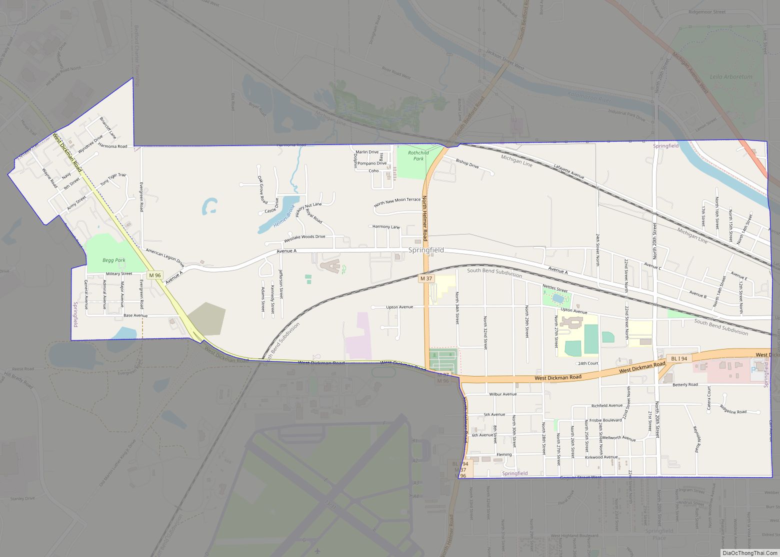
Springfield is a city in Calhoun County in the U.S. state of Michigan. It is an enclave of the city of Battle Creek. The population was 5,260 at the 2010 census. Springfield city overview: Name: Springfield city LSAD Code: 25 LSAD Description: city (suffix) State: Michigan County: Calhoun County Elevation: 879 ft (268 m) Total Area: 3.70 sq mi … Read more

Map of Spring Lake village, Michigan

Map of Spring Lake village, Michigan

Spring Lake is a village in Ottawa County in the U.S. state of Michigan. The population was 2,323 at the 2010 census. The village is located within Spring Lake Township. Spring Lake village overview: Name: Spring Lake village LSAD Code: 47 LSAD Description: village (suffix) State: Michigan County: Ottawa County Elevation: 597 ft (182 m) Total Area: … Read more

Map of Spring Arbor CDP

Map of Spring Arbor CDP

Spring Arbor is an unincorporated community and census-designated place (CDP) in Jackson County in the U.S. state of Michigan. The population of the CDP was 2,881 at the 2010 census, up from 2,188 at the 2000 census. The CDP is located within Spring Arbor Township. Spring Arbor is the home of Spring Arbor University, a … Read more

Map of Sparta village, Michigan

Map of Sparta village, Michigan

Sparta is a village in Kent County in the U.S. state of Michigan. The population was 4,244 at the 2020 census. The village is located within Sparta Township. Sparta is part of the Grand Rapids metropolitan area and is located about 10 miles (16 km) north of the city of Grand Rapids. Sparta village overview: Name: … Read more

Map of Southgate city, Michigan

Map of Southgate city, Michigan

Southgate is a city in Wayne County in the U.S. state of Michigan. The population was 30,047 at the 2020 census. Southgate was incorporated as a city in October 1958, which was one of the last remaining portions of the now-defunct Ecorse Township. It is part of the Downriver collection of communities south of the … Read more

Map of St. Clair Shores city

Map of St. Clair Shores city

St. Clair Shores is a suburban city bordering Lake St. Clair in Macomb County of the U.S. state of Michigan. It forms a part of the Metro Detroit area, and is located about 13 miles (21 km) northeast of downtown Detroit. Its population was 59,715 at the 2010 census. St. Clair Shores city overview: Name: St. … Read more

Map of St. Charles village, Michigan

Map of St. Charles village, Michigan

St. Charles is a village in Saginaw County in the U.S. state of Michigan. The village is located in the northwest corner of St. Charles Township with portions of the village located within Brant and Swan Creek townships. The population was 2,054 at the 2010 census. St. Charles village overview: Name: St. Charles village LSAD … Read more

Map of Springport village, Michigan

Map of Springport village, Michigan

Springport is a village in Jackson County of the U.S. state of Michigan. The population was 800 at the 2010 census. The village is located within Springport Township on M-99 about 20 miles (32.2 km) northwest of Jackson. Springport High School is located in the village. Springport village overview: Name: Springport village LSAD Code: 47 LSAD … Read more

Map of St. Helen CDP

Map of St. Helen CDP

St. Helen is an unincorporated community and census-designated place (CDP) in Roscommon County in the U.S. state of Michigan. The population was 2,735 at the 2020 census. St. Helen is located within Richfield Township. St. Helen CDP overview: Name: St. Helen CDP LSAD Code: 57 LSAD Description: CDP (suffix) State: Michigan County: Roscommon County Elevation: … Read more

Map of St. Clair city

Map of St. Clair city, Michigan

St. Clair is a city in St. Clair County in the eastern “Thumb” of the U.S. state of Michigan. The population was 5,485 at the 2010 census. The city is located on the St. Clair River near the southeast corner of St. Clair Township. St. Clair city overview: Name: St. Clair city LSAD Code: 25 … Read more

Map of St. Louis city

Map of St. Louis city, Michigan

St. Louis is a city in Gratiot County in the U.S. state of Michigan. As of the 2010 census the population was 7,482. St. Louis city overview: Name: St. Louis city LSAD Code: 25 LSAD Description: city (suffix) State: Michigan County: Gratiot County Elevation: 732 ft (223 m) Total Area: 3.50 sq mi (9.06 km²) Land Area: 3.31 sq mi (8.59 km²) Water … Read more

Map of St. Joseph city, Michigan

Map of St. Joseph city, Michigan

St. Joseph, colloquially known as St. Joe, is a city and the county seat of Berrien County, Michigan. It was incorporated as a village in 1834 and as a city in 1891. As of the 2010 census, the city population was 8,365. It lies on the shore of Lake Michigan, at the mouth of the … Read more