Map of Trenton city, Michigan

Map of Trenton city, Michigan

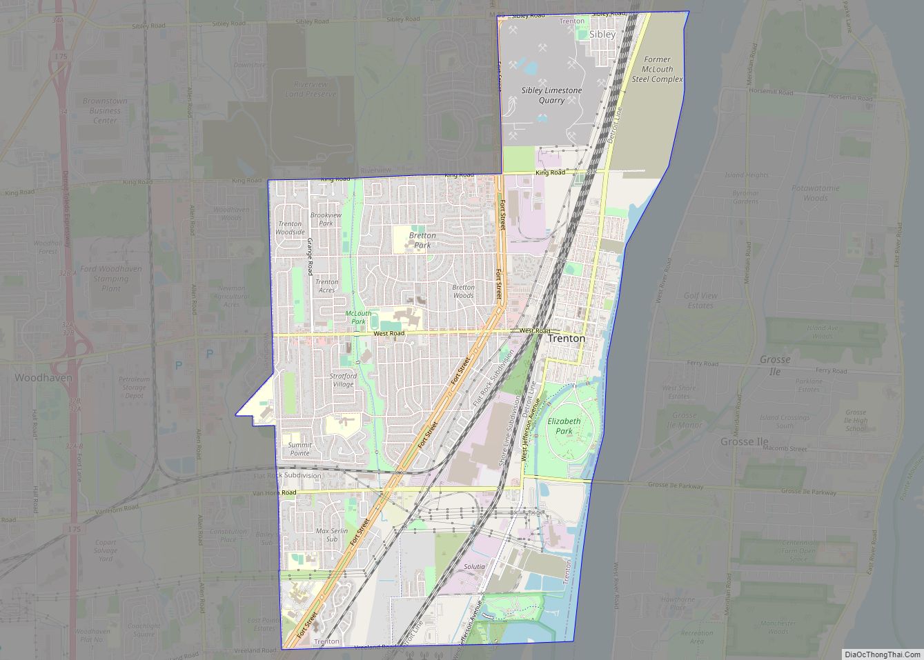
Trenton is a city in Wayne County, Michigan, United States. At the 2010 census, the city population was 18,853. A Shawnee village was built in the area by war chief Blue Jacket after the 1795 Treaty of Greenville. The area later became the site of the Battle of Monguagon between Americans and a British-Indian coalition … Read more

Map of Traverse City city

Map of Traverse City

Traverse City (/ˈtrævərz/ TRAV-ərz) is a city in the U.S. state of Michigan. It is the county seat of Grand Traverse County, although a small portion extends into Leelanau County. It is the largest city in the 21-county Northern Michigan region. The population was 15,678 at the 2020 census, with 153,448 in the four-county Traverse … Read more

Map of Three Rivers city, Michigan

Map of Three Rivers city, Michigan

Three Rivers is a city in St. Joseph County, Michigan. The population was 7,973 at the time of the 2020 census. Three Rivers derives its name from its location at the confluence of the St. Joseph River and two tributaries, the Rocky and Portage rivers. The St. Joseph River flows into Lake Michigan. The city … Read more

Map of Three Oaks village, Michigan

Map of Three Oaks village, Michigan

Three Oaks is a village in Three Oaks Township, Berrien County in the U.S. state of Michigan. The population was 1,622 at the 2010 census. The village of Three Oaks is located in the southwest corner of Michigan, just 5 miles from the shores of Lake Michigan and within 2 miles of the Indiana border … Read more

Map of Twining village

Map of Twining village

Twining is a village in Arenac County of the U.S. state of Michigan. The population was 181 at the 2010 census. The village is situated on the boundary between Mason Township on the west and Turner Township on the east, with about half of the village in each. Twining village overview: Name: Twining village LSAD … Read more

Map of Twin Lake CDP

Map of Twin Lake CDP

Twin Lake is an unincorporated community in Muskegon County of the U.S. state of Michigan. It is a census-designated place (CDP) for statistical purposes. Local government services are provided by Dalton Township. As of the 2000 census, the community population was 1,613. It is the home of Blue Lake Fine Arts Camp, the YMCA’s Camp … Read more

Map of Tustin village, Michigan

Map of Tustin village, Michigan

Tustin is a village in Osceola County of the U.S. state of Michigan. The population was 230 at the 2010 census. The village is within Burdell Township. Tustin village overview: Name: Tustin village LSAD Code: 47 LSAD Description: village (suffix) State: Michigan County: Osceola County Elevation: 1,227 ft (374 m) Total Area: 0.39 sq mi (1.00 km²) Land Area: 0.39 sq mi … Read more

Map of Turner village

Map of Turner village, Michigan

Turner is a village in Arenac County of the U.S. state of Michigan. The population was 114 at the 2010 census, which ranks Turner as the least-populated village in the state. The village is located within Turner Township. Turner village overview: Name: Turner village LSAD Code: 47 LSAD Description: village (suffix) State: Michigan County: Arenac … Read more

Map of Troy city, Michigan

Map of Troy city, Michigan

Troy is a city in Oakland County, Michigan, United States. Its population was 87,294 at the 2020 U.S. census, making Troy the most populous city in the county and the 13th most-populous municipality in the state. Troy is a northern suburb of Metro Detroit, located about sixteen miles (26 km) northwest of downtown Detroit. Troy was … Read more

Map of Unionville village, Michigan

Map of Unionville village, Michigan

Unionville is a village in Tuscola County in the U.S. state of Michigan. The population was 508 at the 2010 census. The village is located in the northwestern corner of Columbia Township. Unionville village overview: Name: Unionville village LSAD Code: 47 LSAD Description: village (suffix) State: Michigan County: Tuscola County Elevation: 620 ft (189 m) Total Area: … Read more

Map of Union City village, Michigan

Map of Union City village, Michigan

Union City is a village in Branch and Calhoun counties in the U.S. state of Michigan. Located mostly within Union Township in Branch County, it sits at the junction of the Coldwater and St. Joseph rivers; the Calhoun County portion lies within that county’s Burlington Township. It is part of the Battle Creek, Michigan Metropolitan … Read more

Map of Ubly village

Map of Ubly village

Ubly is a village in Huron County in the U.S. state of Michigan. The population was 858 at the 2010 census. The village is within Bingham Township. On February 25, 2004, a wolverine was spotted near Ubly, the first one sighted in Michigan in over 200 years. Ubly village overview: Name: Ubly village LSAD Code: … Read more