Map of Berrien Springs village

Map of Berrien Springs village

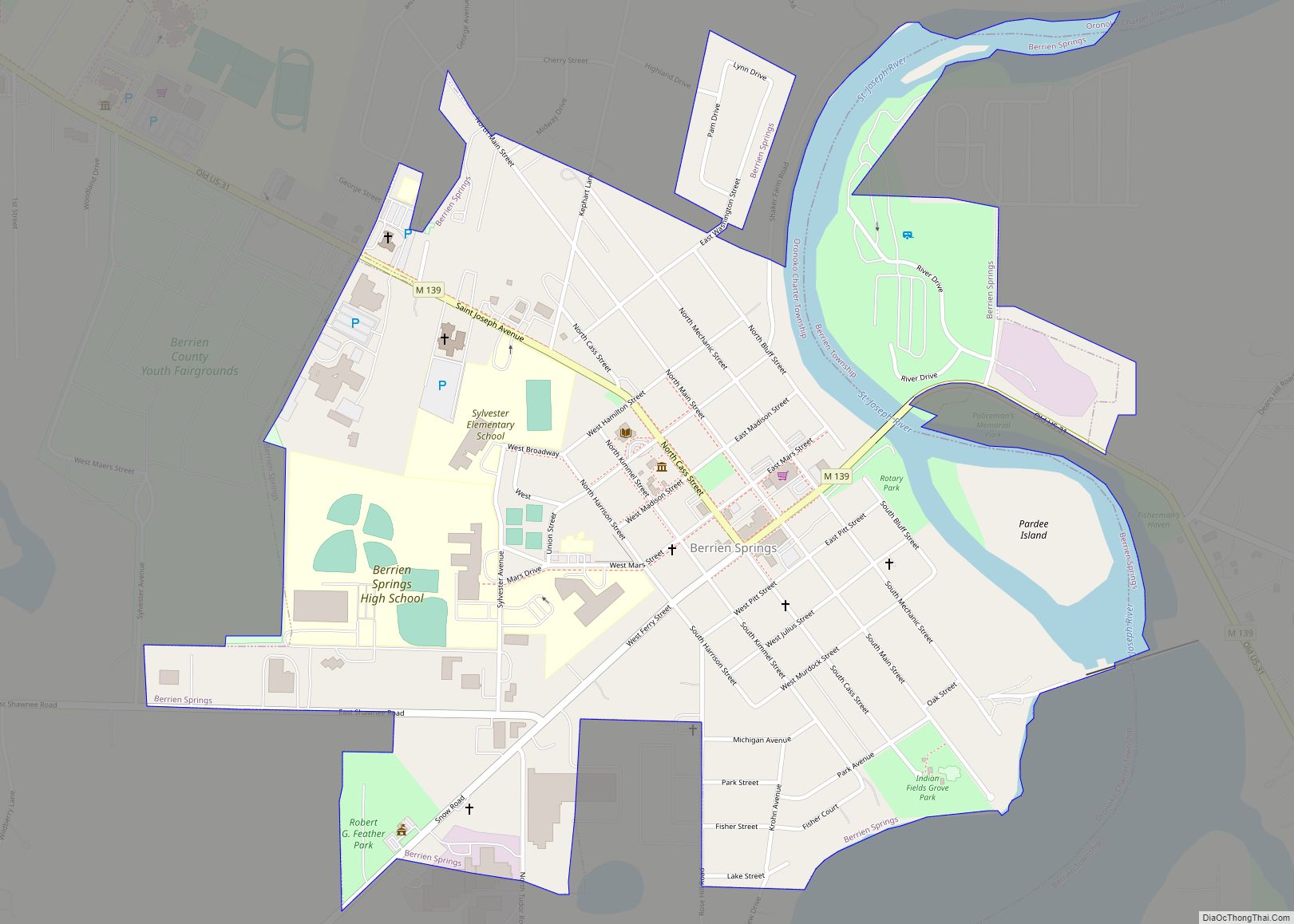
Berrien Springs is a village in Berrien County in the U.S. state of Michigan. The population was 1,800 at the time of the 2010 census. The village is located within Oronoko Charter Township. Berrien Springs village overview: Name: Berrien Springs village LSAD Code: 47 LSAD Description: village (suffix) State: Michigan County: Berrien County Elevation: 673 ft … Read more

Map of Birmingham city, Michigan

Map of Birmingham city, Michigan

Birmingham is a city in Oakland County in the U.S. state of Michigan. It is a northern suburb of Detroit located along the Woodward Corridor (M-1). As of the 2010 census, the population was 20,103. Birmingham city overview: Name: Birmingham city LSAD Code: 25 LSAD Description: city (suffix) State: Michigan County: Oakland County Incorporated: 1864 … Read more

Map of Birch Run village

Map of Birch Run village

Birch Run is a village in Saginaw County in the U.S. state of Michigan. The population was 1,553 at the 2010 census. The village is located within Birch Run Township. Birch Run village overview: Name: Birch Run village LSAD Code: 47 LSAD Description: village (suffix) State: Michigan County: Saginaw County Founded: 1852 Incorporated: 1955 Elevation: … Read more

Map of Bingham Farms village

Map of Bingham Farms village

Bingham Farms is a village in Oakland County in the U.S. state of Michigan. As of the 2020 census, the population was 1,124. The village is located within Southfield Township. Bingham Farms village overview: Name: Bingham Farms village LSAD Code: 47 LSAD Description: village (suffix) State: Michigan County: Oakland County Incorporated: 1955 Elevation: 712 ft (217 m) … Read more

Map of Big Rapids city

Map of Big Rapids city

Big Rapids is a city and the county seat of Mecosta County, Michigan The population was 10,601 at the 2010 census. . The city is located within Big Rapids Township, but it is politically independent. Big Rapids is home of the main campus of Ferris State University, a four-year public university, well known for its … Read more

Map of Blissfield village

Map of Blissfield village

Blissfield is a village in Lenawee County in the U.S. state of Michigan. The population was 3,340 at the 2010 census. The village is mostly located within Blissfield Township with only very small portions extending west into Palmyra Township and south into Riga Township. The Blissfield post office first opened March 28, 1828. Hervey Bliss, … Read more

Map of Boyne Falls village

Map of Boyne Falls village

Boyne Falls is a village in Charlevoix County in the U.S. state of Michigan. The population was 358 at the 2020 census. The village is located within Boyne Valley Township. Boyne Falls village overview: Name: Boyne Falls village LSAD Code: 47 LSAD Description: village (suffix) State: Michigan County: Charlevoix County Incorporated: 1893 Elevation: 722 ft (220 m) … Read more

Map of Boyne City city

Map of Boyne City

Boyne City (/bɔɪn/) is a city in Charlevoix County in the U.S. state of Michigan. The population was 3,816 at the 2020 census, making it the largest city in Charlevoix County. Boyne City is located at the eastern end of Lake Charlevoix, Michigan’s third largest inland lake. The city is also the site of the … Read more

Map of Boon CDP

Map of Boon CDP

Boon is an unincorporated community and census-designated place (CDP) in Wexford County in the U.S. state of Michigan. The community is located within Boon Township. The population of the CDP was 90 at the 2020 census. As an unincorporated community, Boon has no legal autonomy of its own but does have its own post office … Read more

Map of Bloomingdale village, Michigan

Map of Bloomingdale village, Michigan

Bloomingdale is a village in Van Buren County in the U.S. state of Michigan. The population was 454 at the 2010 census. The village is located within Bloomingdale Township and is the township seat. In the 1930s oil was discovered within the village limits, but pumping has now ceased due to lack of oil. Bloomingdale … Read more

Map of Bloomfield Hills city

Map of Bloomfield Hills city

Bloomfield Hills is a small city (5.04 sq. miles) in Oakland County in the U.S. state of Michigan. It is a northern suburb of Metro Detroit and is approximately 20 miles (32 km) northwest of Downtown Detroit. Except for a small southern border with the city of Birmingham, the city is almost completely surrounded by Bloomfield … Read more

Map of Bridgman city

Map of Bridgman city

Bridgman is a city in Berrien County in the U.S. state of Michigan. The population was 2,291 at the time of the 2010 census. Bridgman city overview: Name: Bridgman city LSAD Code: 25 LSAD Description: city (suffix) State: Michigan County: Berrien County Elevation: 679 ft (207 m) Total Area: 2.92 sq mi (7.57 km²) Land Area: 2.89 sq mi (7.49 km²) Water Area: … Read more