Map of Iron Junction city
Iron Junction is a city in Saint Louis County, Minnesota, United States. The population was 86 at the 2010 census. Saint Louis County Highway 7 and Iron Junction Road serve as main routes in the community. State Highway 37 (MN 37) is nearby. The name Iron Junction, as a place of residence, is seldom used ... Read more
Map of Iron Junction city
Map of Iona city, Minnesota
Iona is a city in Murray County, Minnesota, United States. The population was 137 at the 2010 census. Iona city overview: Name: Iona city LSAD Code: 25 LSAD Description: city (suffix) State: Minnesota County: Murray County Elevation: 1,631 ft (497 m) Total Area: 0.78 sq mi (2.01 km²) Land Area: 0.78 sq mi (2.01 km²) Water Area: 0.00 sq mi (0.00 km²) Total Population: 166 Population ... Read more
Map of Iona city, Minnesota
Map of Inver Grove Heights city
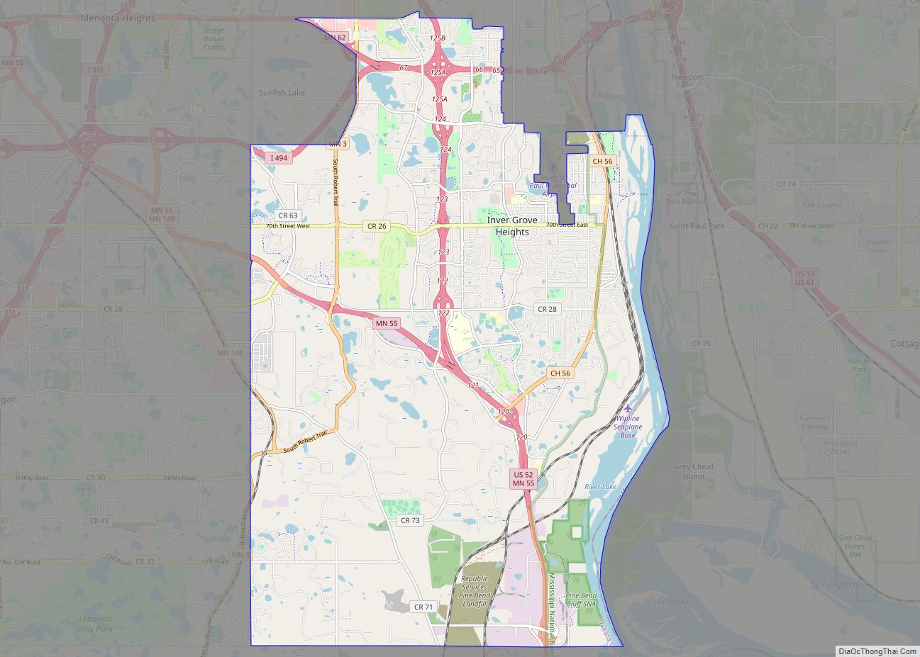
Inver Grove Heights is a city in Dakota County, Minnesota, United States. The population was 35,801 at the 2020 census. The city was formed on March 9, 1965, with the merger of the village of Inver Grove and Inver Grove Township. It is one of 186 cities and townships in the seven-county Minneapolis-Saint Paul metropolitan ... Read more
Map of Inver Grove Heights city
Map of International Falls city
International Falls (sometimes referred to as I-Falls) is a city in and the county seat of Koochiching County, Minnesota. The population was 5,802 at the time of the 2020 census. International Falls is located on the Rainy River directly across from Fort Frances, Ontario, Canada. The two cities are connected by the Fort Frances–International Falls ... Read more
Map of International Falls city
Map of Inger CDP
Inger is an unincorporated community and census-designated place (CDP) in Itasca County, Minnesota, United States, along the Bowstring River of the Leech Lake Indian Reservation. As of the 2010 census, its population was 212. The center of Inger is generally considered as being at the junction of Itasca County Roads 35 and 146. State Highway ... Read more
Map of Inger CDP
Map of Independence city, Minnesota
Independence is a rural city in Hennepin County, Minnesota, United States. Most of the city is agricultural land with dense woods and numerous lakes. It is named after Lake Independence, a large lake on the community’s eastern boundary. The population was 3,504 at the 2010 census. U.S. Highway 12 serves as a main route in ... Read more
Map of Independence city, Minnesota
Map of Ihlen city
Ihlen (/ˈiːlən/ EE-lən) is a city in Pipestone County, Minnesota, United States. The population was 61 at the 2020 census. Ihlen city overview: Name: Ihlen city LSAD Code: 25 LSAD Description: city (suffix) State: Minnesota County: Pipestone County Elevation: 1,634 ft (498 m) Total Area: 0.38 sq mi (0.98 km²) Land Area: 0.37 sq mi (0.97 km²) Water Area: 0.00 sq mi (0.01 km²) Total Population: ... Read more
Map of Ihlen city
Map of Jenkins city, Minnesota
Jenkins is a city in Crow Wing County, Minnesota, United States. The population was 430 at the 2010 census. It is part of the Brainerd Micropolitan Statistical Area. Jenkins city overview: Name: Jenkins city LSAD Code: 25 LSAD Description: city (suffix) State: Minnesota County: Crow Wing County Elevation: 1,266 ft (386 m) Total Area: 4.50 sq mi (11.66 km²) Land ... Read more
Map of Jenkins city, Minnesota
Map of Jeffers city
Jeffers is a city in Amboy Township, Cottonwood County, Minnesota, United States. The population was 369 at the 2010 census. Minnesota State Highway 30 and County Highway 4 are two of the main routes in the community. U.S. Route 71 is nearby. Jeffers city overview: Name: Jeffers city LSAD Code: 25 LSAD Description: city (suffix) ... Read more
Map of Jeffers city
Map of Jasper city, Minnesota
Jasper is a city in Pipestone and Rock counties in the State of Minnesota. The population was 633 at the 2010 census. Most of the city lies in Pipestone County, with only a small part of the city extending into Rock County. Jasper city overview: Name: Jasper city LSAD Code: 25 LSAD Description: city (suffix) ... Read more
Map of Jasper city, Minnesota
Map of Janesville city, Minnesota
Janesville is a city in Waseca County, Minnesota, United States. The population was 2,256 at the 2010 census. U.S. Highway 14 serves as a main route in the community, running east–west, south of Janesville. County Road 3 runs north–south through the town. There is one disabled stoplight, now a four way stop, in Janesville at ... Read more
Map of Janesville city, Minnesota
Map of Jackson city, Minnesota
Jackson is a city and county seat of Jackson County, Minnesota, United States. The population was 3,299 at the 2010 census. Jackson city overview: Name: Jackson city LSAD Code: 25 LSAD Description: city (suffix) State: Minnesota County: Jackson County Elevation: 1,316 ft (401 m) Total Area: 5.22 sq mi (13.53 km²) Land Area: 5.19 sq mi (13.45 km²) Water Area: 0.03 sq mi (0.08 km²) Total ... Read more
Map of Jackson city, Minnesota