Map of Okolona city, Mississippi

Map of Okolona city, Mississippi

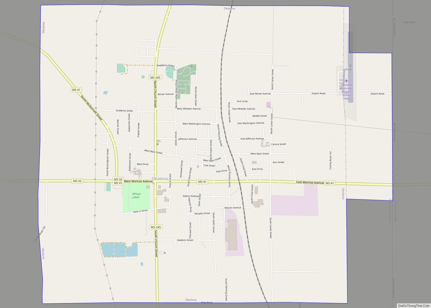
Okolona is a city in and one of the two county seats of Chickasaw County, Mississippi, United States. It is located near the eastern border of the county. The population was 2,692 at the 2010 census. It had a large furniture industry and the Wilson Park resort. Okolona city overview: Name: Okolona city LSAD Code: … Read more

Map of Pearl River CDP, Mississippi

Map of Pearl River CDP, Mississippi

Pearl River is a census-designated place (CDP) in Neshoba County, Mississippi. It is one of the eight communities of the Mississippi Band of Choctaw Indians Reservation and the population is 80% Choctaw. The population was 3,156 at the 2000 census. Pearl River CDP overview: Name: Pearl River CDP LSAD Code: 57 LSAD Description: CDP (suffix) … Read more

Map of Pass Christian city

Map of Pass Christian city

Pass Christian (/ˌpæs krɪstʃiˈæn/), nicknamed The Pass, is a city in Harrison County, Mississippi, United States. It is part of the Gulfport–Biloxi Metropolitan Statistical Area. The population was 6,307 at the 2019 census. Pass Christian city overview: Name: Pass Christian city LSAD Code: 25 LSAD Description: city (suffix) State: Mississippi County: Harrison County Elevation: 13 ft … Read more

Map of Pascagoula city

Map of Pascagoula city

Pascagoula (/pæskəɡulə/ PASS-kuh-GOOL-uh) is a city in Jackson County, Mississippi, United States. It is the principal city of the Pascagoula metropolitan area, and is part of the Gulfport–Biloxi–Pascagoula Combined Statistical Area and the Gulfport-Biloxi metropolitan area. The population was 22,392 at the 2010 census, down from 26,200 at the 2000 census. In 2019 the population … Read more

Map of Paden village

Map of Paden village, Mississippi

Paden is a village in Tishomingo County, Mississippi, United States. The population was 116 at the 2010 census. Paden village overview: Name: Paden village LSAD Code: 47 LSAD Description: village (suffix) State: Mississippi County: Tishomingo County Elevation: 453 ft (138 m) Total Area: 0.90 sq mi (2.33 km²) Land Area: 0.90 sq mi (2.33 km²) Water Area: 0.00 sq mi (0.00 km²) Total Population: 104 Population … Read more

Map of Pachuta town

Map of Pachuta town

Pachuta is a town in Clarke County, Mississippi, United States. The population was 261 at the 2010 census. Pachuta town overview: Name: Pachuta town LSAD Code: 43 LSAD Description: town (suffix) State: Mississippi County: Clarke County Elevation: 282 ft (86 m) Total Area: 2.44 sq mi (6.32 km²) Land Area: 2.44 sq mi (6.32 km²) Water Area: 0.00 sq mi (0.00 km²) Total Population: 207 Population … Read more

Map of Philadelphia city

Map of Philadelphia city, Mississippi

Philadelphia is a city in and the county seat of Neshoba County, Mississippi, United States. The population was 7,118 at the 2020 census. Philadelphia city overview: Name: Philadelphia city LSAD Code: 25 LSAD Description: city (suffix) State: Mississippi County: Neshoba County Elevation: 423 ft (129 m) Total Area: 12.22 sq mi (31.66 km²) Land Area: 12.21 sq mi (31.63 km²) Water Area: 0.01 sq mi … Read more

Map of Petal city

Map of Petal city

Petal is a city in Forrest County, Mississippi, along the Leaf River. It is part of the Hattiesburg, Mississippi Metropolitan Statistical Area. The population was 10,454 in the 2010 census, increasing to 11,010 in the 2020 census. Petal city overview: Name: Petal city LSAD Code: 25 LSAD Description: city (suffix) State: Mississippi County: Forrest County … Read more

Map of Pelahatchie town

Map of Pelahatchie town

Pelahatchie is a town in Rankin County, Mississippi, United States. The town’s population was 1,334 at the 2010 census. It is part of the Jackson, Mississippi Metropolitan Statistical Area. Its zip code is 39145. Pelahatchie town overview: Name: Pelahatchie town LSAD Code: 43 LSAD Description: town (suffix) State: Mississippi County: Rankin County Elevation: 358 ft (109 m) … Read more

Map of Pearlington CDP

Map of Pearlington CDP

Pearlington is a census-designated place (CDP) in Hancock County, Mississippi, United States, on U.S. Route 90, along the Pearl River, at the Louisiana state line. It is part of the Gulfport–Biloxi, Mississippi Metropolitan Statistical Area. The population was 1,684 at the 2000 census. On August 29, 2005, Hurricane Katrina made landfall just south of Pearlington. … Read more

Map of Pearl city, Mississippi

Map of Pearl city, Mississippi

Pearl is a city in Rankin County, Mississippi, United States, located on the east side of the Pearl River across from the state capital Jackson. The population was 27,115 as of the 2020 census. It is part of the Jackson Metropolitan Statistical Area. Pearl is the 13th largest city in the state and the largest … Read more

Map of Polkville town

Map of Polkville town, Mississippi

Polkville is a town in Smith County, Mississippi. The population is at 833 as of the 2010 census. Polkville town overview: Name: Polkville town LSAD Code: 43 LSAD Description: town (suffix) State: Mississippi County: Smith County Elevation: 512 ft (156 m) Total Area: 17.18 sq mi (44.48 km²) Land Area: 17.18 sq mi (44.48 km²) Water Area: 0.00 sq mi (0.00 km²) Total Population: 588 Population … Read more