Map of Weldon Spring city

Map of Weldon Spring city

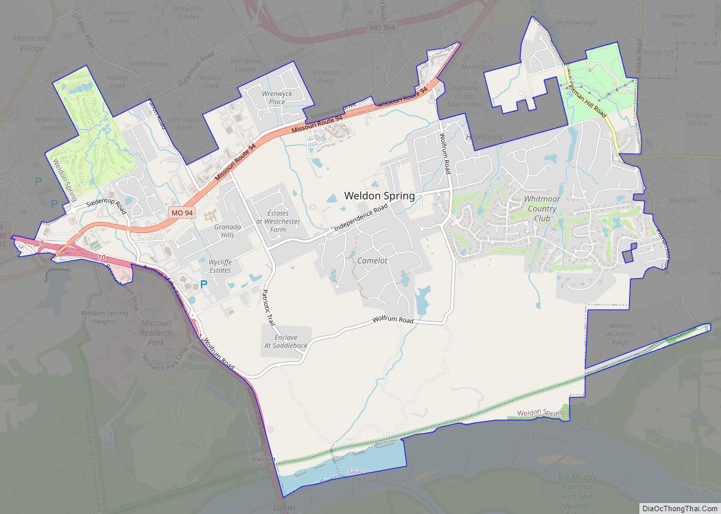
Weldon Spring is a city in St. Charles County, Missouri, United States. The population was 5,443 at the 2010 census. Weldon Spring city overview: Name: Weldon Spring city LSAD Code: 25 LSAD Description: city (suffix) State: Missouri County: St. Charles County Elevation: 541 ft (165 m) Total Area: 7.78 sq mi (20.14 km²) Land Area: 7.65 sq mi (19.81 km²) Water Area: 0.13 sq mi … Read more

Map of Weldon Spring Heights town

Map of Weldon Spring Heights town

Weldon Spring Heights is a village in St. Charles County, Missouri, United States. The population was 91 at the 2010 census. Weldon Spring Heights town overview: Name: Weldon Spring Heights town LSAD Code: 43 LSAD Description: town (suffix) State: Missouri County: St. Charles County Elevation: 617 ft (188 m) Total Area: 0.10 sq mi (0.25 km²) Land Area: 0.10 sq mi (0.25 km²) … Read more

Map of Weingarten CDP

Map of Weingarten CDP

Weingarten is an unincorporated community and census-designated place in Sainte Genevieve County, Missouri, United States. Weingarten CDP overview: Name: Weingarten CDP LSAD Code: 57 LSAD Description: CDP (suffix) State: Missouri County: Ste. Genevieve County Elevation: 804 ft (245 m) Total Area: 1.05 sq mi (2.72 km²) Land Area: 1.05 sq mi (2.72 km²) Water Area: 0.00 sq mi (0.00 km²) Total Population: 127 Population Density: 120.95/sq mi … Read more

Map of Webster Groves city

Map of Webster Groves city

Webster Groves is an inner-ring suburb of St. Louis in St. Louis County, Missouri, United States. The population was 22,995 at the 2010 census. The city is home to the main campus of Webster University. Webster Groves city overview: Name: Webster Groves city LSAD Code: 25 LSAD Description: city (suffix) State: Missouri County: St. Louis … Read more

Map of Webb City city

Map of Webb City, Missouri

Webb City is a city in Jasper County, Missouri, United States. The population was 13,031 at the 2020 census. It is part of the Joplin, Missouri Metropolitan Statistical Area. Webb City also has a police department, a fire department, and animal control services. Webb City overview: Name: Webb City LSAD Code: 25 LSAD Description: city … Read more

Map of Wentzville city

Map of Wentzville city

Wentzville is an exurb of St. Louis that is located in western St. Charles County, Missouri, United States. As of the 2020 census, the city had a total population of 44,372, making it the 15th largest city in Missouri. Wentzville has been the fastest growing city in Missouri, by percentage population increase, for two consecutive … Read more

Map of Wentworth village

Map of Wentworth village, Missouri

Wentworth is a village in northeastern Newton County, Missouri, United States. The population was 151 at the 2010 census. It is part of the Joplin, Missouri Metropolitan Statistical Area. Wentworth village overview: Name: Wentworth village LSAD Code: 47 LSAD Description: village (suffix) State: Missouri County: Newton County Elevation: 1,221 ft (372 m) Total Area: 0.18 sq mi (0.48 km²) Land … Read more

Map of Wellsville city, Missouri

Map of Wellsville city, Missouri

Wellsville is a city in Montgomery County, Missouri, United States. The population was 998 at the 2020 census. Wellsville city overview: Name: Wellsville city LSAD Code: 25 LSAD Description: city (suffix) State: Missouri County: Montgomery County Elevation: 817 ft (249 m) Total Area: 1.54 sq mi (3.99 km²) Land Area: 1.54 sq mi (3.98 km²) Water Area: 0.00 sq mi (0.01 km²) Total Population: 998 Population … Read more

Map of Wellston city, Missouri

Map of Wellston city, Missouri

Wellston is a city in St. Louis County, Missouri, United States, along the northwest border of the city of St. Louis. The population was 2,313 at the 2010 census. Wellston city overview: Name: Wellston city LSAD Code: 25 LSAD Description: city (suffix) State: Missouri County: St. Louis County Incorporated: 1909 Elevation: 548 ft (167 m) Total Area: … Read more

Map of Wellington city, Missouri

Map of Wellington city, Missouri

Wellington is a city in Lafayette County, Missouri, and part of the Kansas City metropolitan area within the United States. It is located approximately 35 miles east of Kansas City. The population was 812 at the 2010 census. Wellington city overview: Name: Wellington city LSAD Code: 25 LSAD Description: city (suffix) State: Missouri County: Lafayette … Read more

Map of West Plains city

Map of West Plains city

West Plains is a city in and the county seat of Howell County, Missouri, United States. The population was 12,184 at the 2020 census. West Plains city overview: Name: West Plains city LSAD Code: 25 LSAD Description: city (suffix) State: Missouri County: Howell County Elevation: 994 ft (303 m) Total Area: 13.33 sq mi (34.51 km²) Land Area: 13.30 sq mi (34.46 km²) … Read more

Map of West Line village

Map of West Line village

West Line is a village in Cass County, Missouri. The population was 97 at the 2010 census. It is part of the Kansas City metropolitan area. West Line village overview: Name: West Line village LSAD Code: 47 LSAD Description: village (suffix) State: Missouri County: Cass County Elevation: 902 ft (275 m) Total Area: 0.45 sq mi (1.18 km²) Land Area: … Read more