Map of Primrose village, Nebraska
Primrose is a village in Boone County, Nebraska, United States. The population was 61 at the 2010 census. Primrose village overview: Name: Primrose village LSAD Code: 47 LSAD Description: village (suffix) State: Nebraska County: Boone County Elevation: 1,824 ft (556 m) Total Area: 0.28 sq mi (0.72 km²) Land Area: 0.28 sq mi (0.72 km²) Water Area: 0.00 sq mi (0.00 km²) Total Population: 55 Population ... Read more
Map of Primrose village, Nebraska
Map of Preston village, Nebraska
Preston is a village in Richardson County in Southeastern Nebraska, United States. It is located within the Sac and Fox Reservation. The population was 19 at the 2020 census. Preston village overview: Name: Preston village LSAD Code: 47 LSAD Description: village (suffix) State: Nebraska County: Richardson County Elevation: 938 ft (286 m) Total Area: 0.06 sq mi (0.15 km²) Land ... Read more
Map of Preston village, Nebraska
Map of Prague village, Nebraska
Prague is a village in Saunders County, Nebraska, United States. The population was 291 at the 2020 census. It was named after Prague, capital of Bohemia (now in the Czech Republic). Prague village overview: Name: Prague village LSAD Code: 47 LSAD Description: village (suffix) State: Nebraska County: Saunders County Elevation: 1,342 ft (409 m) Total Area: 0.33 sq mi ... Read more
Map of Prague village, Nebraska
Map of Potter village, Nebraska
Potter is a village in Cheyenne County, Nebraska, United States. As of the 2010 census, the village population was 337. Potter village overview: Name: Potter village LSAD Code: 47 LSAD Description: village (suffix) State: Nebraska County: Cheyenne County Elevation: 4,400 ft (1,300 m) Total Area: 1.44 sq mi (3.73 km²) Land Area: 1.44 sq mi (3.73 km²) Water Area: 0.00 sq mi (0.00 km²) Total Population: ... Read more
Map of Potter village, Nebraska
Map of Poole CDP, Nebraska
Poole is a census-designated place (CDP) in Buffalo County, Nebraska, United States. It is part of the Kearney, Nebraska Micropolitan Statistical Area. The population of the CDP was 19 at the 2010 census. Poole CDP overview: Name: Poole CDP LSAD Code: 57 LSAD Description: CDP (suffix) State: Nebraska County: Buffalo County Elevation: 2,040 ft (620 m) Total ... Read more
Map of Poole CDP, Nebraska
Map of Ponca city
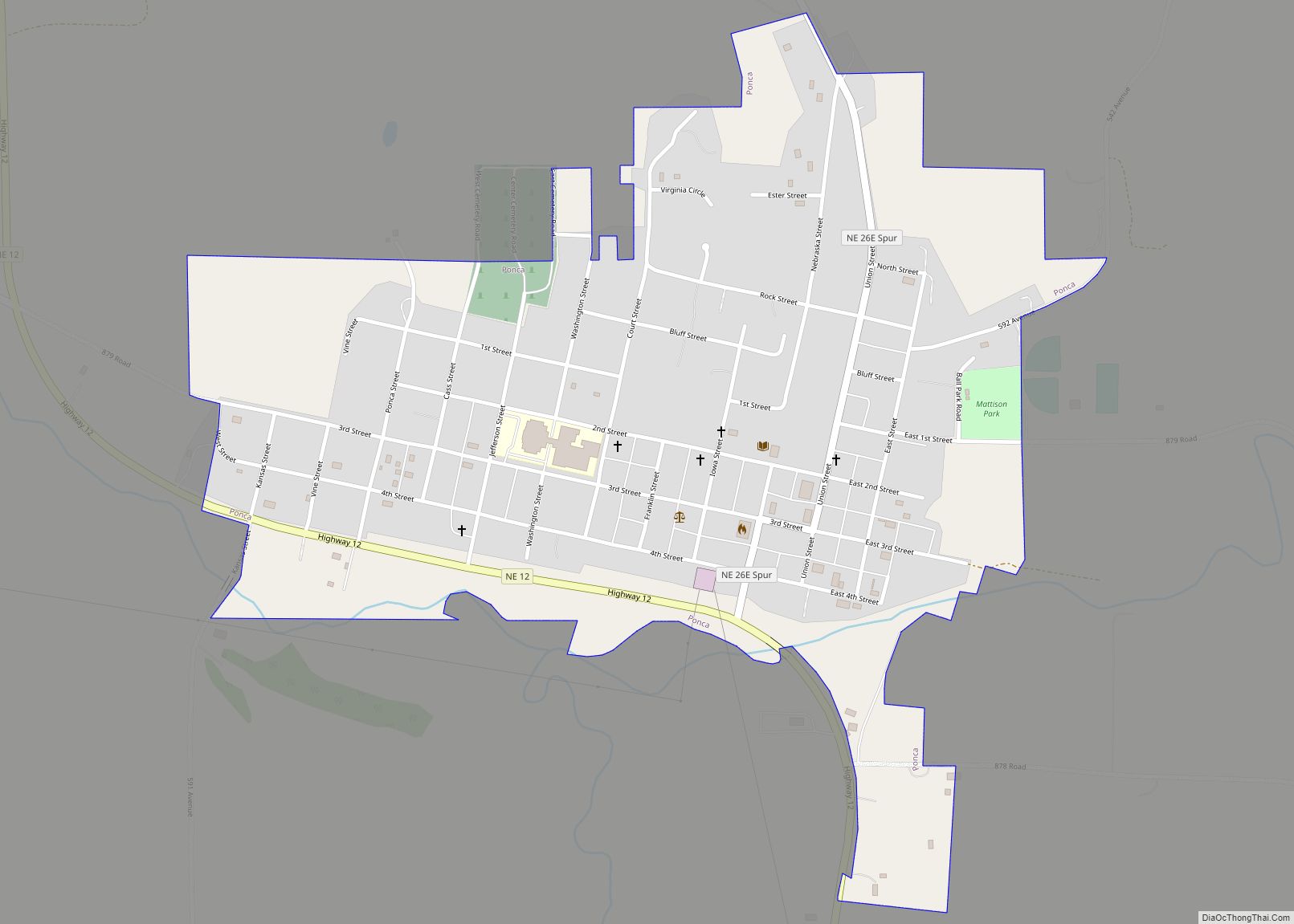
Ponca is a city and county seat of Dixon County, Nebraska, United States. The population was 961 at the 2010 census. Ponca city overview: Name: Ponca city LSAD Code: 25 LSAD Description: city (suffix) State: Nebraska County: Dixon County Incorporated: 1871 Elevation: 1,148 ft (350 m) Total Area: 0.77 sq mi (2.00 km²) Land Area: 0.77 sq mi (2.00 km²) Water Area: 0.00 sq mi ... Read more
Map of Ponca city
Map of Polk village, Nebraska
Polk is a village in Polk County, Nebraska, United States. The population was 322 at the 2010 census. Polk village overview: Name: Polk village LSAD Code: 47 LSAD Description: village (suffix) State: Nebraska County: Polk County Elevation: 1,742 ft (531 m) Total Area: 0.49 sq mi (1.27 km²) Land Area: 0.49 sq mi (1.27 km²) Water Area: 0.00 sq mi (0.00 km²) Total Population: 346 Population ... Read more
Map of Polk village, Nebraska
Map of Plymouth village, Nebraska
Plymouth is a village in Jefferson County, Nebraska, United States. The population was 363 at the 2020 census. Plymouth village overview: Name: Plymouth village LSAD Code: 47 LSAD Description: village (suffix) State: Nebraska County: Jefferson County Elevation: 1,430 ft (436 m) Total Area: 0.32 sq mi (0.82 km²) Land Area: 0.32 sq mi (0.82 km²) Water Area: 0.00 sq mi (0.00 km²) Total Population: 363 Population ... Read more
Map of Plymouth village, Nebraska
Map of Pleasanton village, Nebraska
Pleasanton is a village in Buffalo County in the state of Nebraska in the Midwestern United States. At the 2010 census, its population was 341. Pleasanton was platted in 1890 when the Union Pacific railroad was extended to that point. It got its name from its location in the Pleasant Valley of the Loup River. ... Read more
Map of Pleasanton village, Nebraska
Map of Pleasant Dale village
Pleasant Dale is a village in Seward County, Nebraska, United States. It is part of the Lincoln, Nebraska Metropolitan Statistical Area. The population was 205 at the 2010 census. Pleasant Dale village overview: Name: Pleasant Dale village LSAD Code: 47 LSAD Description: village (suffix) State: Nebraska County: Seward County Elevation: 1,319 ft (402 m) Total Area: 0.11 sq mi ... Read more
Map of Pleasant Dale village
Map of Randolph city, Nebraska
Randolph is a city in Cedar County, Nebraska, United States. The population was 881 at the 2020 census. It refers to itself as “The Honey Capital of the Nation” due to the per-capita number of bee keeping families. Randolph city overview: Name: Randolph city LSAD Code: 25 LSAD Description: city (suffix) State: Nebraska County: Cedar ... Read more
Map of Randolph city, Nebraska
Map of Ralston city, Nebraska
Ralston is a city in Douglas County, Nebraska, United States. The population was 6,494 at the 2020 census. A suburb of Omaha, Ralston is surrounded on three sides by the city of Omaha by 84th, 72nd, and L Streets, and by Sarpy County (Harrison Street) on the south side. Ralston city overview: Name: Ralston city ... Read more
Map of Ralston city, Nebraska