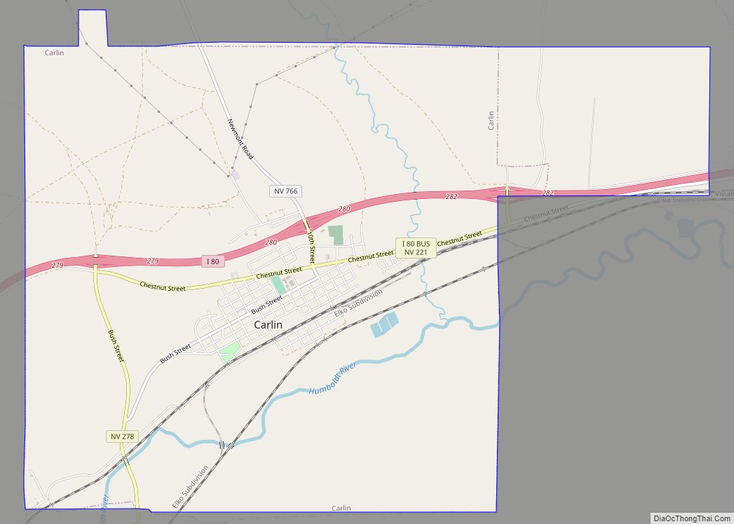
Map of Caliente city

Map of Caliente city

Caliente /kæliˈɛni/, /kæliˈɛnti/, formerly known as Culverwell and Calientes, is a city in Lincoln County, Nevada, United States. Its elevation is 4,300 feet (1,300 m). The population was 1,130 at the 2010 census, making it the least populated incorporated city in Nevada. The city’s name originated from the nearby hot springs, as “caliente” is the Spanish … Read more

Map of Cal-Nev-Ari CDP

Map of Cal-Nev-Ari CDP

Cal-Nev-Ari is a census-designated place on U.S. Route 95 in Clark County, Nevada, United States, near the state’s southernmost point. As of the 2010 census, the town had a population of 244. The town’s name is a syllabic abbreviation of California, Nevada and Arizona. Cal-Nev-Ari was created in the mid-1960s by Nancy and Everette “Slim” … Read more

Map of Empire CDP, Nevada

Map of Empire CDP, Nevada

Empire is an unincorporated community and census-designated place (CDP) in Washoe County, Nevada, with a population estimated at 65 (2021). It is part of the Reno–Sparks Metropolitan Statistical Area; before the 2010 census, it was part of the Gerlach–Empire census-designated place. The nearest town, Nixon, is 60 miles (97 km) to the south on a reservation … Read more

Map of Ely city, Nevada

Map of Ely city, Nevada

Ely (/ˈiːli/, EE-lee) is the largest city and county seat of White Pine County, Nevada, United States. Ely was founded as a stagecoach station along the Pony Express and Central Overland Route. In 1906 copper was discovered. Ely’s mining boom came later than the other towns along US 50. The railroads connecting the transcontinental railroad to … Read more

Map of Elko city

Map of Elko city, Nevada

Coordinates: 40°50′N 115°46′W / 40.833°N 115.767°W / 40.833; -115.767 Elko (Shoshoni: Natakkoa, “Rocks Piled on One Another”) is the largest city in and county seat of Elko County, Nevada, United States. With a 2020 population of 20,564, Elko is currently growing at a rate of 0.31% annually and its population has increased by 11.86% since … Read more

Map of East Valley CDP

Map of East Valley CDP

East Valley is a census-designated place (CDP) in Douglas County, Nevada, United States. The population was 1,474 at the 2010 census. East Valley CDP overview: Name: East Valley CDP LSAD Code: 57 LSAD Description: CDP (suffix) State: Nevada County: Douglas County Elevation: 4,892 ft (1,491 m) Total Area: 9.96 sq mi (25.80 km²) Land Area: 9.84 sq mi (25.48 km²) Water Area: 0.12 sq mi … Read more

Map of Dyer CDP, Nevada

Map of Dyer CDP, Nevada

Dyer is an unincorporated town, located in Fish Lake Valley, Esmeralda County, Nevada, United States. It had a population of 324 as of the 2018 American Community Survey. The town serves the surrounding area’s sparse rural population of mainly ranchers and indigenous Paiute people. The town has a gas station/store, cafe, post office and airport. … Read more

Map of Dry Valley CDP

Map of Dry Valley CDP

Dry Valley is a census-designated place in Lincoln County, Nevada, United States. As of the 2020 census it had a population of 49. Dry Valley CDP overview: Name: Dry Valley CDP LSAD Code: 57 LSAD Description: CDP (suffix) State: Nevada County: Lincoln County Elevation: 5,154 ft (1,571 m) Total Area: 3.79 sq mi (9.80 km²) Land Area: 3.79 sq mi (9.80 km²) Water … Read more

Map of Fallon city, Nevada

Map of Fallon city, Nevada

Fallon is a city in Churchill County in the U.S. state of Nevada. The population was 9,327 at time of the 2020 census. Fallon is the county seat of Churchill County and is located in the Lahontan Valley. Fallon city overview: Name: Fallon city LSAD Code: 25 LSAD Description: city (suffix) State: Nevada County: Churchill … Read more

Map of Fallon Station CDP

Map of Fallon Station CDP

Fallon Station is a census-designated place (CDP) in Churchill County, Nevada, United States. The population was 705 at the 2010 census. Fallon Station CDP overview: Name: Fallon Station CDP LSAD Code: 57 LSAD Description: CDP (suffix) State: Nevada County: Churchill County Elevation: 3,927 ft (1,197 m) Total Area: 2.84 sq mi (7.36 km²) Land Area: 2.84 sq mi (7.36 km²) Water Area: 0.00 sq mi … Read more

Map of Eureka CDP, Nevada

Map of Eureka CDP, Nevada

Eureka is an unincorporated town and census-designated places in and the county seat of Eureka County, Nevada, United States. With a population of 480 as of the 2018 American Community Survey 5-Year Estimates, it is by far the largest community in Eureka County. Attractions include the Eureka Opera House (built in 1880 and restored in … Read more

Map of Enterprise CDP, Nevada

Map of Enterprise CDP, Nevada

Enterprise is an unincorporated town in the Las Vegas Valley in Clark County, Nevada, United States. The population was 221,831 at the 2020 U.S. Census, up from 14,676 at the 2000 census. It was founded on December 17, 1996. Like other unincorporated towns in the Las Vegas Valley, it uses Las Vegas ZIP codes for … Read more