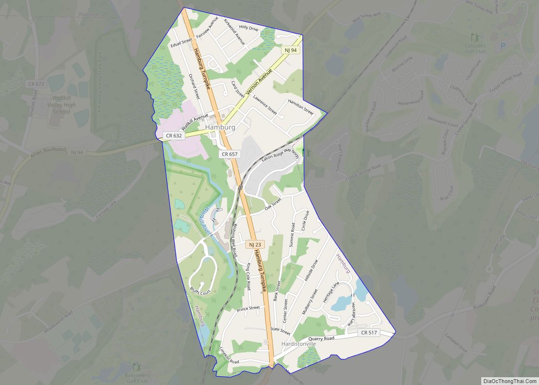
Map of Hancocks Bridge CDP

Map of Hancocks Bridge CDP

Hancocks Bridge CDP overview: Name: Hancocks Bridge CDP LSAD Code: 57 LSAD Description: CDP (suffix) State: New Jersey County: Salem County FIPS code: 3429520 Online Interactive Map Hancocks Bridge online map. Source: Basemap layers from Google Map, Open Street Map (OSM), Arcgisonline, Wmflabs. Boundary Data from Database of Global Administrative Areas. Hancocks Bridge location map. … Read more

Map of Hampton borough, New Jersey

Map of Hampton borough, New Jersey

Hampton borough overview: Name: Hampton borough LSAD Code: 21 LSAD Description: borough (suffix) State: New Jersey County: Hunterdon County FIPS code: 3429460 Online Interactive Map Hampton online map. Source: Basemap layers from Google Map, Open Street Map (OSM), Arcgisonline, Wmflabs. Boundary Data from Database of Global Administrative Areas. Hampton location map. Where is Hampton borough? … Read more

Map of Highland Park borough, New Jersey

Map of Highland Park borough, New Jersey

Highland Park is a borough in Middlesex County, in the U.S. state of New Jersey, in the New York City metropolitan area. The borough is located on the northern banks of the Raritan River, in the Raritan Valley region. As of the 2020 United States census, the borough’s population was 15,072, an increase of 1,090 … Read more

Map of Highland Lakes CDP, New Jersey

Map of Highland Lakes CDP, New Jersey

Highland Lakes is an unincorporated community and census-designated place (CDP) located within Vernon Township, in Sussex County, in the U.S. state of New Jersey. As of the 2010 United States Census, the CDP’s population was 4,933. Highland Lakes has its own Post Office with the ZIP code 07422. Highland Lakes CDP overview: Name: Highland Lakes … Read more

Map of High Bridge borough, New Jersey

Map of High Bridge borough, New Jersey

High Bridge is a borough in Hunterdon County, in the U.S. state of New Jersey. As of the 2020 United States census, the borough’s population was 3,546, a decrease of 102 (−2.8%) from the 2010 census count of 3,648, which in turn reflected a decline of 128 (−3.4%) from the 3,776 counted in the 2000 … Read more

Map of Hi-Nella borough

Map of Hi-Nella borough

Hi-Nella is a borough in Camden County, in the U.S. state of New Jersey. The borough is the state’s ninth-smallest municipality. As of the 2020 United States census, the borough’s population was 927, an increase of 57 (+6.6%) from the 2010 census count of 870, which in turn reflected a decline of 159 (−15.5%) from … Read more

Map of Helmetta borough

Map of Helmetta borough

Helmetta is a borough in Middlesex County, in the U.S. state of New Jersey. The borough is located in the heart of the Raritan Valley region, with Manalapan Brook (a Raritan River tributary) flowing through the center of the community. As of the 2020 United States census, the borough’s population was 2,455, its highest decennial … Read more

Map of Heathcote CDP

Map of Heathcote CDP

Heathcote is an unincorporated community and census-designated place (CDP) located within South Brunswick Township, in Middlesex County, New Jersey, United States. As of the 2010 United States Census, the CDP’s population was 5,821. Heathcote CDP overview: Name: Heathcote CDP LSAD Code: 57 LSAD Description: CDP (suffix) State: New Jersey County: Middlesex County Elevation: 184 ft (56 m) … Read more

Map of Hawthorne borough, New Jersey

Map of Hawthorne borough, New Jersey

Hawthorne is a borough in Passaic County, in the U.S. state of New Jersey. As of the 2020 United States census, the borough’s population was 19,637, an increase of 846 (+4.5%) from the 2010 census count of 18,791, which in turn reflected an increase of 573 (+3.1%) from the 18,218 counted in the 2000 census. … Read more

Map of Haworth borough

Map of Haworth borough, New Jersey

Haworth (/hɑː.wərθ/ HAH-worth) is a borough in Bergen County, in the U.S. state of New Jersey. As of the 2020 United States census, the borough’s population was 3,343, a decrease of 39 (−1.2%) from the 2010 census count of 3,382, which in turn reflected a decline of 8 (−0.2%) from the 3,390 counted at the … Read more

Map of Hasbrouck Heights borough

Map of Hasbrouck Heights borough

Hasbrouck Heights (pronounced HAZ-brook /ˈhæz.bɹʊk/) is a borough in Bergen County, in the U.S. state of New Jersey. As of the 2010 United States Census, the borough’s population was 11,842, reflecting an increase of 180 (+1.5%) from the 11,662 counted in the 2000 Census, which had in turn increased by 174 (+1.5%) from the 11,488 … Read more

Map of Harvey Cedars borough

Map of Harvey Cedars borough

Harvey Cedars is a coastal borough situated on the Jersey Shore, in southern Ocean County, in the U.S. state of New Jersey. The borough encompasses a narrow strip of Long Beach Island fronting both the Atlantic Ocean and Barnegat Bay. As of the 2020 United States census, the borough’s population was 391, its highest decennial … Read more