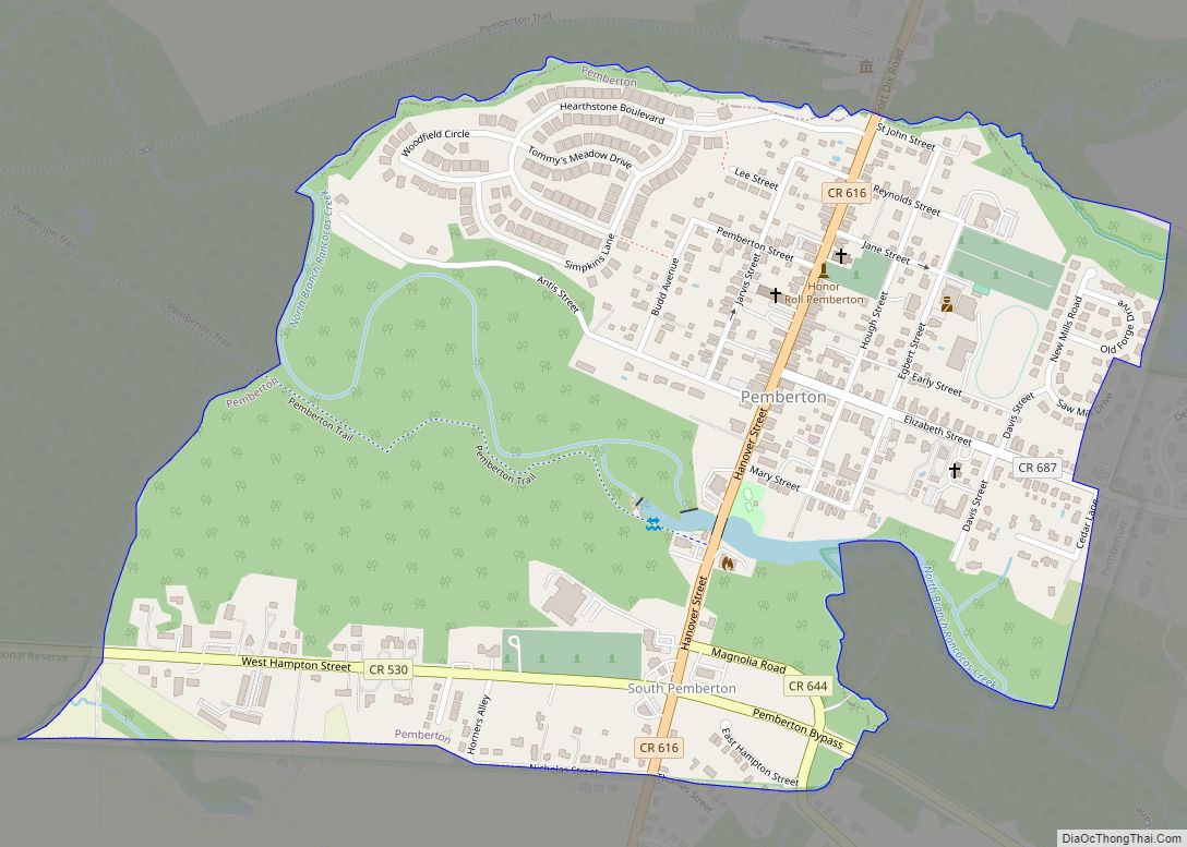
Map of Phillipsburg town, New Jersey
Phillipsburg is a town located along the Delaware River that is the most populous municipality in Warren County, in the U.S. state of New Jersey. As of the 2020 United States census, the town’s population was 15,249, an increase of 299 (+2.0%) from the 2010 census count of 14,950, which in turn reflected a decline ... Read more
Map of Phillipsburg town, New Jersey
Map of Perth Amboy city
Perth Amboy is a city in Middlesex County, in the U.S. state of New Jersey. Perth Amboy is part of the New York metropolitan area. As of the 2020 United States census, the city’s population was 55,436, an increase of 4,622 (+9.1%) from the 2010 census count of 50,814, which in turn reflected an increase ... Read more
Map of Perth Amboy city
Map of Pennsville CDP
Pennsville is an unincorporated community and census-designated place (CDP) located within Pennsville Township, in Salem County, New Jersey, United States. As of the 2010 United States Census, the CDP’s population was 11,888. Pennsville CDP and Pennsville Township are not coextensive, with the CDP covering 42.4% of the 24.588 miles (39.571 km) of the township as a ... Read more
Map of Pennsville CDP
Map of Penns Grove borough
Penns Grove is a borough in Salem County, in the U.S. state of New Jersey. As of the 2020 United States census, the borough’s population was 4,837, a decrease of 310 (−6.0%) from the 2010 census count of 5,147, which in turn reflected an increase of 261 (+5.3%) from the 4,886 counted in the 2000 ... Read more
Map of Penns Grove borough
Map of Point Pleasant borough, New Jersey
Point Pleasant is a borough situated on the Jersey Shore, in northern Ocean County, in the U.S. state of New Jersey. As of the 2020 United States census, the borough’s population was 18,941, an increase of 549 (+3.0%) from the 2010 census count of 18,392, which in turn reflected a decline of 914 (−4.7%) from ... Read more
Map of Point Pleasant borough, New Jersey
Map of Point Pleasant Beach borough
Point Pleasant Beach is a coastal borough situated on a Jersey Shore, and the northernmost community directly facing the Atlantic Ocean within Ocean County, in the U.S. state of New Jersey. It lies at the northern end of the Barnegat Peninsula, which serves as a barrier island separating Barnegat Bay from the open Atlantic Ocean. ... Read more
Map of Point Pleasant Beach borough
Map of Pleasantville city, New Jersey
Pleasantville is a city in Atlantic County, in the U.S. state of New Jersey. As of the 2020 United States census, the city’s population was 20,629, its highest decennial count ever and an increase of 380 (+1.9%) from the 2010 census count of 20,249, which in turn had reflected an increase of 1,237 (+6.5%) from ... Read more
Map of Pleasantville city, New Jersey
Map of Pleasant Plains CDP, New Jersey
Pleasant Plains is an unincorporated community and census-designated place (CDP) located in Franklin Township, in Somerset County, New Jersey, United States. As of the 2010 United States Census, the CDP’s population was 922. Having no distinct boundaries, a large area in the center of Franklin Township centered on the intersections of South Middlebush Road (County ... Read more
Map of Pleasant Plains CDP, New Jersey
Map of Plainsboro Center CDP
Plainsboro Center is an unincorporated community and census-designated place (CDP) located within Plainsboro Township, in Middlesex County, New Jersey, United States. As of the 2010 United States Census, the CDP’s population was 2,712. Plainsboro Center CDP overview: Name: Plainsboro Center CDP LSAD Code: 57 LSAD Description: CDP (suffix) State: New Jersey County: Middlesex County Elevation: ... Read more
Map of Plainsboro Center CDP
Map of Plainfield city, New Jersey
Plainfield is a city in Union County, in the U.S. state of New Jersey, known by its nickname as “The Queen City.” The city is both a regional hub for Central New Jersey and a bedroom suburb of the New York Metropolitan area, located within the core of the Raritan Valley region. As of the ... Read more
Map of Plainfield city, New Jersey
Map of Pitman borough
Pitman is a borough in Gloucester County, in the U.S. state of New Jersey. As of the 2020 United States census, the borough’s population was 8,780, a decrease of 231 (−2.6%) from the 2010 census count of 9,011, which in turn reflected a decline of 320 (−3.4%) from the 9,331 in the 2000 census. The ... Read more
Map of Pitman borough
Map of Pine Valley borough, New Jersey
Pine Valley borough overview: Name: Pine Valley borough LSAD Code: 21 LSAD Description: borough (suffix) State: New Jersey County: Camden County FIPS code: 3458920 Online Interactive Map Pine Valley online map. Source: Basemap layers from Google Map, Open Street Map (OSM), Arcgisonline, Wmflabs. Boundary Data from Database of Global Administrative Areas. Pine Valley location map. ... Read more
Map of Pine Valley borough, New Jersey