Pompton Lakes is a borough in Passaic County, in the U.S. state of New Jersey. As of the 2020 United States census, the borough’s population was 11,127, an increase of 30 (+0.3%) from the 2010 census count of 11,097, which in turn reflected an increase of 457 (+4.3%) from the 10,640 counted in the 2000 Census, which had in turn increased by 101 (+1.0%) from the 10,539 counted in the 1990 Census.
Pompton Lakes was established on February 26, 1895, from portions of Pompton Township, based on the results of a referendum held three days earlier. The borough was named for the Pompton people, a sub-tribe of Native Americans who lived in the area. It was the first borough to be formed in Passaic County as part of the “boroughitis” that had struck the state at the time. Pompton Lakes did not acquire territory from more than one township, which would have entitled the borough to a seat on the County’s Board of Chosen Freeholders.
An outer-ring suburb of New York City, Pompton Lakes is located approximately 20 miles (32 km) northwest of Midtown Manhattan. From the higher mountains in and around the borough one can see the New York skyline. Three rivers, the Ramapo, Pequannock and Wanaque, run through the borough, which historically provided much of the energy for various industries in the borough. In the mid-20th century, Pompton Lakes served as a local shopping destination, but lost its status as shopping malls opened in the area in the 1970s and 1980s.
| Name: | Pompton Lakes borough |
|---|---|
| LSAD Code: | 21 |
| LSAD Description: | borough (suffix) |
| State: | New Jersey |
| County: | Passaic County |
| Founded: | 1682 |
| Incorporated: | February 26, 1895 |
| Elevation: | 217 ft (66 m) |
| Total Area: | 3.16 sq mi (8.19 km²) |
| Land Area: | 2.89 sq mi (7.48 km²) |
| Water Area: | 0.27 sq mi (0.71 km²) 8.67% |
| Total Population: | 11,127 |
| Population Density: | 3,854.2/sq mi (1,488.1/km²) |
| ZIP code: | 07442 |
| Area code: | 973 |
| FIPS code: | 3460090 |
| GNISfeature ID: | 0885359 |
| Website: | www.pomptonlakes-nj.gov |
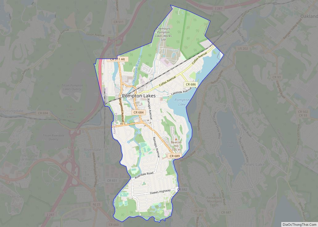
Online Interactive Map
Click on ![]() to view map in "full screen" mode.
to view map in "full screen" mode.
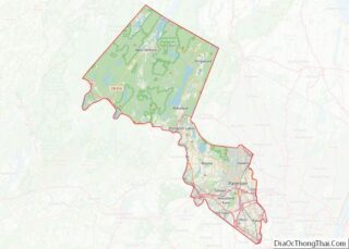
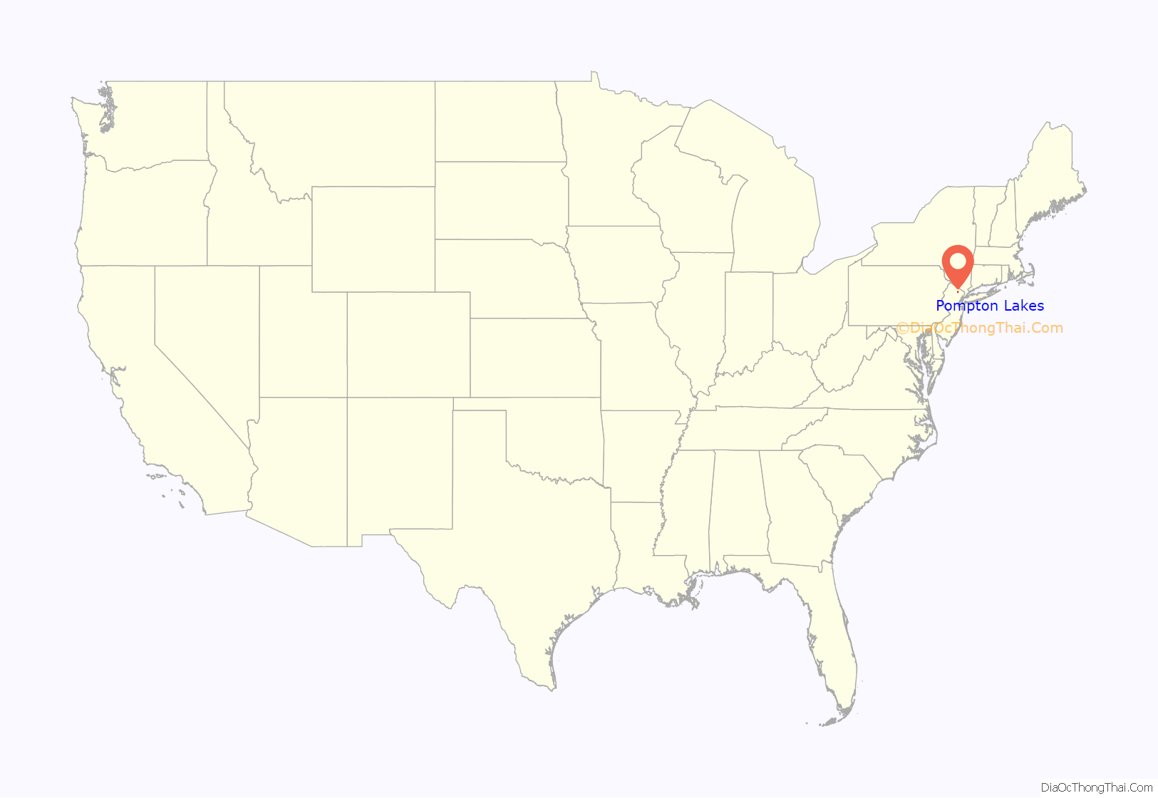
Pompton Lakes location map. Where is Pompton Lakes borough?
History
Dutch settlers began to settle in the area that is now Pompton Lakes in the 1680s, purchasing farmland from the local Lenape Native Americans.
The presence of iron ore and the availability of hydropower were initial catalysts for the early development of the Pompton area. An ironworks was constructed on the Pompton River in the early 1700s, which produced munitions for the French and Indian War, the Revolutionary War and the War of 1812.
Pompton was situated along the main north–south route during the Revolutionary War, and as such the Continental Army passed through often. Casparus Schuyler, a member of the prominent Schuyler family, owned a tavern in the town that became known as the Yellow Tavern or the Yellow Cottage, and the various army encampments in the area supplied much of the business.
General George Washington and his army stayed in the Pompton area twice during the course of the war, and he visited the Yellow Tavern both times. He first visited on July 11, 1777, when he met with local ironmaster Robert Erskine at the tavern. François-Jean de Chastellux, a major general in the French Expeditionary Force led by General Rochambeau, visited the Yellow Tavern on his way from Philadelphia to New England in December 1780, and remarked on his experience there in an account published later. Washington returned to the tavern on March 30, 1782, as he traveled north with his wife Martha. During this time, it was serving as the winter headquarters of Colonel Phillip Van Cortlandt. The tavern was torn down around 1900 to widen the adjacent road, and the site is noted by a historical marker.
Pompton Township was formed shortly after the Revolution, in 1797. During the Civil War, knives, saws, nails, and springs for railroad cars were manufactured at the Pompton Ironworks. The Morris Canal, completed in 1832, was linked to the town via the Pompton Feeder, which barges used to supply coal to blast furnaces. Despite this, Pompton remained predominantly rural through the 19th century, and various summer resorts around Pompton Lake served vacationing New Yorkers. The New York, Susquehanna and Western Railroad opened a local train station in the late 1870s, driving further development in the town. In 1895, Pompton Lakes voted to split from Pompton Township, and the borough was officially incorporated on February 26 of that year.
The population of Pompton Lakes increased during the early 1900s, due to the rapid growth of local employers like the German Artistic Weaving Company and the Smith Powder Works. The latter company was purchased in 1905 by E.I. du Pont de Nemours and Company and formed the basis of the DuPont Pompton Lakes Works, which operated in the borough until 1994.
In 1923, Joseph “Doc” Bier opened a “health farm” in Pompton Lakes, where boxers such as Pancho Villa and Jimmy McLarnin trained. In 1935, Joe Louis began training at the camp, and continued to use the camp until his retirement in 1949. He prepared for his famed bout with Max Schmeling there, and often invited local children to watch him practice. During his time in the borough he held boxing exhibitions at the camp to raise $2,600 for the purchase of an ambulance and an additional $2,000 to help build a police communications tower. The camp closed in the 1950s.
In 1938, Reaction Motors successfully designed and perfected the world’s first regenerative cooling rocket at a basement laboratory in a building in downtown Pompton Lakes. The technology they invented made liquid-fueled rockets capable of burning for long enough periods to be practical, and all future liquid-fueled rockets would build off this technology. The company tested this rocket at Lake Inez in the borough, not far from the laboratory it was built in.
Decades-old industrial pollution and its connection to cancer and other illness among residents in a section of the borough was the subject of a week-long front-page investigative series in The Record newspaper in February 2018. The four-part series documented ground and water pollution that has impacted hundreds of homes surrounding a DuPont munitions plant that had operated for decades in the area, and the impact on the health of nearby residents exposed to the pollutants.
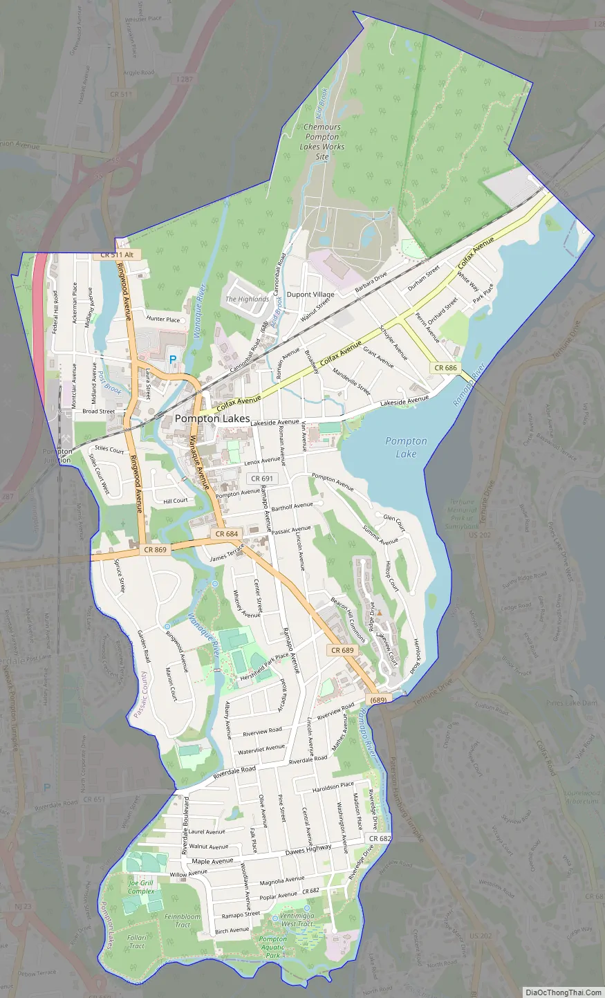
Pompton Lakes Road Map
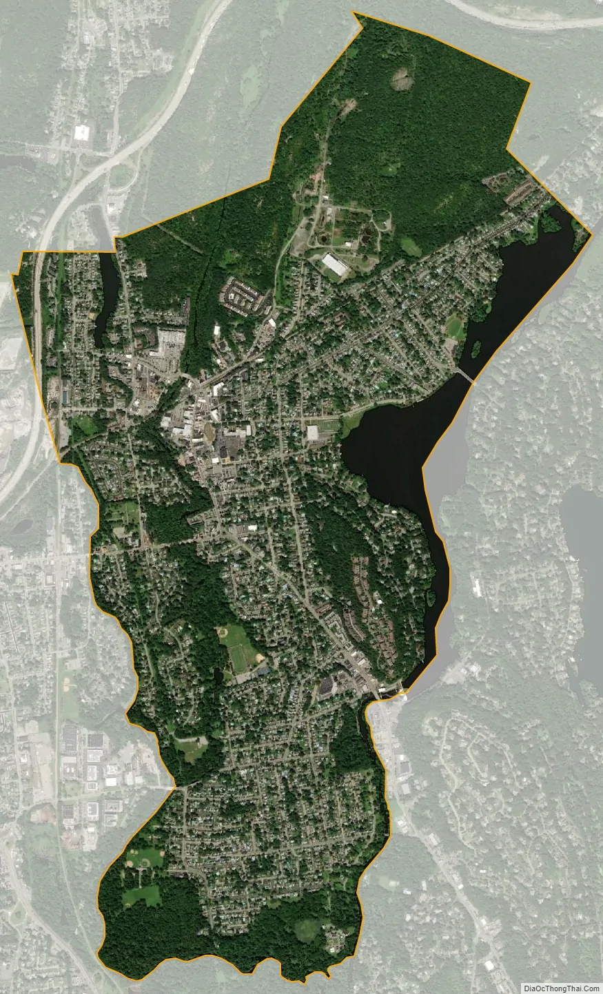
Pompton Lakes city Satellite Map
Geography
According to the United States Census Bureau, the borough had a total area of 3.16 square miles (8.19 km), including 2.89 square miles (7.48 km) of land and 0.27 square miles (0.71 km) of water (8.67%).
The borough borders the municipalities of Bloomingdale, Wanaque and Wayne in Passaic County; Oakland in Bergen County; and Riverdale and Pequannock in Morris County.
Much of the borough sits in a valley formed by the confluence of the Ramapo, Pequannock, and Wanaque rivers, which leads to common flooding events, the most recent of which was in 2011. A few taller hills ring the valley, including Federal Hill, which is notable as the site of the Pompton Mutiny, a revolt of Continental Army troops that occurred there on January 20, 1781, under the command of Colonel Israel Shreve.
See also
Map of New Jersey State and its subdivision: Map of other states:- Alabama
- Alaska
- Arizona
- Arkansas
- California
- Colorado
- Connecticut
- Delaware
- District of Columbia
- Florida
- Georgia
- Hawaii
- Idaho
- Illinois
- Indiana
- Iowa
- Kansas
- Kentucky
- Louisiana
- Maine
- Maryland
- Massachusetts
- Michigan
- Minnesota
- Mississippi
- Missouri
- Montana
- Nebraska
- Nevada
- New Hampshire
- New Jersey
- New Mexico
- New York
- North Carolina
- North Dakota
- Ohio
- Oklahoma
- Oregon
- Pennsylvania
- Rhode Island
- South Carolina
- South Dakota
- Tennessee
- Texas
- Utah
- Vermont
- Virginia
- Washington
- West Virginia
- Wisconsin
- Wyoming