Plainfield is a city in Union County, in the U.S. state of New Jersey, known by its nickname as “The Queen City.” The city is both a regional hub for Central New Jersey and a bedroom suburb of the New York Metropolitan area, located within the core of the Raritan Valley region. As of the 2020 United States census, the city’s population, majority Latino for the first time, was 54,586. This was an increase of 4,778 (+9.6%) from the 2010 census count of 49,808, which in turn reflected an increase of 1,979 (+4.1%) from the 47,829 counted in the 2000 census. The Census Bureau’s Population Estimates Program calculated that the city’s population was 54,936 in 2021, ranking the city the 723rd-most-populous in the country.
The area of present-day Plainfield was originally formed as Plainfield Township, a township that was created on April 5, 1847, from portions of Westfield Township, while the area was still part of Essex County. On March 19, 1857, Plainfield Township became part of the newly created Union County.
Plainfield was incorporated as a city by an act of the New Jersey Legislature on April 21, 1869, from portions of Plainfield Township, based on the results of a referendum held that same day. The city and township coexisted until March 6, 1878, when Plainfield Township was dissolved and parts were absorbed by Plainfield city, with the remainder becoming Fanwood Township (now known as Scotch Plains).
The name “Plainfield”, also used in both North Plainfield and South Plainfield, is derived from a local estate or from its scenic location.
| Name: | Plainfield city |
|---|---|
| LSAD Code: | 25 |
| LSAD Description: | city (suffix) |
| State: | New Jersey |
| County: | Union County |
| Incorporated: | April 21, 1869 |
| Elevation: | 95 ft (29 m) |
| Total Area: | 5.97 sq mi (15.46 km²) |
| Land Area: | 5.96 sq mi (15.43 km²) |
| Water Area: | 0.01 sq mi (0.02 km²) 0.15% |
| Total Population: | 54,586 |
| Population Density: | 9,160.3/sq mi (3,536.8/km²) |
| Area code: | 732 and 908 |
| FIPS code: | 3459190 |
| GNISfeature ID: | 0885355 |
| Website: | www.plainfieldnj.gov |
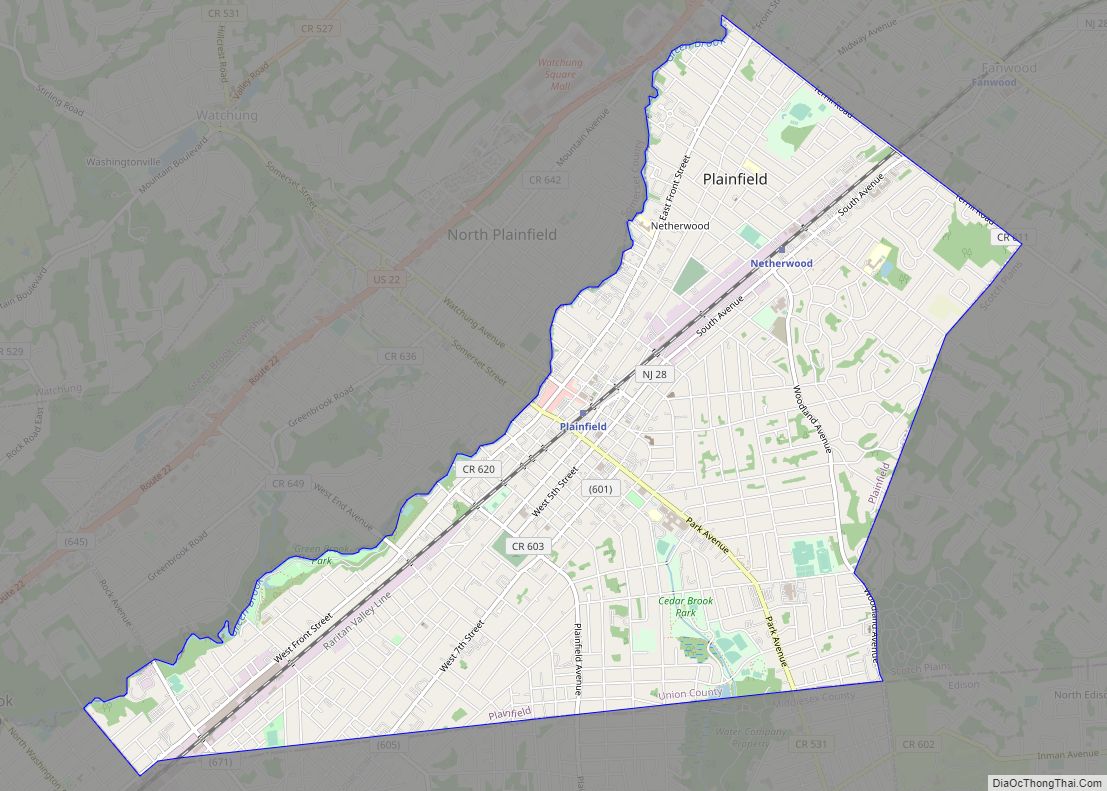
Online Interactive Map
Click on ![]() to view map in "full screen" mode.
to view map in "full screen" mode.
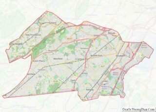
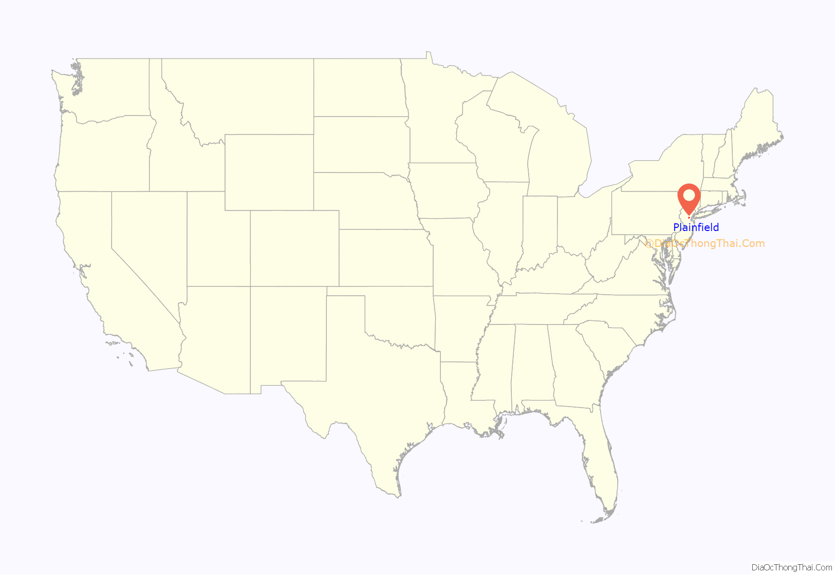
Plainfield location map. Where is Plainfield city?

History
Plainfield was settled in 1684 by Quakers, and incorporated as a city in 1869. Formerly a bedroom suburb in the New York metropolitan area, it has become the urban center of 10 closely allied municipalities, with diversified industries, including printing and the manufacture of chemicals, clothing, electronic equipment, and vehicular parts. Among the several 18th-century buildings remaining are a Friends’ meetinghouse (1788), the Martine house (1717), and the Nathaniel Drake House (1746), known as George Washington’s headquarters during the Battle of Short Hills in June 1777. Nearby Washington Rock is a prominent point of the Watchung Mountains and is reputed to be the vantage point from which Washington watched British troop movements.
The “Queen City” moniker arose in the second half of the 19th century. Plainfield had been developing a reputation during this period as featuring a climate that was beneficial for respiratory ailments. In 1886, in an effort to publicize the climate, local newspaper publisher Thomas W. Morrison began to use the slogan “Colorado of the East” to promote Plainfield. As Denver, Colorado, was known as the “Queen City of the Plains,” the slogan for Plainfield eventually became abbreviated to “The Queen City.”
In 1902, the New Jersey Legislature approved measures that would have allowed the borough of North Plainfield to become part of Union County (a measure repealed in 1903) and to allow for a merger of North Plainfield with the City of Plainfield subject to the approval of a referendum by voters in both municipalities.
Plainfield is the birthplace of P-Funk. George Clinton founded The Parliaments while working in a Plainfield barber shop. Parliament-Funkadelic was inducted in the Rock and Roll Hall of Fame in 1997. Plainfield has been home to former New Jersey governor James McGreevey.
In sports history, Plainfield is the birthplace and/or home of several current and former athletes, including professionals and well-known amateurs. Included in their number are Milt Campbell, the 1956 Olympic Decathlon gold medalist (the first African-American to earn this title), Joe Black, the first African-American pitcher to win a World Series game, Jeff Torborg, former MLB player, coach and manager, former Duke University and Chicago Bull basketball player Jay Williams, and Vic Washington, NFL player.
Plainfield’s history as a place to call home for the 19th and 20th century wealthy has led to a significant and preserved suburban architectural legacy. An influx of Wall Street money led to the creation of what was called Millionaires’ Row after the opening of the railway in the 19th century.
There are numerous sites, including homes, parks, and districts in the city that are listed on the National Register of Historic Places. While not listed, the Plainfield Armory, a prominent landmark completed in 1932, was sold by the state in 2013 as surplus property.
Plainfield’s wealthy northeast corner, known as the “Sleepy Hollow” section of the city, was and still is characterized by its array of finely landscaped streets and neighborhoods with homes defined by a broad array of architectural styles, most built during the first half of the twentieth century. From the tree-lines neighborhoods, it can be seen that the lot sizes vary, but the stateliness and distinction of each house is evident, whether a stately Queen Anne mansion or gingerbread cottage. Most lots are nicely landscaped and semi or fully private.
Plainfield was affected by the Plainfield Rebellion in July 1967. This civil disturbance occurred in the wake of the larger Newark riots. A Plainfield police officer was killed, about fifty people were injured, and several hundred thousand dollars of property was damaged by looting and arson. The New Jersey National Guard restored order after three days of unrest. This civil unrest caused a massive white flight, characterized by the percentage of Black residents rising from 40% in 1970 to 60% a decade later.
Author and Plainfield native Isaiah Tremaine published Insurrection in 2017 as a mournful accounting of the Plainfield riots—and subsequent racial tensions at Plainfield High School—from his perspective as a Black teenager living in the city with both white and Black friends at the time. Prior to the rebellion, Plainfield was a regional shopping and entertainment center. Residents of nearby Union, Middlesex and Somerset counties would drive to shop and explore the business districts of Plainfield. Other than during the holidays, peak shopping times Plainfield were Thursday nights and Saturday, when Front Street and the areas around it bustled.
Plainfield had several entertainment venues at that time. At the peak, there were four operating movie theaters: the Strand, the Liberty, the Paramount and the Oxford theaters.
Manufacturers of heavy goods included Chelsea Fan Corp., Mack Truck and National Starch and Chemical Corp. Plainfield Iron and Metal maintained a large scrapyard in the West End.
Plainfield Road Map
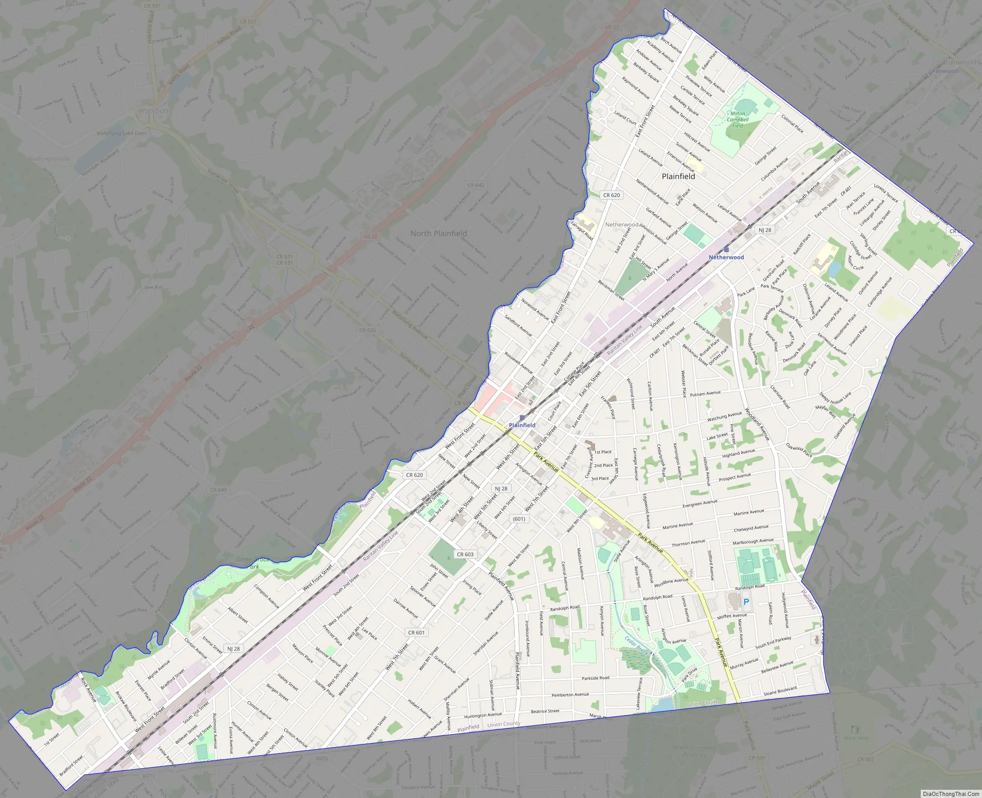
Plainfield city Satellite Map

Geography
According to the United States Census Bureau, the city had a total area of 5.97 square miles (15.5 km), including 5.96 square miles (15.4 km) of land and 0.01 square miles (0.026 km) of water (0.15%).
Unincorporated communities, localities and place names located partially or completely within the city include Netherwood.
The city is located in Central Jersey on the southwestern edge of Union County and is bordered by nine municipalities. In Union County are Scotch Plains to the north and east and Fanwood to the northeast. In Middlesex County, are South Plainfield and Piscataway to the south; Dunellen to the southwest and Edison to the southeast. In Somerset County, Green Brook Township lies to the northwest, North Plainfield lies to the north and Watchung borders to the northwest.
Plainfield is in the Raritan Valley, a line of cities in central New Jersey, and lies on the east side of the Raritan Valley along with Edison.
The Robinson’s Branch of the Rahway River additionally flows through Plainfield en route to the Robinson’s Branch Reservoir.
Climate
Plainfield has a humid continental climate, characterized by brisk to cold winters and hot, muggy summers. The lowest temperature ever recorded was −17 °F (−27 °C) on February 9, 1934, and the highest temperature ever recorded was 106 °F (41 °C) on July 10, 1936, and August 11, 1949. According to the Köppen Climate Classification system, Plainfield has a humid subtropical climate, which is abbreviated as “Cfa” on climate maps.
See also
Map of New Jersey State and its subdivision: Map of other states:- Alabama
- Alaska
- Arizona
- Arkansas
- California
- Colorado
- Connecticut
- Delaware
- District of Columbia
- Florida
- Georgia
- Hawaii
- Idaho
- Illinois
- Indiana
- Iowa
- Kansas
- Kentucky
- Louisiana
- Maine
- Maryland
- Massachusetts
- Michigan
- Minnesota
- Mississippi
- Missouri
- Montana
- Nebraska
- Nevada
- New Hampshire
- New Jersey
- New Mexico
- New York
- North Carolina
- North Dakota
- Ohio
- Oklahoma
- Oregon
- Pennsylvania
- Rhode Island
- South Carolina
- South Dakota
- Tennessee
- Texas
- Utah
- Vermont
- Virginia
- Washington
- West Virginia
- Wisconsin
- Wyoming