Map of Downsville CDP, New York

Map of Downsville CDP, New York

Downsville is a hamlet, census-designated place (CDP), and former village in the town of Colchester, Delaware County, New York, United States. The population was 617 at the 2010 census. Downsville CDP overview: Name: Downsville CDP LSAD Code: 57 LSAD Description: CDP (suffix) State: New York County: Delaware County Elevation: 1,125 ft (343 m) Total Area: 4.47 sq mi (11.58 km²) … Read more

Map of Dover Plains CDP

Map of Dover Plains CDP

Dover Plains is a hamlet and census-designated place (CDP) in Dutchess County, New York, United States. The population was 1,323 at the 2010 census. It is part of the Poughkeepsie–Newburgh–Middletown Metropolitan Statistical Area. Dover Plains is in the northern part of the town of Dover on NY Route 22. Metro-North Railroad has a Harlem Line … Read more

Map of Dolgeville village

Map of Dolgeville village

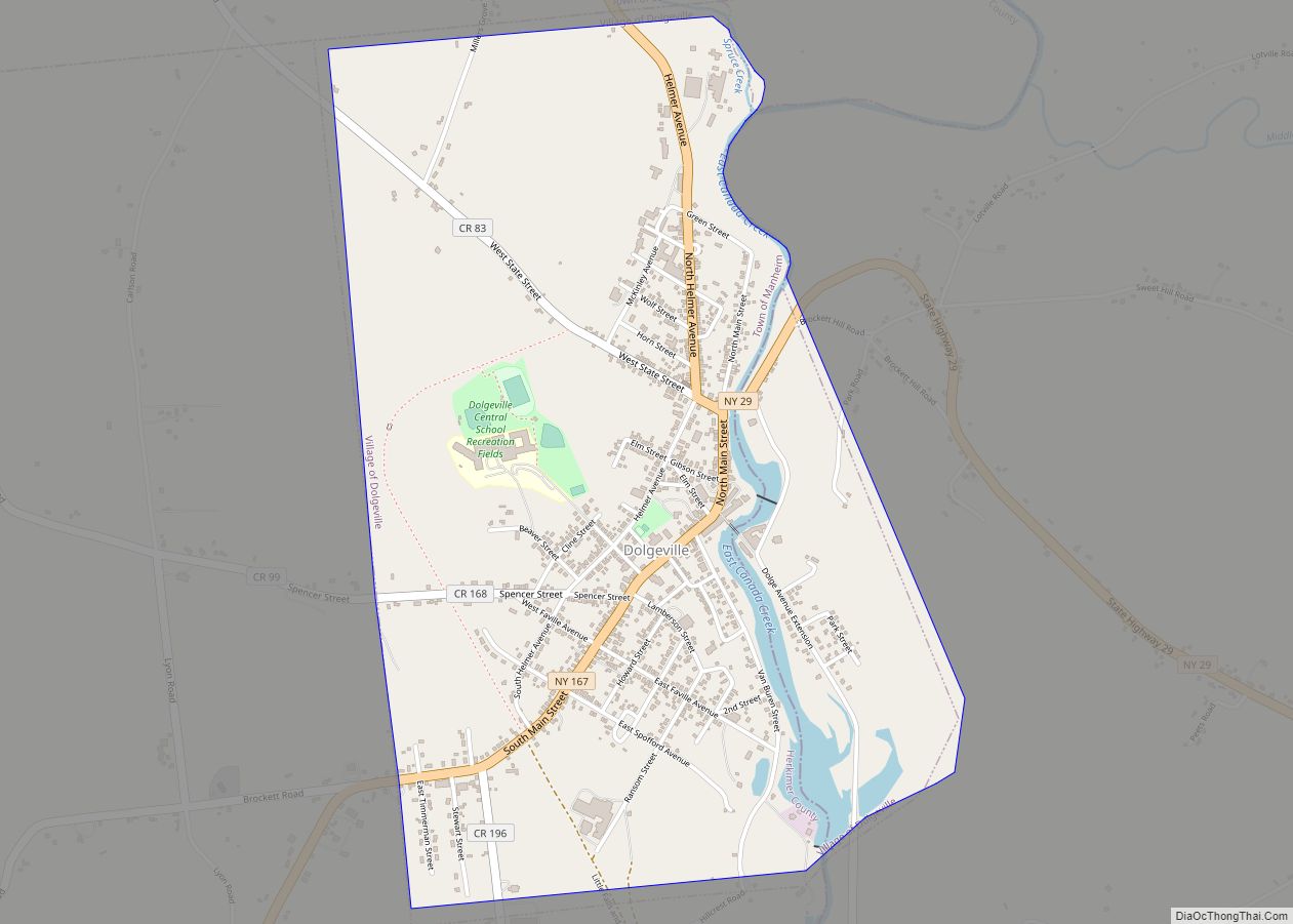
Dolgeville is a village in Herkimer and Fulton counties, New York, United States. The population was 2,206 at the 2010 census. The village is named after the industrialist Alfred Dolge. The village is mostly in the eastern part of the town of Manheim (Herkimer County), but is partly in the western edge of the town … Read more

Map of Durhamville CDP

Map of Durhamville CDP

Durhamville is a hamlet located in Oneida County, New York, United States. The population was 584 as of the 2010 census. The Hamlet of Durhamville is in the southern part of the county and is approximately 1.75 miles north of Oneida on Route 46. Durhamville CDP overview: Name: Durhamville CDP LSAD Code: 57 LSAD Description: … Read more

Map of Dunkirk city, New York

Map of Dunkirk city, New York

Dunkirk is a city in Chautauqua County, New York, United States. It was settled around 1805 and incorporated in 1880. The population was 12,743 as of the 2020 census. Dunkirk is bordered on the north by Lake Erie. It shares a border with the village of Fredonia to the south, and with the town of … Read more

Map of Dundee village, New York

Map of Dundee village, New York

Dundee is a village in Yates County, New York, United States. The population was 1,725 at the 2010 census. The name was taken from Dundee, the city in Scotland with a population of 148,260. The Village of Dundee is in the Town of Starkey. The village is in the Finger Lakes Region of New York, … Read more

Map of Duanesburg CDP

Map of Duanesburg CDP

Duanesburg is a census-designated place within the town of Duanesburg in Schenectady County, New York, United States. The name of the CDP is the name of a hamlet in that region of the town. The census provides separate or additional population and demographic data for the more densely populated central settlement described by the CDP. … Read more

Map of Duane Lake CDP

Map of Duane Lake CDP

Duane Lake is a census-designated place (CDP) in Schenectady County, New York, United States. The population was 323 at the 2010 census. The CDP is named after a small lake in the southern part of the town of Duanesburg. Duane Lake CDP overview: Name: Duane Lake CDP LSAD Code: 57 LSAD Description: CDP (suffix) State: … Read more

Map of Dryden village, New York

Map of Dryden village, New York

Dryden is a village in Tompkins County, New York, United States. The population was 1,890 at the 2010 census. The name was assigned by a clerk, interested in the classics, to honor poet John Dryden. The village is in the town of Dryden, east of Ithaca. It is near the border of Cortland County. Dryden … Read more

Map of East Hills village

Map of East Hills village

East Hills is a village in Nassau County, on the North Shore of Long Island, in New York, United States. It is considered part of the Greater Roslyn area, which is anchored by the Incorporated Village of Roslyn. The population was 6,955 at the 2010 census. The Incorporated Village of East Hills is located primarily … Read more

Map of East Hampton village, New York

Map of East Hampton village, New York

The Village of East Hampton is a village in Suffolk County, New York. It is located in the town of East Hampton on the South Fork of eastern Long Island. The population was 1,083 at the time of the 2010 census, 251 less than in the year 2000. It is a center of the summer … Read more

Map of East Hampton North CDP

Map of East Hampton North CDP

East Hampton North is a census-designated place (CDP) in Suffolk County, New York, United States. At the 2010 census, the population was 4,142. East Hampton North CDP overview: Name: East Hampton North CDP LSAD Code: 57 LSAD Description: CDP (suffix) State: New York County: Suffolk County Total Area: 5.57 sq mi (14.43 km²) Land Area: 5.57 sq mi (14.43 km²) Water … Read more