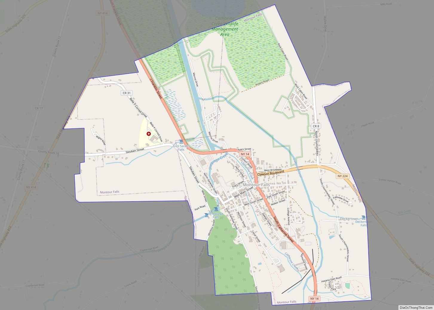
Map of Montebello village, New York
Montebello (Italian: “beautiful mountain”) is an incorporated village in Ramapo, Rockland County, New York, United States. It is located north of Suffern, east of Hillburn, south of Wesley Hills, and west of Airmont. The population was 4,526 at the 2010 census. Montebello village overview: Name: Montebello village LSAD Code: 47 LSAD Description: village (suffix) State: ... Read more
Map of Montebello village, New York
Map of Mount Sinai CDP
Mount Sinai is a hamlet and census-designated place (CDP) located within the Town of Brookhaven, in Suffolk County, New York, United States. The population was 12,118 at the 2010 census. The hamlet is located on the North Shore of Long Island. Mount Sinai was first settled in the 1660s and was known by the name ... Read more
Map of Mount Sinai CDP
Map of Mount Morris village, New York
Mount Morris is a village in the town of Mount Morris in Livingston County, New York, United States. The village population was 2,986 at the 2010 census, out of 4,465 in the entire town. The village and town are named after Robert Morris. The village is at the northeastern entrance to Letchworth State Park, which ... Read more
Map of Mount Morris village, New York
Map of Mount Kisco village
Mount Kisco is a village and town in Westchester County, New York, United States. The town of Mount Kisco is coterminous with the village. The population was 10,959 at the 2020 United States census over 10,877 at the 2010 census. It serves as a significant historic site along the Washington-Rochambeau Revolutionary Route. Mount Kisco village ... Read more
Map of Mount Kisco village
Map of Mount Ivy CDP
Mount Ivy is a hamlet and census-designated place in the Town of Haverstraw, in Rockland County, New York, United States. It is located north of New City, east of Pomona, south of Thiells, and west of Garnerville. The population was 6,878 at the 2010 census. Mount Ivy CDP overview: Name: Mount Ivy CDP LSAD Code: ... Read more
Map of Mount Ivy CDP
Map of Morrisville village, New York
Morrisville is a village in Madison County, New York, United States. The population was 2,199 at the 2010 census. The village is named after its founder, Thomas Morris. The Village of Morrisville in the northwest part of the Town of Eaton on US Route 20. Its zip code is 13408. Morrisville State College is located ... Read more
Map of Morrisville village, New York
Map of Morristown village, New York
Morristown is a hamlet (and census-designated place) and former village along the Saint Lawrence River in St. Lawrence County, New York, United States. The population was 395 at the 2010 census. The village is named after Gouverneur Morris. The hamlet is on the northern edge of the Town of Morristown and was north of Gouverneur. ... Read more
Map of Morristown village, New York
Map of Munsey Park village
Munsey Park is a village in Nassau County, on the North Shore of Long Island, in New York, United States. It is considered part of the Greater Manhasset area, which is anchored by Manhasset. The population was 2,809 at the 2020 census. The Incorporated Village of Munsey Park is located within the Town of North ... Read more
Map of Munsey Park village
Map of Munnsville village
Munnsville is a village located in the Town of Stockbridge in Madison County, New York, United States. The population was 474 at the 2010 census. The village is named for an early settler, Asa Munn, and located on New York State Route 46. Munnsville village overview: Name: Munnsville village LSAD Code: 47 LSAD Description: village ... Read more
Map of Munnsville village
Map of Mountain Lodge Park CDP
Mountain Lodge Park is in the town of Blooming Grove in Orange County, New York, United States. It is built on the western slope of Schunemunk Mountain, the highest in the county. The population was 1,910 as of the 2020 census. Mountain Lodge Park CDP overview: Name: Mountain Lodge Park CDP LSAD Code: 57 LSAD ... Read more
Map of Mountain Lodge Park CDP
Map of Mount Vernon city, New York
Mount Vernon is a city in Westchester County, New York, United States. It is an inner suburb of New York City, immediately to the north of the borough of the Bronx. As of the 2020 census, Mount Vernon had a population of 73,893, making it the eighth most populous city in the state (2020) and ... Read more
Map of Mount Vernon city, New York
Map of Natural Bridge CDP, New York
Natural Bridge is a hamlet and census-designated place (CDP) in Jefferson County, New York, United States. As of the 2010 census it had a population of 365. It is located in the northeastern corner of the town of Wilna and is east of Watertown. The name “Natural Bridge” was derived from a natural rock formation ... Read more
Map of Natural Bridge CDP, New York