Mount Vernon is a city in Westchester County, New York, United States. It is an inner suburb of New York City, immediately to the north of the borough of the Bronx. As of the 2020 census, Mount Vernon had a population of 73,893, making it the eighth most populous city in the state (2020) and largest African American majority city in the state (2020).
Mount Vernon has two major sections. South-side Mount Vernon is more urban while north-side Mount Vernon is more residential. Mount Vernon’s downtown business district is on the city’s south side, which features the City Hall, Mount Vernon’s main post office, Mount Vernon Public Library, office buildings, and other municipal establishments.
| Name: | Mount Vernon city |
|---|---|
| LSAD Code: | 25 |
| LSAD Description: | city (suffix) |
| State: | New York |
| County: | Westchester County |
| Elevation: | 108 ft (33 m) |
| Total Area: | 4.41 sq mi (11.42 km²) |
| Land Area: | 4.39 sq mi (11.38 km²) |
| Water Area: | 0.02 sq mi (0.04 km²) |
| Total Population: | 73,893 |
| Population Density: | 16,824.45/sq mi (6,495.76/km²) |
| Area code: | 914 |
| FIPS code: | 3649121 |
| GNISfeature ID: | 0957917 |
| Website: | cmvny.com |
Online Interactive Map
Click on ![]() to view map in "full screen" mode.
to view map in "full screen" mode.
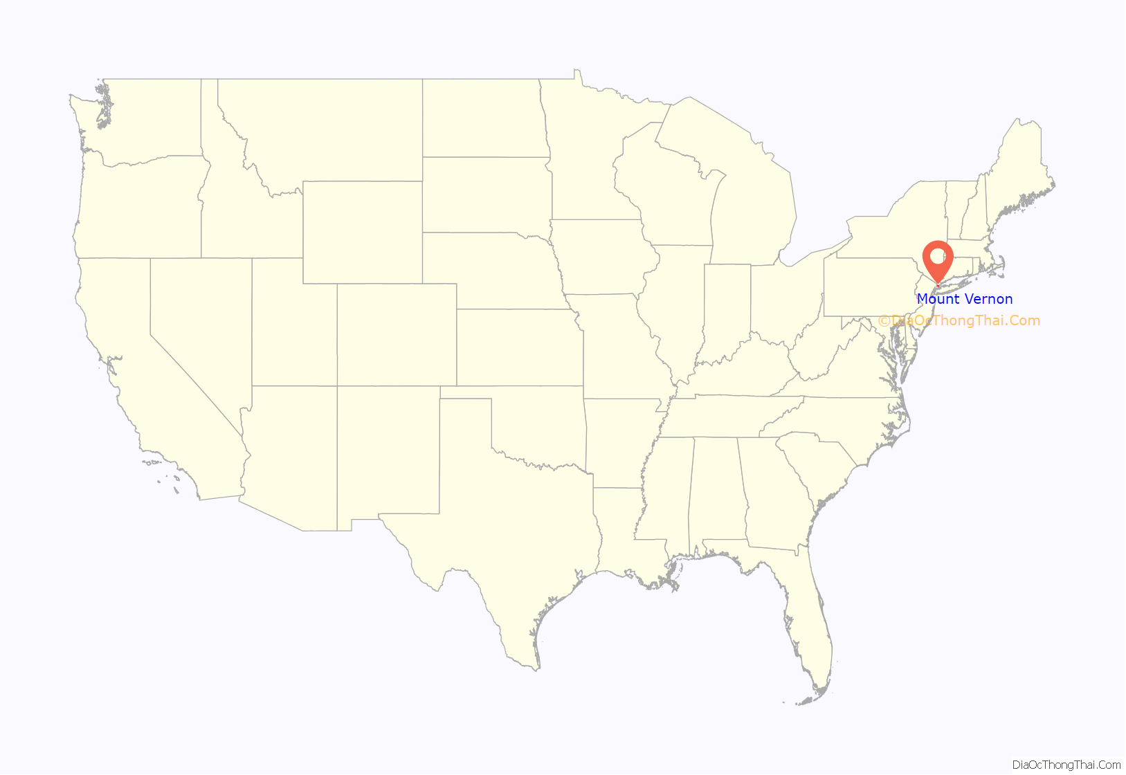
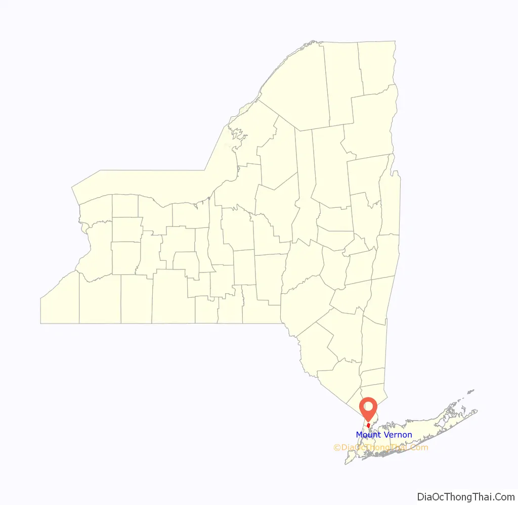
Mount Vernon location map. Where is Mount Vernon city?
History
The Mount Vernon area was first settled in 1664 by families from Connecticut as part of the Town of Eastchester. Mount Vernon became a village in 1853, and a city in 1892. Mount Vernon takes its name from George Washington’s Mount Vernon plantation in Virginia, much like neighboring Wakefield (in the Bronx) was named for the Virginia plantation where Washington was born (now part of George Washington Birthplace National Monument).
In 1894, the voters of Mount Vernon participated in a referendum on whether they wanted to consolidate into a new “City of Greater New York.” The cities of Brooklyn (coterminous with Kings County) and Long Island City, the western towns and villages of Queens County, and all of Richmond County (present day Staten Island) all voted to join with the existing city (present day Manhattan and The Bronx). However, the returns were so negative in Mount Vernon and the adjacent city of Yonkers that those two areas were not included in the consolidated city and remain independent to this day.
The Mount Vernon Public Library, a gift to the city from Andrew Carnegie, opened in 1904 and is now part of the Westchester Library System, providing educational, cultural and computer services to county residents of all ages. The Mount Vernon Trust Company, opened in 1903. It was the largest bank in Westchester County, with branches in the east and west sections of the city.
During the 1960s, Mount Vernon was a divided city on the brink of a “northern style” segregation. Many African Americans from the southern United States migrated north and settled in the city of Mount Vernon for better job opportunities and educational advancements. At the same time, many white Americans from the Bronx and Manhattan looked to Mount Vernon as a new “bedroom community” due to rising crime in New York City (a “white flight” factor contributed as well). As a result, Mount Vernon became divided in two by the New Haven Line railroad tracks of the Metro-North Railroad: North Side and South Side. The population south of the tracks became predominantly African American, while that north of the tracks was largely white.
At the height of this segregation in the 1970s, August Petrillo was mayor. When he died, Thomas E. Sharpe was elected mayor. Upon Sharpe’s death in 1984, Carmella Iaboni took office as “acting mayor” until Ronald Blackwood was elected; Blackwood was the first Afro-Caribbean mayor of the city (as well as of any city in New York State). In 1996, Ernest D. Davis was elected the mayor of Mount Vernon; he served until 2007. Clinton I. Young, Jr. became the city’s mayor on January 1, 2008. Four years later, on January 1, 2012, Ernest D. Davis became the 21st mayor of Mount Vernon. In 2013, Davis was investigated for failure to report rental income. In 2015, Richard Thomas ran against Davis (and several other opponents) and defeated him in an upset victory during the September primary. Thomas had to run again in the November general election, where he received 71% of the votes to become the Mayor of Mount Vernon.
In the subsequent 2019 election, Shawyn Patterson-Howard unseated the incumbent Mayor Thomas (as well as fellow candidates Clyde Isley and Councilman André Wallace, and others not on the final ballot including former Mayor Ernie Davis) in a hotly contested June primary to become the new Democratic nominee and went on to capture 81% of the vote to defeat André Wallace (who had since been named Acting Mayor and ran as a Republican) in the general election in November to become the first black woman elected mayor of Mount Vernon (and of any city in Westchester County).
Mount Vernon has in recent years undergone a transition from a city of homes and small businesses to a city of regional commerce. Between 2000 and 2006, the city of Mount Vernon’s economy grew 20.5%, making it one of the fastest-growing cities in the New York metropolitan area.
January 2019 Loss of Moody’s Rating
In January 2019, Moody withdrew its credit rating for Mount Vernon due to the City’s failure to provide audited financial statements. According to local press accounts of the situation and internal city memos obtained from the Mount Vernon city website, the failure to prepare and deliver audited financial statements stems from a disagreement as to which entity would pay for the audit of the Urban Renewal Agency (URA), one of the City’s agencies, and which auditing firm would perform the audit. Further clouding the City’s financial condition is the prospect that it might have a repayment obligation to HUD in connection with grants previously awarded to the City
2019 Mayoral dispute
On July 9, 2019, mayor Richard Thomas pled guilty to stealing campaign funds and lying to the State Board of Elections. As part of the terms of the guilty plea, Thomas was ordered to resign from office by September 30, 2019. The city council moved to remove Thomas from office under the city charter’s provision disqualifying felons from office, and appointed council president Andre Wallace as acting mayor. Thomas refused to resign from his post, citing the terms of the plea bargain. Wallace then appointed Shawn Harris as new police commissioner. After arriving for work, Thomas ordered the Mount Vernon Police to arrest Harris for trespassing. Harris was only released after an order from the Westchester County District Attorney. Both Thomas and Wallace occupied offices in the city hall, with Thomas in the mayor’s office, under the guard of the Mount Vernon Police. Finally, before a packed courtroom in White Plains, Judge Ecker made a decisive ruling that Thomas had actually vacated the office of mayor on July 8, that Wallace had automatically assumed the office at that time, and that Wallace would be the acting mayor of Mount Vernon until January 1, 2020.
Mount Vernon Charter Revision Commission
In March 2019, Mayor Richard Thomas called for the formation of the Mount Vernon Charter Revision Commission, suggesting the charter was antiquated, dating to the late 19th century. In August 2019, the Commission presented its final report which included four key proposed changes to the City’s Charter:
- A new requirement for annual financial audits.
- Quarterly financial reports showing the city’s fiscal condition.
- An updated comprehensive plan for economic growth.
- A periodic review of the city charter.
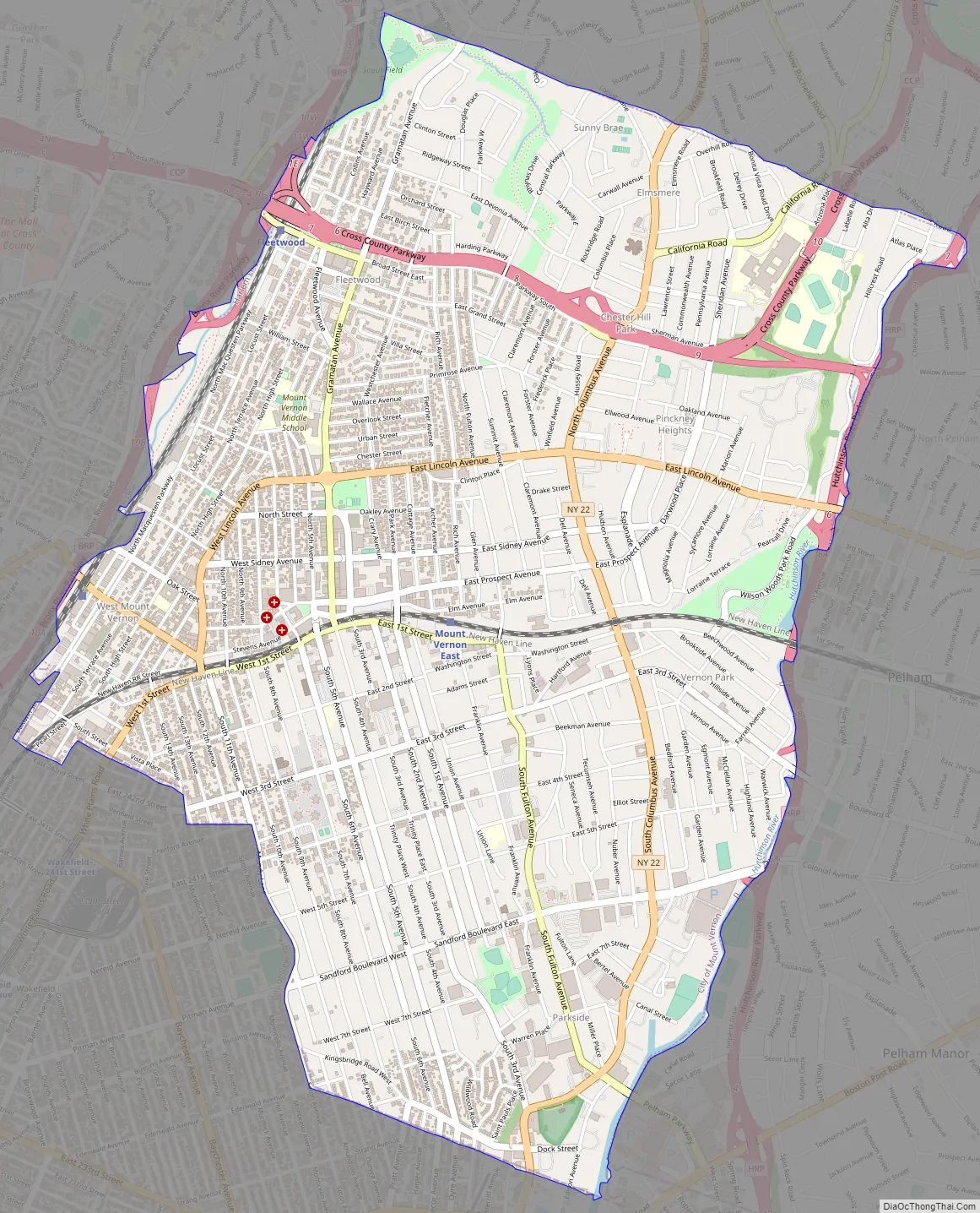
Mount Vernon Road Map
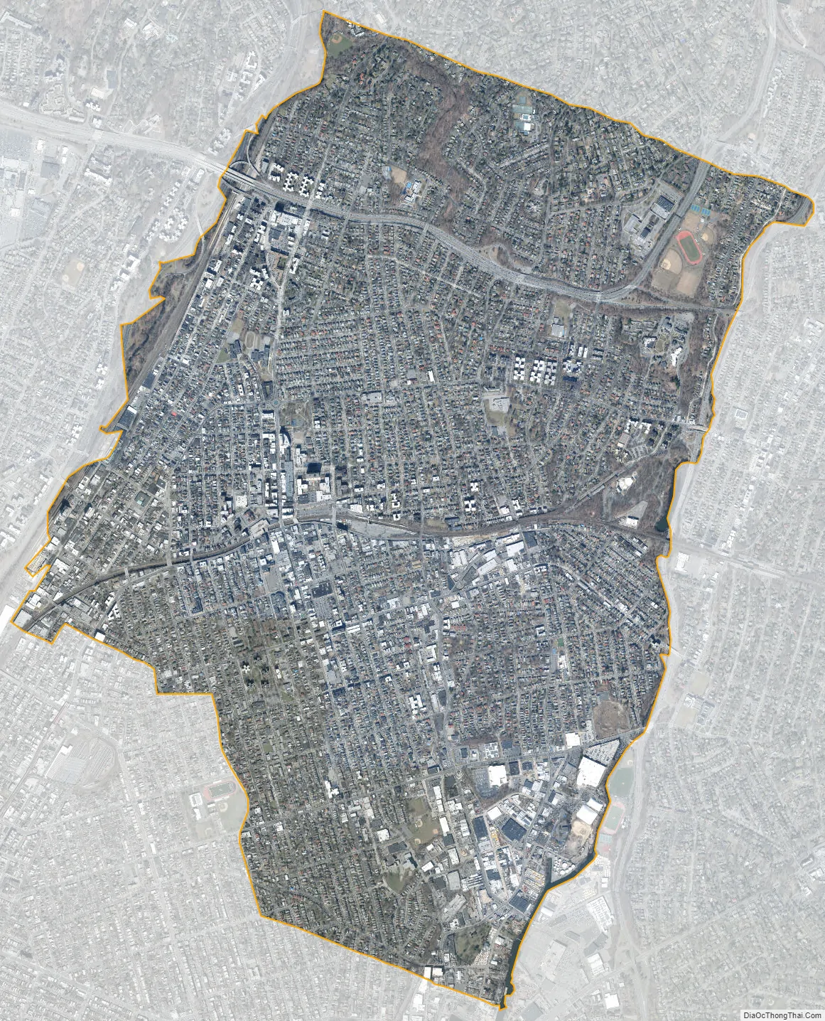
Mount Vernon city Satellite Map
Geography
Location
Mount Vernon is at 40°54′51″N 73°49′50″W / 40.914060°N 73.830507°W / 40.914060; -73.830507 (40.914060, -73.830507). It is the third-largest and the most densely populated city in Westchester County. According to the United States Census Bureau, the city has a total area of 4.4 square miles (11.4 km), of which 0.015 square miles (0.04 km), or 0.39%, is water.
Mount Vernon is bordered by the village of Bronxville and city of New Rochelle to the north, by the town of Pelham and village of Pelham Manor to the east, by the Hutchinson River and the Eastchester and Wakefield sections of the Bronx to the south, and by the city of Yonkers and the Bronx River to the west.
Elevation
Mount Vernon’s elevation at City Hall is about 235 feet (72 m), reflecting its location between the Bronx River to the west and the Hutchinson River to the east. On a clear day, the Throgs Neck Bridge can be seen from 10 miles (20 km) away from many parts of the city, while at night, the bridge’s lights can also be seen. The city’s seal, created in 1892, depicts what were then considered the highest points in Mount Vernon: Trinity Place near Fourth Street, Vista Place at Barnes Avenue, and North 10th Street between Washington and Jefferson places. Since then, it was discovered that the city’s highest elevation is on New York Route 22, North Columbus Avenue, at the Bronxville line.
Neighborhoods
Mount Vernon is typically divided into four major sections in four square miles: Downtown, Mount Vernon Heights, North Side, and South Side.
Downtown Mount Vernon features the Gramatan Avenue and Fourth Avenue shopping district (known as “The Avenue” by locals) and the Petrillo Plaza transit hub, and houses the city’s central government.
Downtown is in the same condition it was 40 years ago. It features the same mid-century architecture and format. Former mayor Clinton Young vowed to make Mount Vernon a new epicenter with a new central business district. His failed plans included establishing commercial office space and rezoning to allow high density development in the downtown, as well as affordable and market rate housing.
Mount Vernon Heights’ highly elevated terrain has earned the moniker “the rolling hills of homes”. It is home to the city’s commercial corridor, along Sandford Boulevard (6th Street).
Sandford Blvd (6th Street)—also known as “Sandford Square”—is a certified commercial corridor, which anchors businesses such as Bed Bath & Beyond, Best Buy, Colonial Plaza (a strip mall), CVS Pharmacy, Famous Footwear, Petco, Restaurant Depot, Staples, Stop and Shop, and Target. Sandford Square attracts residents from Mount Vernon, nearby communities in Westchester County and the Bronx, and shoppers from as far away as Connecticut via the Merritt Parkway and I-95, which merge onto the Hutchinson River Parkway.
Most of the commercial development in this corridor has occurred since the 1980s. The area is still undergoing revitalization to encourage economic development within this 400-acre (1.6 km) of land along and around the boulevard.
Mount Vernon’s North Side is one of the most ethnically diverse neighborhoods in Westchester County. The northern part of the city consists of five neighborhoods: Chester Heights, Estate Manor/Aubyn Estates, Fleetwood, Huntswood, and Oakwood Heights. In Fleetwood, many large co-op buildings line the center of town, which is bisected by Gramatan Avenue.
Mount Vernon’s South Side, which abuts The Bronx, resembles New York City and includes the neighborhoods Parkside, South Side and Vernon Park. Numerous industrial businesses are in Parkside, while the rest of South Side Mount Vernon features multi-family homes, apartment buildings, and commercial businesses.
South Side Mount Vernon features notable city landmarks such as Brush Park, Hutchinson Field, the Boys and Girls Club, and St. Paul’s Church National Historic Site.
See also
Map of New York State and its subdivision:- Albany
- Allegany
- Bronx
- Broome
- Cattaraugus
- Cayuga
- Chautauqua
- Chemung
- Chenango
- Clinton
- Columbia
- Cortland
- Delaware
- Dutchess
- Erie
- Essex
- Franklin
- Fulton
- Genesee
- Greene
- Hamilton
- Herkimer
- Jefferson
- Kings
- Lake Ontario
- Lewis
- Livingston
- Madison
- Monroe
- Montgomery
- Nassau
- New York
- Niagara
- Oneida
- Onondaga
- Ontario
- Orange
- Orleans
- Oswego
- Otsego
- Putnam
- Queens
- Rensselaer
- Richmond
- Rockland
- Saint Lawrence
- Saratoga
- Schenectady
- Schoharie
- Schuyler
- Seneca
- Steuben
- Suffolk
- Sullivan
- Tioga
- Tompkins
- Ulster
- Warren
- Washington
- Wayne
- Westchester
- Wyoming
- Yates
- Alabama
- Alaska
- Arizona
- Arkansas
- California
- Colorado
- Connecticut
- Delaware
- District of Columbia
- Florida
- Georgia
- Hawaii
- Idaho
- Illinois
- Indiana
- Iowa
- Kansas
- Kentucky
- Louisiana
- Maine
- Maryland
- Massachusetts
- Michigan
- Minnesota
- Mississippi
- Missouri
- Montana
- Nebraska
- Nevada
- New Hampshire
- New Jersey
- New Mexico
- New York
- North Carolina
- North Dakota
- Ohio
- Oklahoma
- Oregon
- Pennsylvania
- Rhode Island
- South Carolina
- South Dakota
- Tennessee
- Texas
- Utah
- Vermont
- Virginia
- Washington
- West Virginia
- Wisconsin
- Wyoming


