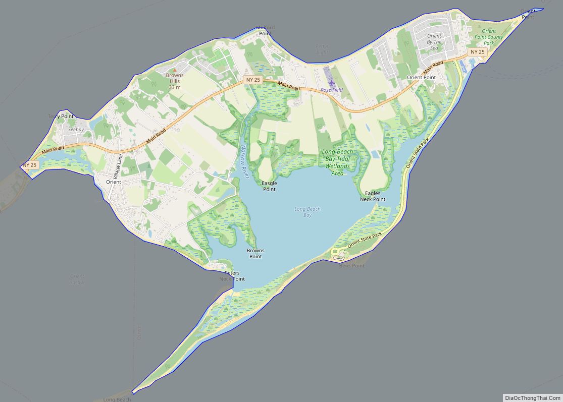
Map of Orchard Park village
Orchard Park is a village in Erie County, New York, United States. The population was 3,246 at the 2010 census. The name is derived from a description of the local landscape, which abounded with orchards. It is part of the Buffalo–Niagara Falls Metropolitan Statistical Area. The village of Orchard Park lies north of the center ... Read more
Map of Orchard Park village
Map of Orangeburg CDP, New York
Orangeburg is a hamlet and census-designated place, in the town of Orangetown, Rockland County, New York, United States. It is located north of Tappan, south of Blauvelt, east of Pearl River and west of Piermont. The population was 4,568 at the 2010 census. Orangeburg CDP overview: Name: Orangeburg CDP LSAD Code: 57 LSAD Description: CDP ... Read more
Map of Orangeburg CDP, New York
Map of Orange Lake CDP
Orange Lake is a hamlet (and census-designated place) in Orange County, New York, United States. The population was 9,770 at the 2020 census. It is part of the Newburgh–Middletown, NY Metropolitan Statistical Area as well as the larger New York–Newark–Bridgeport, NY-NJ–CT–PA Combined Statistical Area. The community of Orange Lake is in the western part of ... Read more
Map of Orange Lake CDP
Map of Oyster Bay CDP
Oyster Bay is a hamlet and census-designated place (CDP) within the town of Oyster Bay on the North Shore of Long Island in Nassau County in the state of New York, United States. The hamlet is also the site of a station on the Oyster Bay Branch of the Long Island Rail Road and the ... Read more
Map of Oyster Bay CDP
Map of Oyster Bay Cove village
Oyster Bay Cove is a village located within the Town of Oyster Bay in Nassau County, on Long island, in New York. The population was 2,197 at the 2010 census. Youngs Memorial Cemetery, resting place of President Theodore Roosevelt, is located in the village. Oyster Bay Cove village overview: Name: Oyster Bay Cove village LSAD ... Read more
Map of Oyster Bay Cove village
Map of Oxford village, New York
Oxford is a village in Chenango County, New York, United States. The population was 1,450 at the 2010 census. The village is named after Oxford, Massachusetts, the hometown of the landowner. The village of Oxford is in the northern part of the town of Oxford, southwest of the city of Norwich. Oxford village overview: Name: ... Read more
Map of Oxford village, New York
Map of Oxbow CDP, New York
Oxbow is a hamlet and census-designated place (CDP) in the town of Antwerp, Jefferson County, New York, United States. As of the 2010 census it had a population of 108. Oxbow CDP overview: Name: Oxbow CDP LSAD Code: 57 LSAD Description: CDP (suffix) State: New York County: Jefferson County Elevation: 351 ft (107 m) Total Area: 0.42 sq mi ... Read more
Map of Oxbow CDP, New York
Map of Owego village
Owego is a village in and the county seat of Tioga County, New York, United States. The population was 3,896 at the 2010 census. It is part of the Binghamton Metropolitan Statistical Area. The name is derived from the Iroquois word Ahwaga, meaning where the valley widens. The Village of Owego is by the west ... Read more
Map of Owego village
Map of Ovid village, New York
Ovid is a village in Seneca County, New York, United States. The population was 602 at the 2010 census. The town was named by a clerk interested in the classics (see Ovid). The Village of Ovid is within the Town of Ovid, but a small portion is in the Town of Romulus, and is southeast ... Read more
Map of Ovid village, New York
Map of Otisville village, New York
Otisville is a village in Orange County, New York, United States. The population was 969 at the 2020 census. It is part of the Poughkeepsie–Newburgh–Middletown, NY Metropolitan Statistical Area as well as the larger New York–Newark–Bridgeport, NY-NJ–CT–PA Combined Statistical Area. The village of Otisville is in the town of Mount Hope, located near the western ... Read more
Map of Otisville village, New York
Map of Otego village
Otego is a village in Otsego County, New York, United States. It is located within the Mohawk Valley Region of the state. The population was 1,010 at the 2010 census. The Village of Otego is in the southern part of the Town of Otego and is southwest of Oneonta. Otego village overview: Name: Otego village ... Read more
Map of Otego village
Map of Oswego city, New York
Oswego (/ɒsˈwiːɡoʊ/) is a city in Oswego County, New York, United States. The population was 16,921 at the 2020 census. Oswego is located on Lake Ontario in Upstate New York, about 35 miles (55km) northwest of Syracuse. It promotes itself as “The Port City of Central New York.” It is the county seat of Oswego ... Read more
Map of Oswego city, New York