Map of Rock Hill CDP, New York

Map of Rock Hill CDP, New York

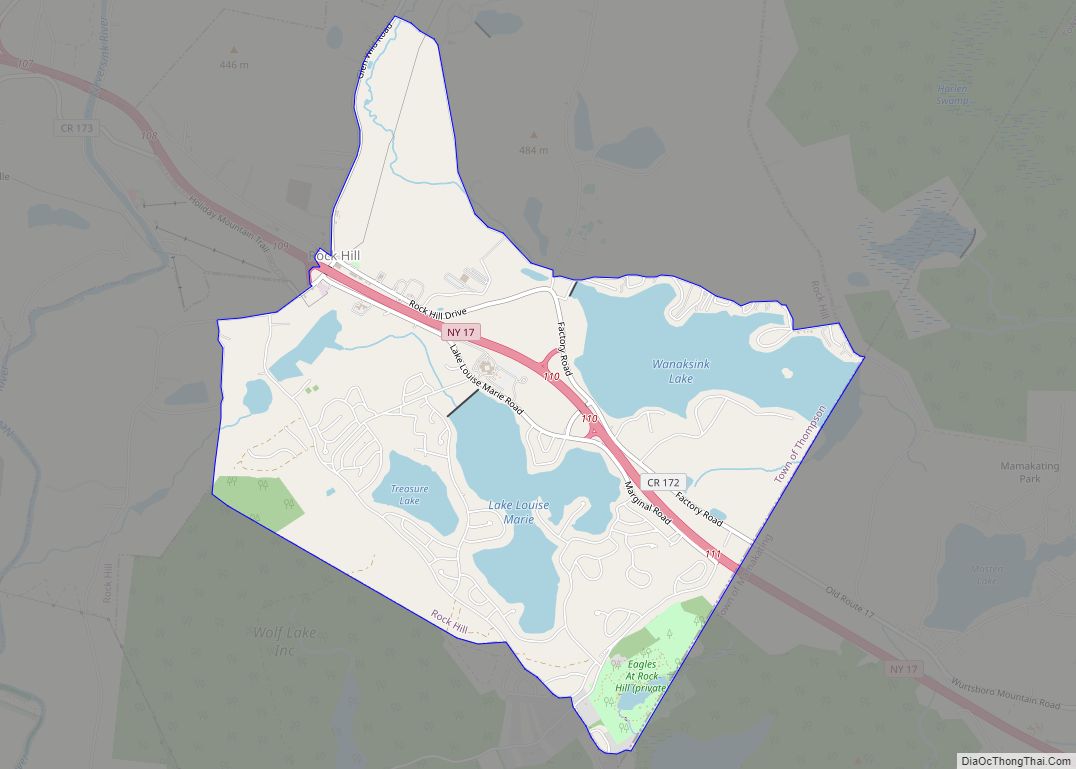
Rock Hill is a hamlet (and census-designated place) in Sullivan County, New York, United States. At the 2010 census the population was 1,742. Rock Hill is in the town of Thompson by New York State Route 17. Rock Hill CDP overview: Name: Rock Hill CDP LSAD Code: 57 LSAD Description: CDP (suffix) State: New York … Read more

Map of Riverside CDP, New York

Map of Riverside CDP, New York

Riverside is a hamlet and census-designated place (CDP) in Suffolk County, New York, United States. The population was 2,911 at the 2010 census. Riverside is in the Town of Southampton and derives its name from being on the south bank of the Peconic River. Riverside CDP overview: Name: Riverside CDP LSAD Code: 57 LSAD Description: … Read more

Map of Riverhead CDP

Map of Riverhead CDP

Riverhead is a census-designated place (CDP) roughly corresponding to the hamlet by the same name located in the Town of Riverhead in Suffolk County, on Long Island, in New York, United States. The CDP’s population was 13,299 at the 2010 census. Situated at the mouth of the Peconic River, which empties into Peconic Bay where … Read more

Map of Roslyn village

Map of Roslyn village, New York

Roslyn (/ˈrɒzlɪn/ ROZ-lin) is a village in the Town of North Hempstead in Nassau County, on the North Shore of Long Island, in New York, United States. It is the Greater Roslyn area’s anchor community. The population was 2,770 at the 2010 census. Roslyn village overview: Name: Roslyn village LSAD Code: 47 LSAD Description: village … Read more

Map of Roslyn Heights CDP

Map of Roslyn Heights CDP

Roslyn Heights is a hamlet and census-designated place (CDP) in the Town of North Hempstead in Nassau County, on Long Island, in New York, United States. It is considered part of the Greater Roslyn area, which is anchored by the Incorporated Village of Roslyn. The population was 6,577 at the 2010 census. Roslyn Heights CDP … Read more

Map of Roslyn Harbor village

Map of Roslyn Harbor village

Roslyn Harbor is a village in Nassau County, on the North Shore of Long Island, in New York, United States. It is considered part of the Greater Roslyn area, which is anchored by the Incorporated Village of Roslyn. The population was 1,051 at the 2010 census. The Incorporated Village of Roslyn Harbor lies in both … Read more

Map of Roslyn Estates village

Map of Roslyn Estates village

Roslyn Estates is a village in the Town of North Hempstead in Nassau County, on the North Shore of Long Island, in New York, United States. It is considered part of the Greater Roslyn area, which is anchored by the Incorporated Village of Roslyn. The population was 1,318 at the 2020 census. Roslyn Estates village … Read more

Map of Rosendale Hamlet CDP

Map of Rosendale Hamlet CDP

Rosendale Hamlet CDP overview: Name: Rosendale Hamlet CDP LSAD Code: 57 LSAD Description: CDP (suffix) State: New York County: Ulster County FIPS code: 3663742 Online Interactive Map Rosendale Hamlet online map. Source: Basemap layers from Google Map, Open Street Map (OSM), Arcgisonline, Wmflabs. Boundary Data from Database of Global Administrative Areas. Rosendale Hamlet location map. … Read more

Map of Roscoe CDP, New York

Map of Roscoe CDP, New York

Roscoe is a hamlet (and census-designated place) in Sullivan County, New York, United States. The population was 541 at the 2010 census. Roscoe is in the southwest part of the Town of Rockland, adjacent to New York State Route 17. It is named for New York Senator Roscoe Conkling. Roscoe calls itself “Trout Town, USA.” … Read more

Map of Rushford CDP, New York

Map of Rushford CDP, New York

Rushford is a census-designated place comprising the central settlement in the town of Rushford, Allegany County, New York, United States. As of the 2010 census, it had a population of 363, out of a total population of 1,150 in the town. Rushford CDP overview: Name: Rushford CDP LSAD Code: 57 LSAD Description: CDP (suffix) State: … Read more

Map of Rouses Point village

Map of Rouses Point village

Rouses Point is a village in Clinton County, New York, United States, along the 45th parallel. The population was 2,209 at the 2010 census. The village is named after Jacques Rouse, a French Canadian soldier who fought alongside the Americans during their war for independence. The village is on the western shore of Lake Champlain … Read more

Map of Round Lake village, New York

Map of Round Lake village, New York

Round Lake is a village in Saratoga County, New York, United States. The population was 1,245 at the 2020 census. The name is derived from a circular lake adjacent to the village. In 1975, the Round Lake Historic District, which encompasses the village, was added to the National Register of Historic Places. The Village of … Read more