Map of Waterville village, New York
Waterville (called Ska-na-wis, “long swamp” by the Haudenosaunee) is a village in Oneida County, New York, United States. According to the 2010 census, its population was 1,583. Waterville village overview: Name: Waterville village LSAD Code: 47 LSAD Description: village (suffix) State: New York County: Oneida County Elevation: 1,201 ft (366 m) Total Area: 1.42 sq mi (3.67 km²) Land Area: ... Read more
Map of Waterville village, New York
Map of Watertown city, New York
Watertown is a city in, and the county seat of, Jefferson County, New York, United States. It is approximately 25 miles (40 km) south of the Thousand Islands, along the Black River about 5 miles (8 km) east of where it flows into Lake Ontario. The city is bordered by the town of Watertown to the south, ... Read more
Map of Watertown city, New York
Map of Waterloo village, New York
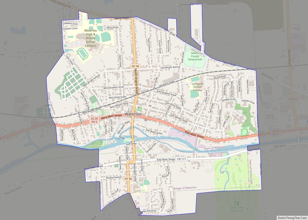
Waterloo is a village and primary county seat of Seneca County, New York, United States. The population was 5,171 at the 2010 census and is now the most populated village in Seneca County. The village is named after Waterloo, Belgium, where Napoleon was defeated. It is the primary county seat of Seneca County, with the ... Read more
Map of Waterloo village, New York
Map of Waterford village, New York
Waterford is a village in Saratoga County, New York, United States. The population was 1,990 at the 2010 census. The name derives from the ford between the mainland and Peebles Island. The Village of Waterford is located in the southeastern part of the Town of Waterford, north-northwest of Troy, New York. The village is located ... Read more
Map of Waterford village, New York
Map of Water Mill CDP
Water Mill is a hamlet and a census-designated place (CDP) within the Town of Southampton on Long Island in Suffolk County, New York, United States. The population of the CDP was 1,559 at the 2010 census. Its ZIP Code is 11976. As of 2010, Water Mill was listed as the fourteenth most expensive ZIP Code ... Read more
Map of Water Mill CDP
Map of Watchtower CDP
Watchtower is a hamlet (and census-designated place) located in the Town of Shawangunk, Ulster County, New York, United States. The population was 1,709 at the 2020 census. It is owned and operated by the Watchtower Society (a legal entity of Jehovah’s Witnesses) and has been in operation since 1963. Watchtower CDP overview: Name: Watchtower CDP ... Read more
Map of Watchtower CDP
Map of Washingtonville village, New York
Washingtonville is a village in the town of Blooming Grove, Orange County, New York, United States. The population was 5,657 at the 2020 census. It is part of the Poughkeepsie–Newburgh–Middletown, NY Metropolitan Statistical Area as well as the larger New York–Newark–Bridgeport, NY-NJ–CT–PA Combined Statistical Area. The village is named in honor of George Washington. Washingtonville ... Read more
Map of Washingtonville village, New York
Map of Washington Mills CDP
Washington Mills is a hamlet and census-designated place in the Town of New Hartford, a suburb of Utica, New York, United States. Washington Mills is located off New York State Route 8. Washington Mills CDP overview: Name: Washington Mills CDP LSAD Code: 57 LSAD Description: CDP (suffix) State: New York County: Oneida County FIPS code: ... Read more
Map of Washington Mills CDP
Map of Washington Heights CDP
Washington Heights is a census-designated place (CDP) in Orange County, New York, United States. The population was 2,205 at the 2020 census. Washington Heights is a contiguous suburb of City of Middletown. The community is in the Town of Wallkill. Washington Heights CDP overview: Name: Washington Heights CDP LSAD Code: 57 LSAD Description: CDP (suffix) ... Read more
Map of Washington Heights CDP
Map of Weedsport village
Weedsport is a village in Cayuga County, New York, United States. The population was 1,815 at the 2010 census. The name is from Elihu and Edward Weed, merchants who helped found the village. Weedsport is in the town of Brutus, west of Syracuse. It was a port on the Erie Canal. Whitford’s Airport is north ... Read more
Map of Weedsport village
Map of Websters Crossing CDP
Websters Crossing is a hamlet and census-designated place (CDP) in the town of Springwater, Livingston County, New York, United States. Its population was 69 as of the 2010 census. New York State Route 15 passes through the community. Websters Crossing CDP overview: Name: Websters Crossing CDP LSAD Code: 57 LSAD Description: CDP (suffix) State: New ... Read more
Map of Websters Crossing CDP
Map of Webster village, New York
Webster is a village in Monroe County, New York. The population was 5,399 at the time of the 2010 census. The village and town are named after orator and statesman Daniel Webster. The Village of Webster lies near the center of the Town of Webster. It was incorporated in 1905. The village is crossed by ... Read more
Map of Webster village, New York