Map of Eden city, North Carolina
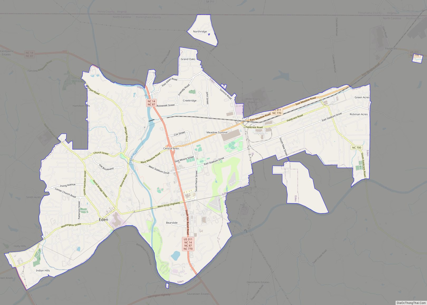
Eden is a city in Rockingham County in the U.S. state of North Carolina and is part of the Greensboro-High Point Metropolitan Statistical Area of the Piedmont Triad metro region. As of the 2020 census, the population was 15,405. From the late nineteenth century through much of the 20th, the city was a center of ... Read more
Map of Eden city, North Carolina
Map of Eastover town, North Carolina
Eastover is a town in Cumberland County, North Carolina, United States. The population was 3,628 at the 2010 census. It was incorporated on July 25, 2007. Eastover town overview: Name: Eastover town LSAD Code: 43 LSAD Description: town (suffix) State: North Carolina County: Cumberland County Incorporated: 2007 Elevation: 128 ft (39 m) Total Area: 11.34 sq mi (29.36 km²) Land ... Read more
Map of Eastover town, North Carolina
Map of East Spencer town
East Spencer is a town in Rowan County, North Carolina, United States. The population was 1,534 at the 2010 census. Originally called “Southern City” because of significance of the railway to the area, it was incorporated in 1901 as East Spencer. It was named for the Spencer shops that opened in the area in 1896. ... Read more
Map of East Spencer town
Map of East Rockingham CDP
East Rockingham is a census-designated place (CDP) in Richmond County, North Carolina, United States. The population was 3,885 at the 2000 census. East Rockingham CDP overview: Name: East Rockingham CDP LSAD Code: 57 LSAD Description: CDP (suffix) State: North Carolina County: Richmond County Elevation: 256 ft (78 m) Total Area: 3.44 sq mi (8.91 km²) Land Area: 3.42 sq mi (8.85 km²) Water ... Read more
Map of East Rockingham CDP
Map of East Laurinburg town
East Laurinburg town overview: Name: East Laurinburg town LSAD Code: 43 LSAD Description: town (suffix) State: North Carolina County: Scotland County FIPS code: 3719620 Online Interactive Map East Laurinburg online map. Source: Basemap layers from Google Map, Open Street Map (OSM), Arcgisonline, Wmflabs. Boundary Data from Database of Global Administrative Areas. East Laurinburg location map. ... Read more
Map of East Laurinburg town
Map of East Flat Rock CDP
East Flat Rock is an unincorporated area and census-designated place (CDP) in Henderson County, North Carolina, United States. The population was 4,995 at the 2010 census, up from 4,151 at the 2000 census. It is part of the Asheville Metropolitan Statistical Area. East Flat Rock CDP overview: Name: East Flat Rock CDP LSAD Code: 57 ... Read more
Map of East Flat Rock CDP
Map of Ellenboro town, North Carolina
Ellenboro is a town in Rutherford County, North Carolina, United States. The population was 873 at the 2010 census. Ellenboro town overview: Name: Ellenboro town LSAD Code: 43 LSAD Description: town (suffix) State: North Carolina County: Rutherford County Elevation: 1,063 ft (324 m) Total Area: 1.26 sq mi (3.28 km²) Land Area: 1.26 sq mi (3.28 km²) Water Area: 0.00 sq mi (0.00 km²) Total Population: ... Read more
Map of Ellenboro town, North Carolina
Map of Elkin town
Elkin is a town in Surry and Wilkes counties in the U.S. state of North Carolina, along the Yadkin River. Elkin shares its name with the surrounding township of Elkin Township. The population was 4,083 at the 2020 census. Elkin town overview: Name: Elkin town LSAD Code: 43 LSAD Description: town (suffix) State: North Carolina ... Read more
Map of Elkin town
Map of Elk Park town
Elk Park is a town in Avery County, North Carolina, United States. The town was so named because of the number of elk killed there. The population was 452 at the 2010 census. Elk Park town overview: Name: Elk Park town LSAD Code: 43 LSAD Description: town (suffix) State: North Carolina County: Avery County Incorporated: ... Read more
Map of Elk Park town
Map of Elizabethtown town, North Carolina
Elizabethtown is a town in Bladen County, North Carolina, United States. The population was 3,583 at the 2010 census. It is the county seat of Bladen County. Elizabethtown town overview: Name: Elizabethtown town LSAD Code: 43 LSAD Description: town (suffix) State: North Carolina County: Bladen County Elevation: 108 ft (33 m) Total Area: 5.11 sq mi (13.24 km²) Land Area: ... Read more
Map of Elizabethtown town, North Carolina
Map of Emerald Isle town
Emerald Isle is a town in Carteret County, North Carolina, United States. It is part of the Crystal Coast and is located entirely on Bogue Banks. The population was 3,847 at the 2020 census, but as many as 50,000 tourists each week inhabit the area during the summer season, filling up vacant rental properties that ... Read more
Map of Emerald Isle town
Map of Elroy CDP, North Carolina
Elroy is a town in Wayne County, North Carolina, United States. In 2007, the estimated population was 3,905. It is included in the Goldsboro, North Carolina Metropolitan Statistical Area. Elroy CDP overview: Name: Elroy CDP LSAD Code: 57 LSAD Description: CDP (suffix) State: North Carolina County: Wayne County Elevation: 112 ft (34 m) Total Area: 6.54 sq mi (16.93 km²) ... Read more
Map of Elroy CDP, North Carolina